Kızılırmak River
| Kızılırmak | |
| Halys | |
| River | |
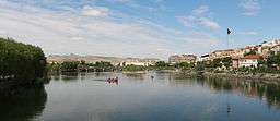 Kızılırmak in Avanos | |
| Country | Turkey |
|---|---|
| Tributaries | |
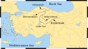
| - left | Devrez River, Gök River |
| - right | Delice River |
| Cities | Sivas, Kırşehir, Kırıkkale |
| Source | |
| - location | İmranlı, Sivas Province |
| - elevation | 2,000 m (6,562 ft) |
| - coordinates | 39°48′N 38°18′E / 39.800°N 38.300°E |
| Mouth | Black Sea |
| - location | Bafra, Samsun Province |
| - elevation | 0 m (0 ft) |
| - coordinates | 41°44′04″N 35°57′23″E / 41.73444°N 35.95639°ECoordinates: 41°44′04″N 35°57′23″E / 41.73444°N 35.95639°E |
| Length | 1,355 km (842 mi) |
 Map of the Kızılırmak watershed | |
| Official name | Kizilirmak Delta |
| Designated | April 15, 1998 [1] |
The Kızılırmak (Turkish for "Red River"), also known as the Halys River (Ancient Greek: Ἅλυς), is the longest river entirely within Turkey. It is a source of hydroelectric power and is not used for navigation.
Geography
The Kızılırmak flows for a total of 1,355 kilometres (842 mi),[2] rising in Eastern Anatolia around 39°48′N 38°18′E / 39.8°N 38.3°E, flowing first to the west and southwest until 38°42′N 34°48′E / 38.7°N 34.8°E, then forming a wide arch, the "Halys bend", flowing first to the west, then to the northwest, passing to the northeast of Lake Tuz, then to the north and northeast, where it is joined by its major tributary, the Delice River (also known by its Greek name Cappadox) at 40°28′N 34°08′E / 40.47°N 34.14°E, and after zigzagging to the northwest to the confluence with the Devrez River at 41°06′N 34°25′E / 41.10°N 34.42°E, and back to the northeast, joining the Gökırmak before finally flowing through its delta into the Black Sea at 41°43′N 35°57′E / 41.72°N 35.95°E. Dams on the river include the Boyabat, Altınkaya and Derbent.
History
The Hittites called it the Maraššantiya. It formed the western boundary of Hatti, the core land of the Hittite empire.
Until the Roman conquest of Anatolia the Kızılırmak, also called the Halys River, served as a natural political boundary in central Asia Minor, first between the kingdom of Lydia and the Persian Empire, and later between the Pontic Kingdom and the Kingdom of Cappadocia. In the 1st century AD Vespasian combined several provinces, including Cappadocia, to create one large province; its eastern boundary was marked by the Euphrates River. This province once again splintered during Trajan's reign—the newly created province of Cappadocia, bounded by the Euphrates to the East, included Pontus and Lesser Armenia. The Halys River remained an interior river and never regained its significance as a political border. In the 130s a governor of Cappadocia wrote: "long ago the Halys River was the boundary between the kingdom of Croesus and the Persian Empire; now it flows under Roman dominion."[3]
As the site of the Battle of Halys or Battle of the Eclipse on May 28, 585 BC,[4] it was the border between Lydia to the west and Media to the east until Croesus of Lydia crossed it to attack Cyrus the Great in 547 BC. He was defeated and Persia expanded to the Aegean Sea.
Agriculture
The river water is used to grow rice and in some areas water buffalo are kept.
In popular culture
The historical fiction manga Red River is named after and largely set in the Kızılırmak basin, during the age of the Hittites.
References
- ↑ "Ramsar List". Ramsar.org. Archived from the original on 9 April 2013. Retrieved 13 April 2013.
- ↑ Turkish Statistical Institute (2011). "Land and Climate". Turkey in Statistics 2011: The Summary of Turkey’s Statistical Yearbook, 2011. p. 2.
- ↑ Dam, Raymond Van (2002-08-30). Kingdom of Snow: Roman Rule and Greek Culture in Cappadocia. University of Pennsylvania Press. ISBN 978-0-8122-3681-1.
- ↑ Historically it was known as the Battle of Halys; it has since been renamed by some as the Battle of the Eclipse, as the first premodern battle which can be dated with certainty due to the eclipse which brought about its sudden end.
External links
- Livius.org: Halys - Photos
- sdu.dk/halys
-
| Wikimedia Commons has media related to Kızılırmak River. |