Numbered highways in the United States
Highways in the United States are split into at least four different types of systems, Interstate Highways, U.S. Highways, state highways, and county highways. Highways are generally organized by a route number or letter. These designations are generally displayed along the route by means of a highway shield. Each system has its own unique shield design that will allow quick identification to which system the route belongs. Below is a list of the different highway shields used throughout the United States.
Interstate Highways


.svg.png)


The Interstate Highway System is a federally funded and administered (but state-maintained) system of freeways that forms the transportation backbone of the U.S., with millions of Americans relying on it for commutes, long-distance travel, and freight transport daily. Interstate highways are all constructed to precise standards, designed to maximize high-speed travel safety and efficiency. Interstate Highways also contain auxiliary routes, which are normally assigned a three-digit route number. All Interstate Highways are part of the National Highway System, a network of highways deemed essential to the defense, economy, and mobility of the country.
U.S. Highways
The United States Numbered Highway System is an older system consisting mostly of surface-level trunk roads, coordinated by the American Association of State Highway and Transportation Officials and maintained by state and local governments. U.S. Highways have been relegated to regional and intrastate traffic, as they have been largely supplanted by the Interstate system for long-distance travel except in areas (especially in the west) where the Interstate system is absent or underdeveloped. This has led to the decommissioning and truncation of U.S. Highways that were formerly vital long-haul routes, such as U.S. Route 21 and U.S. Route 66.
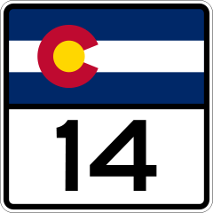
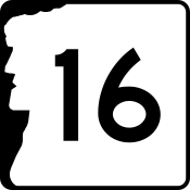
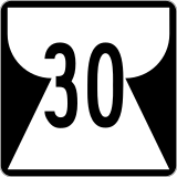
State highways


.svg.png)


.svg.png)


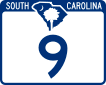

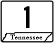


Each state also has a state highway system. State highways are of varying standards, capacity, and quality. Some state highways become so heavily traveled they are built to Interstate Highway standards. Others are more lightly traveled and have low capacity.
Many state highway markers are designed to suggest the geographic shape of the state or some other state symbol such as its flag. Most of the others are generically rectangular or some other neutral shape. The default design for state highway markers is the circular highway shield, which is how state highways are designated on most maps. Currently, five states—Delaware, Iowa, Kentucky, Mississippi, and New Jersey—use the circular shield for road signage on their state highways.[1]
Territorial highways
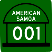


There are also numbered highways in Washington, D.C. and several U.S. territories. Likewise, they may also vary in standards and quality.
Secondary highways


Some states may include a secondary highway system to supplement the main one, usually for a specific purpose. For example, Texas established a system of farm-to-market roads to specifically improve access to rural areas. Nebraska has Connecting Link, Spur, and Recreation Highways to provide access to small towns and state parks. The Missouri supplemental route system was designed to provide access to most farm houses, schools, churches, cemeteries, and stores within the state.
County highways
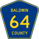


The final administrative level in some states is the county highway. As the name suggests, this type of road is maintained by a county. County roads vary widely from well-traveled multilane highways to dirt roads into remote parts of the county. In Louisiana, parish roads exist in place of county highways, as counties in that state are called parishes. Alaska also has no counties, and all roads are maintained at the national, state or municipal level. In some states, such as Massachusetts, county roads are now administered by regional entities.[2]
Other systems


Other highway systems include:
- Forest Highway: Highways connecting U.S. National Forests to the existing state highway systems, and thus provide improved access to recreational and logging areas.
- Indian route: Highways found in several Indian reservations.
- U.S. Bicycle Route: Part of the national cycling route network in the U.S., consisting of interstate long-distance cycling routes that use multiple types of bicycling infrastructure, including off-road paths, bicycle lanes, and low-traffic roads.
- Local highways: City and local governments may have their own highways, such as Charlotte Route 4 in Charlotte, North Carolina and the Inner Loop in Rochester, New York.
- Some townships also maintain Township Routes.
History
In 1918, Wisconsin became the first state to number its highways in the field.[3] In 1926 the American Association of State Highway Officials (AASHO) established and numbered interstate routes (United States Numbered Highways), selecting the best roads in each state that could be connected to provide a rational network of federal highways.[4]
See also
References
- ↑ Federal Highway Administration (2009). "Section 2D.11 Design of Route Signs". Manual on Uniform Traffic Control Devices (2009 2nd revised ed.). Washington, DC: Federal Highway Administration.
Guidance: State Route signs...should be rectangular and should be approximately the same size as the U.S. Route sign....The shape of the white area should be circular in the absence of any determination to the contrary by the individual State concerned.
- ↑ "County Roads". Hampshire Council of Governments. Retrieved August 16, 2017.
- ↑ "The Yellowstone Trail". South Milwaukee, Wisconsin. Archived from the original on June 8, 2005. Retrieved June 8, 2007.
- ↑ Weingroff, Richard F. (November 18, 2015). "From Names to Numbers: The Origins of the U.S. Numbered Highway System". Federal Highway Administration. Retrieved November 18, 2015.
External links
| Wikimedia Commons has media related to State highways in the United States. |
- Full list of state route markers
- Old Trails - US and Canadian Roads in the 20th Century (includes drawings and photos of old signs)