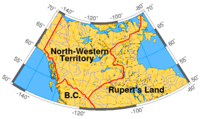
The North-Western Territory at its greatest extent, 1859.
The North-Western Territory was a region of British North America until 1870. Named for where it lay in relation to Rupert's Land, the territory at its greatest extent covered what is now Yukon, mainland Northwest Territories, northwestern mainland Nunavut, northwestern Saskatchewan, northern Alberta and northern British Columbia. Some of this area was originally part of Rupert's Land due to inaccurate maps. The acquisition of Rupert's Land was the largest land purchase in Canada's history.
History
It is obscure when exactly the United Kingdom first asserted sovereignty over the territory; however, after France accepted British sovereignty over the Hudson Bay coast by the Treaty of Utrecht (1713), The UK was the only European power with practical access to that part of the continent. The Hudson's Bay Company, despite the royal charter assigning only Rupert's Land to the company, had long used the region as part of its trading area before the governance of the North-Western Territory was explicitly assigned to the company in 1859. As well, large areas of Rupert's Land were not accurately mapped then to know the precise boundaries. The British made virtually no effort to assert sovereignty over the aboriginal peoples of the area. In accordance with the Royal Proclamation of 1763, large-scale settlement by non-aboriginal people was prohibited until the lands were surrendered by treaty.[1]
In 1862 during the Stikine Gold Rush, part of the North-Western Territory became the Stickeen (Stikine) Territory when the Stikine became inundated by American miners and, to prevent any resulting American claims to or agitation for the region, Governor James Douglas of the Vancouver Island and British Columbia colonies declared the area a British territory. The coastal area at the mouth of the Stikine was part of Russian America at the time, but the British had rights of free navigation to the Stikine by treaties in 1825 and 1839 as well as a lease of coastal lands to the south of it. The boundary of the North-Western Territory in this region, and likewise the Stickeen Territories created from it, south of and northwards from the Stikine, had been set as "ten marine leagues" from the sea, but this remained undefined until the Alaska Boundary Settlement of 1903. The North-Western Territory's boundary with Russian America north of the 60th Parallel had been set at the 141st line of longitude by the Treaty of St. Petersburg in 1825.
The year following the creation of the Stickeen Territories, part of the Stikine returned to the North-Western Territory when boundaries were adjusted and the Colony of British Columbia was extended to the 60th parallel north, a measure which also brought into British Columbia its portion of the Peace River Block, which had not been part of the Stikine Territory. In 1868, shortly after Canadian Confederation, the Hudson's Bay Company agreed to surrender its vast territories to the new dominion. However, it was not until July 15, 1870, that the transfer to Canada was made. On that date the North-Western Territory became part of the newly created Northwest Territories. In 1880, the British Arctic Territories were claimed by Canada and later formed the Northwest Territories and Nunavut. In 1898 the Yukon Territory was formed when the areas west of the Mackenzie Mountains were removed from the Northwest Territories during the Klondike Gold Rush, again as with the Stickeen Territory to prevent efforts at American takeover and also to enable easier governance.[2]
External links
|
|---|
|
|
North America |
|---|
| 17th century and before | 18th century | 19th and 20th century | | | | |
| |
|
|
Africa |
|---|
| 17th and 18th centuries | 19th century | 20th century | | | | |
| |
|
Asia |
|---|
| 17th and 18th century | 19th century | 20th century | | | | |
| |
|
Oceania |
|---|
| 18th and 19th centuries | 20th century | | | |
| |
|
Antarctica and South Atlantic |
|---|
|
- 14. Since 2009 part of Saint Helena, Ascension and Tristan da Cunha; Ascension Island (1922–) and Tristan da Cunha (1938–) were previously dependencies of Saint Helena.
- 15. Both claimed in 1908; territories formed in 1962 (British Antarctic Territory) and 1985 (South Georgia and the South Sandwich Islands).
|
|
|