Province of West Jersey
|
|---|
|
1674–1702 |
| Status |
Colony of England |
|---|
| Capital |
Burlington |
|---|
| Common languages |
English |
|---|
| Government |
Constitutional monarchy |
|---|
| History |
|
|---|
|
|
• Established |
1674 |
|---|
• Disestablished |
1702 |
|---|
|
|
| Currency |
Pound sterling |
|---|
|
|
| Today part of |
 United States United States
|
|---|
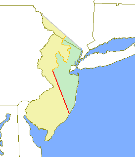
The original provinces of West and East Jersey are shown in yellow and green respectively. The
Keith Line is shown in red, and the
Coxe-Barclay Line is shown in orange
West Jersey and East Jersey were two distinct parts of the Province of New Jersey. The political division existed for 28 years, between 1674 and 1702. Determination of an exact location for a border between West Jersey and East Jersey was often a matter of dispute.
Background
The Delaware Valley had been inhabited by the Lenape (or Delaware) Indians prior to European exploration and settlement starting around 1609, undertaken by the Dutch, Swedish and English. The Dutch West India Company had established one or two Delaware River settlements but by the late 1620s, it had moved most of their inhabitants to the island of Manhattan. This became the center of New Netherland.[1]
The development of the colony of New Sweden in the lower Delaware Valley began in 1638. Most of the Swedish population was on the west side of the Delaware. After the English re-established the New Netherland' Fort Nassau to challenge the Swedes, the latter constructed Fort Nya Elfsborg in present-day Salem County. Fort Nya Elfsborg was located between present day Salem and Alloway Creek. The New Sweden colony established two primary settlements in New Jersey: Sveaborg, now Swedesboro, and Nya Stockholm, now Bridgeport. Trinity Church, located in Swedesboro, was the site of the Church of Sweden for the area.[2][3]
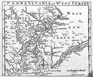
The Dutch defeated New Sweden in 1655. Settlement of the West Jersey area by Europeans was thin until the English conquest in 1664. Beginning in the late 1670s, Quakers settled in great numbers in this area, first in present-day Salem County and then in Burlington. The latter became the capital of West Jersey.[4]
Before 1674, land surveyors for New Jersey considered it as a hundred and partitioned it into Tenths. West Jersey comprised five of the Tenths. But demarcation of the boundaries awaited settlement, the quit-rents the settlers would pay, and the land surveying which the money would purchase. Thus it took years and multiple surveys to settle boundary disputes. Burlington County was formed on 17 May 1694 by combining "the first and second Tenths."[5] At least three expensive surveys were conducted of West Jersey. Richard Tindall was surveyor-general of Fenwick's Colony, the fifth Tenth.
Other sources
- Weslager, C. A. Dutch Explorers, Traders, and Settlers in the Delaware Valley, 1609-1644. (Philadelphia, University of Pennsylvania Press, 1961).
- Johnson, Amandus The Swedish Settlements on the Delaware Volume I: Their History and Relation to the Indians, Dutch and English, 1638-1664 (Philadelphia: Swedish Colonial Society. 1911)
References
- ↑ The Delaware Indians: A History, (by Weslager, C. A. New Brunswick, NJ: Rutgers University Press. 1972)
- ↑ The Swedes and Finns in New Jersey (Federal Writers' Projectejjejjdejje of WPA. Bayonne, New Jersey: Jersey Printing Company, Inc. 1938)
- ↑ A Brief History Of The Early Swedes in New Jersey (Gloucester County NJ History and Genealogy) http://www.nj.searchroots.com/Gloucesterco/swedesboro.htm
- ↑ British Colony (Burlington County Historical Society. Burlington City, NJ )
- ↑ Snyder, John P. The Story of New Jersey's Civil Boundaries: 1606-1968, Bureau of Geology and Topography; Trenton, New Jersey; 1969. p. 93. Accessed September 30, 2013.
External links
|
|---|
|
|
Early English colonial entities
|
 Category Category
|
|
|---|
|
|
North America |
|---|
| 17th century and before | 18th century | 19th and 20th century | | | | |
| |
|
|
Africa |
|---|
| 17th and 18th centuries | 19th century | 20th century | | | | |
| |
|
Asia |
|---|
| 17th and 18th century | 19th century | 20th century | | | | |
| |
|
Oceania |
|---|
| 18th and 19th centuries | 20th century | | | |
| |
|
Antarctica and South Atlantic |
|---|
|
- 14. Since 2009 part of Saint Helena, Ascension and Tristan da Cunha; Ascension Island (1922–) and Tristan da Cunha (1938–) were previously dependencies of Saint Helena.
- 15. Both claimed in 1908; territories formed in 1962 (British Antarctic Territory) and 1985 (South Georgia and the South Sandwich Islands).
|
|
|
Coordinates: 40°09′58″N 74°14′02″W / 40.166°N 74.234°W / 40.166; -74.234