Province of North-Carolina
| Province of North-Carolina | |||||||||
|---|---|---|---|---|---|---|---|---|---|
| 1712–1776 | |||||||||
|
Motto: Quae Sera Tamen Respexit "Which, though late, looked upon me" | |||||||||
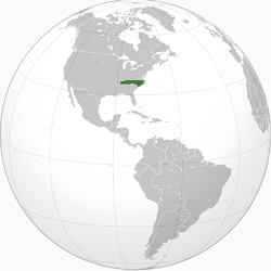 The Province of North-Carolina in 1776, prior to the American Revolutionary War | |||||||||
| Status | Colony of Great Britain | ||||||||
| Capital | |||||||||
| Official languages | English | ||||||||
| Government |
| ||||||||
| Monarch | |||||||||
• 1712–1714 | Anne | ||||||||
• 1714–1727 | George I | ||||||||
• 1727–1760 | George II | ||||||||
• 1760–1776 | George III | ||||||||
| Governor | |||||||||
• 1712 | Edward Hyde (first) | ||||||||
• 1771–1776 | Josiah Martin (last) | ||||||||
| Legislature | General Assembly | ||||||||
| Historical era | Georgian era | ||||||||
• Separation from Carolina | 24 January 1712 | ||||||||
| 4 July 1776 | |||||||||
| Currency | North Carolina pound | ||||||||
| |||||||||
| Today part of | |||||||||
.svg.png)
.svg.png)
The Province of North-Carolina was a British colony that existed in North America from 1712 to 1776, created as a proprietary colony. The power of the British government was vested in a Governor of North-Carolina, but the colony declared independence from Great Britain in 1776. The Province of North-Carolina had four capitals: Bath (1712–1722), Edenton (1722–1743), Brunswick (1743–1770), and New Bern (after 1770). The colony later became the states of North Carolina and Tennessee, and parts of the colony combined with other territory to form the states of Georgia, Alabama, and Mississippi.[1]
History
For history prior to 1712, see Province of Carolina.
King Charles II of England granted the Carolina charter in 1663 for land south of Virginia Colony and north of Spanish Florida. He granted the land to eight Lords Proprietors in return for their financial and political assistance in restoring him to the throne in 1660.[2] The northern half of the colony differed significantly from the southern half, and transportation and communication were difficult between the two regions, so a separate deputy governor was named to administer the northern half of the colony starting in 1691.[3]
The division of the colony into north and south was completed at a meeting of the Lords Proprietors held at Craven House[lower-alpha 1] in London on December 7, 1710, although the same proprietors continued to control both colonies. The first Governor of the separate North-Carolina province was Edward Hyde. Unrest against the proprietors in South Carolina in 1719 led King George I to appoint a royal governor in that colony, whereas the Lords Proprietor continued to appoint the governor of North-Carolina.[5] Both Carolinas became royal colonies in 1729, after the British government had tried for nearly 10 years locate and buy out seven of the eight Lords Proprietors. The remaining one-eighth share of the Province was retained by members of the Carteret family until 1776, part of North-Carolina known as the Granville District.[6]

Expansion westward began early in the 18th century from the province's seats of power on the coast, particularly after the conclusion of the Tuscarora and Yamasee wars, in which the largest barrier was removed to colonial settlement farther inland. Settlement in large numbers became more feasible over the Appalachian Mountains after the French and Indian War and the accompanying Anglo-Cherokee War, in which the Cherokee and Catawba tribes were effectively neutralized. King George III issued the Proclamation of 1763 in order to stifle potential conflict with Indians in that region, including the Cherokee. This barred any settlement near the headwaters of any rivers or streams that flowed westward towards the Mississippi River. It included several North-Carolina rivers, such as the French Broad River and Watauga River. This proclamation was not strictly obeyed and was widely detested in North Carolina, but it delayed migration to Tennessee until after the American Revolutionary War.[5]
Settlers continued to flow westwards in smaller numbers, despite the prohibition, and several trans-Appalachian settlements were formed. Most prominent was the Watauga Association, formed in 1772 as an independent territory within the bounds of North-Carolina which adopted its own written constitution. Notable frontiersmen such as Daniel Boone traveled back and forth across the invisible proclamation line as market hunters, seeking valuable pelts to sell in eastern settlements, and many served as leaders and guides for groups who settled in Tennessee and Kentucky.
Geography
Two important maps of the province were reproduced: one by Edward Moseley in 1733, and another by John Collet in 1770. Other maps exist dating to the early period of the Age of Discovery that depict portions of the province, or, more specifically, the coastline of the province along with that of South Carolina.[7]
Judiciary
The Court Act of 1746 established a supreme court, initially known as the General Court, which sat twice a year at New Bern, consisting of a Chief Justice and three Associate Justices.
- Chief Justices of the Supreme Court [8]
| Incumbent | Tenure | Notes | |
|---|---|---|---|
| Took office | Left office | ||
| Christopher Gale | 1703 | 1731 | interrupted by Tobias Knight and Frederick Jones |
| William Smith | 1 Apr 1731 | 1731 | left for England |
| John Palin | 1731 | 18 Oct 1732 | |
| William Little | 18 Oct 1732 | 1734 | died 1734 |
| Daniel Hanmer | 1734 | ||
| William Smith | 1740 | on return from England, died 1740 | |
| John Montgomery | 1740 | ||
| Edward Moseley | 1744 | 1749 | |
| Enoch Hall | 1749 | ||
| Eleazer Allen | 1749 | ||
| James Hasell | name also spelled Hazel or Hazell | ||
| Peter Henley | 1758 | died 1758 | |
| Charles Berry | 1760 | 1766 | committed suicide, 1766 |
| Martin Howard | 1767 | 1775 | Loyalist, forced to leave |
| 1773-1777 No Courts held | |||
See also
Notes
- ↑ Craven House, Drury Lane, London was named after William Craven, 1st Earl of Craven (1608–1697). The five storey house was demolished in 1809.[4]
References
- ↑ Lawson, John (1709). A New Voyage to Carolina. London. p. A2. Retrieved 13 February 2016.
- ↑ Danforth Prince (10 March 2011). Frommer's The Carolinas and Georgia. John Wiley & Sons. p. 11. ISBN 978-1-118-03341-8.
- ↑ Lawson, John (1709). A New Voyage to Carolina. London. pp. 239–254. Retrieved 13 February 2016.
- ↑ Wheatley, Cunningham (1891). London Past and Present. Volume 1 A-D. London: John Murray. p. 472. OCLC 832579536. Retrieved 10 May 2017.
- 1 2 Hugh T. Lefler and William S. Powell, Colonial North Carolina: A History (Charles Scribner's Sons, New York, 1973)
- ↑ Mitchell, Thornton W., "Granville Grant and District", Encyclopedia of North Carolina, William S. Powell, ed. (UNC Press, 2006)
- ↑ Richard A. Stephenson and William S. Powell. "Maps". NCPedia.org. North Carolina Government & Heritage Library. Retrieved December 13, 2012.
- ↑ "History of the Supreme Court of North Carolina" (PDF). Archived from the original (PDF) on February 21, 2016. Retrieved October 20, 2015.
Further reading
- Collet, Capt. John; Bayly, I. (1770). A Compleat map of North-Carolina from an actual Survey (Map). London: S. Hooper. Retrieved December 24, 2017 – via University of North Carolina at Chapel Hill.
External links
- Colonial Period at NCpedia (ncpedia.org)
- North Carolina Colony Facts at Softschools.com
| |||||||||||||||||||||||||||||||||||||||||||||||||||||||||||||||||||||||||||||||||||||||||||||