Fitzroy Falls, New South Wales
| Fitzroy Falls New South Wales | |||||||||||||||
|---|---|---|---|---|---|---|---|---|---|---|---|---|---|---|---|
 Fitzroy Falls | |||||||||||||||
|
Fitzroy Falls | |||||||||||||||
| Coordinates | 34°37′S 150°29′E / 34.617°S 150.483°ECoordinates: 34°37′S 150°29′E / 34.617°S 150.483°E | ||||||||||||||
| Population | 216 (2016 census)[1] | ||||||||||||||
| Postcode(s) | 2577 | ||||||||||||||
| Elevation | 822 m (2,697 ft)[2] | ||||||||||||||
| Location | |||||||||||||||
| LGA(s) | Wingecarribee Shire | ||||||||||||||
| Region | Southern Highlands | ||||||||||||||
| County | Camden | ||||||||||||||
| Parish | Yarrunga | ||||||||||||||
| State electorate(s) | Goulburn | ||||||||||||||
| Federal Division(s) | Whitlam | ||||||||||||||
| |||||||||||||||
Fitzroy Falls (postcode: 2577) is a village in the Wingecarribee Shire, located within the Southern Highlands region of New South Wales, Australia. The locality was known as Yarrunga,[3] but was renamed after the 81-metre (266 ft) waterfall. At the 2016 census, Fitzroy Falls had a population of 216.[1]
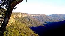
Waterfall
.jpg)
The waterfall was known to the indigenous Wodi Wodi people. The first European settler to see it was Charles Throsby, in the early 19th century.[4] Near the head of the Yarrunga Creek in the Morton National Park, the waterfall was named in honour of Sir Charles Fitzroy, the Governor of New South Wales during his visit to the area in 1850.[4]
While a town was planned for the area in the 1860s, little development occurred. With the advent of motor vehicles, Fitzroy Falls became, and still remains, a popular stopping point for tourists travelling towards the Southern Highlands. Substantial parking and catering facilities have been provided, together with pathways and boardwalks that enable able-bodied visitors to view the falls and other natural features.[5]
See also
References
- 1 2 Australian Bureau of Statistics (27 June 2017). "Fitzroy Falls (State Suburb)". 2016 Census QuickStats. Retrieved 25 July 2017.

- ↑ "Map of Fitzroy Falls, NSW". Digital Atlas Pty Limited. 2013. Retrieved 24 December 2013.
- ↑ "Fitzroy Falls (village)". Geographical Names Register (GNR) of NSW. Geographical Names Board of New South Wales. Retrieved 24 December 2013.
- 1 2 "Throsby's waterfalls a sight to behold". Southern Highland News. 10 December 2012. Retrieved 24 December 2013.
- ↑ "Fitzroy Falls Visitor Centre". National Parks & Wildlife Service. Government of New South Wales. Retrieved 24 December 2013.
External links
- "Fitzroy Falls Visitor Centre: Morton National Park". Office of Environment & Heritage. Government of New South Wales.
- "Fitzroy Falls Visitor Centre economic report". NSW Dept of Environment.
- "Fitzroy Falls - Morton National Park". The Southern Highlands of New South Wales. Furry Software Pty. Ltd. and Berrima District Historical and Family History Society. 15 June 2010.
- Village of Fitzroy Falls and adjoining lands [cartographic material] : Parishes - Burrawang & Yarrunga, County - Camden, Land District - Moss Vale, Shire - Wingecarribee / printed & published by Dept. of Lands, NSW Dept. of Lands, 1967