Balmoral, New South Wales (Southern Highlands)
| Balmoral New South Wales | |||||||||||||||
|---|---|---|---|---|---|---|---|---|---|---|---|---|---|---|---|
| Population | 426 (2016 census)[1] | ||||||||||||||
| Postcode(s) | 2571 | ||||||||||||||
| LGA(s) | Wingecarribee Shire | ||||||||||||||
| Region | Southern Highlands | ||||||||||||||
| County | Camden | ||||||||||||||
| Parish | Cumbertine | ||||||||||||||
| State electorate(s) | Wollondilly | ||||||||||||||
| Federal Division(s) | Hume | ||||||||||||||
| |||||||||||||||
Balmoral (/bælˈmɒrəl/) is a Northern Village of the Southern Highlands area of New South Wales, Australia. It is the northern most village in Wingecarribee Shire.
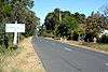
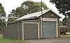
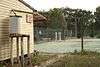
Balmoral Village lies mostly on the eastern side of Wilson Drive. The main street is Railway Parade. The village has no Post Office or shops. It has a well-maintained Village Hall, including a children's play area, and a tennis court. The village also has a NSW Rural Fire Service brigade. There is also an active Balmoral Village Association to run events and raise money for the little community.
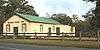
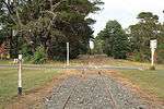
Balmoral was formerly a station on the alignment of the Main Southern railway line, and was known variously as 'Big Hill Lower Siding' (1878), 'Bargo' (1881), and 'Balmoral' (1888). On the New South Wales Government Railways Secretariat map, the locality was identified as Balmoral Private Village.[2] In 1919, the Picton-Mittagong Deviation opened. The Loop Line continued to operate until 1978, and is now disused. The Balmoral station building was re-erected adjacent to the old school house (built in 1893) and the Loopline Pottery is on the same property.
The town is now served on weekdays by the Bowral to Picton NSW TrainLink bus service that runs to the towns served by the old Main South railway alignment, between Mittagong and Picton. There are six services a day on this route. There is no accommodation here.
Gallery
- Balmoral Village

References
- ↑ Australian Bureau of Statistics (27 June 2017). "Balmoral (Wingecarribee - NSW)". 2016 Census QuickStats. Retrieved 11 July 2017.

- ↑ Bayley, W. A. 1973 Picton-Mittagong Loop-Line Railway. p. 22. Bulli: Austrail. ISBN 0-909597-14-6.
Coordinates: 34°18′55″S 150°31′04″E / 34.31528°S 150.51778°E