National Register of Historic Places listings in Wrangell, Alaska
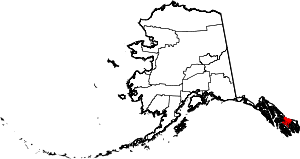
Location of Wrangell in Alaska
This is a list of the National Register of Historic Places listings in Wrangell, Alaska.
This is intended to be a complete list of the properties and districts on the National Register of Historic Places in Wrangell, Alaska, United States. The locations of National Register properties and districts for which the latitude and longitude coordinates are included below, may be seen in a Google map.[1]
There are 4 properties and districts listed on the National Register in the city and borough. Another property was once listed but has been removed.
- This National Park Service list is complete through NPS recent listings posted October 4, 2018.[2]
Current listings
| [3] | Name on the Register[4] | Image | Date listed[5] | Location | City or town | Description |
|---|---|---|---|---|---|---|
| 1 | Chief Shakes Historic Site | 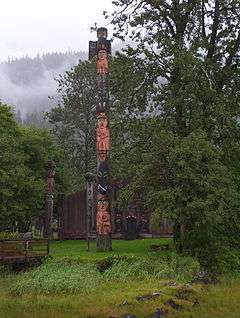 |
October 27, 1970 (#70000918) |
Shakes Island, inside Wrangell Harbor 56°27′57″N 132°22′50″W / 56.46571°N 132.38062°W |
Wrangell | |
| 2 | Etolin Canoe |  |
June 5, 1989 (#88001061) |
Head of Brunett Inlet, Etolin Island, Tongass National Forest 56°10′23″N 132°27′25″W / 56.17303°N 132.45701°W |
Wrangell | |
| 3 | Judith Ann (Riverboat) | July 7, 2004 (#04000658) |
Mile 12.25 of Zimovia Highway, about 10 miles (16 km) south of Wrangell, 56°19′22″N 132°20′48″W / 56.32285°N 132.34674°W |
Wrangell | ||
| 4 | Saint Philip's Episcopal Church | 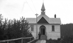 |
May 6, 1987 (#87000654) |
446 Church Street 56°28′11″N 132°22′43″W / 56.46979°N 132.37853°W |
Wrangell |
Former listing
| [3] | Name on the Register | Image | Date listed | Date removed | Location | City or town | Summary |
|---|---|---|---|---|---|---|---|
| 1 | Wrangell Public School | May 16, 1978 (#78003432) | May 10, 1996 | Corner of 2nd Street and Bevier Street 56°28′25″N 132°23′14″W / 56.47366°N 132.38723°W |
Wrangell | Originally the public school, became the town hall in 1931. Demolished in 1996. |
See also
| Wikimedia Commons has media related to National Register of Historic Places in Wrangell, Alaska. |
References
- ↑ The latitude and longitude information provided in this table was derived originally from the National Register Information System, which has been found to be fairly accurate for about 99% of listings. For about 1% of NRIS original coordinates, experience has shown that one or both coordinates are typos or otherwise extremely far off; some corrections may have been made. A more subtle problem causes many locations to be off by up to 150 yards, depending on location in the country: most NRIS coordinates were derived from tracing out latitude and longitudes from USGS topographical quadrant maps created under the North American Datum of 1927, which differs from the current, highly accurate WGS84 GPS system used by most on-line maps. Chicago is about right, but NRIS longitudes in Washington are higher by about 4.5 seconds, and are lower by about 2.0 seconds in Maine. Latitudes differ by about 1.0 second in Florida. Some locations in this table may have been corrected to current GPS standards.
- ↑ "National Register of Historic Places: Weekly List Actions". National Park Service, United States Department of the Interior. Retrieved on October 4, 2018.
- 1 2 Numbers represent an ordering by significant words. Various colorings, defined here, differentiate National Historic Landmarks and historic districts from other NRHP buildings, structures, sites or objects.
- ↑ National Park Service (2008-04-24). "National Register Information System". National Register of Historic Places. National Park Service.
- ↑ The eight-digit number below each date is the number assigned to each location in the National Register Information System database, which can be viewed by clicking the number.
| Topics | |
|---|---|
| Lists by states |
|
| Lists by insular areas | |
| Lists by associated states | |
| Other areas | |
| |
 | Boroughs | .svg.png) | |
Census areas | |||
There are no sites listed on the National Register of Historic Places in Kusilvak Census Area. | |||
Juneau (capital) | ||
| Topics |  | |
| Society | ||
| Regions | ||
| Largest cities pop. over 25,000 | ||
| Smaller cities pop. over 2,000 | ||
| Boroughs | ||
| Census Areas | ||
This article is issued from
Wikipedia.
The text is licensed under Creative Commons - Attribution - Sharealike.
Additional terms may apply for the media files.