National Register of Historic Places listings in Haines Borough, Alaska
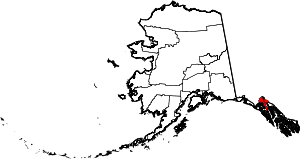
Location of the Haines Borough in Alaska
This is a list of the National Register of Historic Places listings in Haines Borough, Alaska.
This is intended to be a complete list of the properties and districts on the National Register of Historic Places in Haines Borough, Alaska, United States. The locations of National Register properties and districts for which the latitude and longitude coordinates are included below, may be seen in a Google map.[1]
There are 6 properties and districts listed on the National Register in the borough, including 1 National Historic Landmark.
- This National Park Service list is complete through NPS recent listings posted October 4, 2018.[2]
Current listings
| [3] | Name on the Register[4] | Image | Date listed[5] | Location | City or town | Description |
|---|---|---|---|---|---|---|
| 1 | Charlie Anway Cabin | September 14, 2001 (#01000967) |
Mile 1.5 on the Haines Highway 59°14′27″N 135°28′45″W / 59.24089°N 135.4793°W |
Haines | ||
| 2 | Eldred Rock Lighthouse | 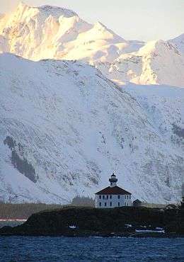 |
December 30, 1975 (#75000332) |
20 miles (32 km) south of Haines, east of Sullivan Island in Lynn Canal 58°58′15″N 135°13′13″W / 58.97096°N 135.22026°W |
Haines | |
| 3 | Fort William H. Seward | 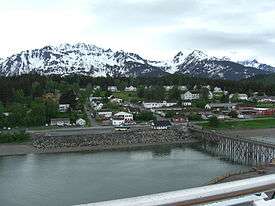 |
April 11, 1972 (#72000190) |
Port Chilkoot, about 0.5 miles (0.80 km) south of Haines, Alaska 59°13′37″N 135°26′38″W / 59.22705°N 135.44379°W |
Haines | |
| 4 | Government Indian School | February 8, 1980 (#80000756) |
1st Avenue, between Union Street and View Street. 59°14′16″N 135°26′35″W / 59.23768°N 135.44313°W |
Haines | ||
| 5 | Pleasant Camp | _IN_LATE_1920s_-_Dalton_Trail_Post%2C_Mile_40%2C_Haines_Highway%2C_Haines%2C_Ha_-_LOC_-_hhh.ak0001.photos.001415p.jpg) |
July 5, 1973 (#73000376) |
Mile 40 on the Haines Highway, near US-Canadian border 59°27′00″N 136°21′46″W / 59.45008°N 136.36282°W |
Haines | Also known as the Dalton Trail Camp, it was an outpost of the Canadian Northwest Mounted Police in the late 19th century. |
| 6 | Porcupine District | 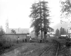 |
November 13, 1976 (#76000358) |
1 mile (1.6 km) southwest of Mile 35 of Haines Highway, across Klehini River 59°25′20″N 136°14′14″W / 59.4223°N 136.23714°W |
Haines | Mining camp mostly active in the early 20th century. |
See also
| Wikimedia Commons has media related to National Register of Historic Places in Haines Borough, Alaska. |
References
- ↑ The latitude and longitude information provided in this table was derived originally from the National Register Information System, which has been found to be fairly accurate for about 99% of listings. For about 1% of NRIS original coordinates, experience has shown that one or both coordinates are typos or otherwise extremely far off; some corrections may have been made. A more subtle problem causes many locations to be off by up to 150 yards, depending on location in the country: most NRIS coordinates were derived from tracing out latitude and longitudes from USGS topographical quadrant maps created under the North American Datum of 1927, which differs from the current, highly accurate WGS84 GPS system used by most on-line maps. Chicago is about right, but NRIS longitudes in Washington are higher by about 4.5 seconds, and are lower by about 2.0 seconds in Maine. Latitudes differ by about 1.0 second in Florida. Some locations in this table may have been corrected to current GPS standards.
- ↑ "National Register of Historic Places: Weekly List Actions". National Park Service, United States Department of the Interior. Retrieved on October 4, 2018.
- ↑ Numbers represent an ordering by significant words. Various colorings, defined here, differentiate National Historic Landmarks and historic districts from other NRHP buildings, structures, sites or objects.
- ↑ National Park Service (2008-04-24). "National Register Information System". National Register of Historic Places. National Park Service.
- ↑ The eight-digit number below each date is the number assigned to each location in the National Register Information System database, which can be viewed by clicking the number.
| Topics | |
|---|---|
| Lists by states |
|
| Lists by insular areas | |
| Lists by associated states | |
| Other areas | |
| |
 | Boroughs | .svg.png) | |
Census areas | |||
There are no sites listed on the National Register of Historic Places in Kusilvak Census Area. | |||
Municipalities and communities of Haines Borough, Alaska, United States | ||
|---|---|---|
| CDPs | | |
| Footnotes | ‡This populated place also has portions in adjacent boroughs or census areas | |
This article is issued from
Wikipedia.
The text is licensed under Creative Commons - Attribution - Sharealike.
Additional terms may apply for the media files.