National Register of Historic Places listings in Yukon–Koyukuk Census Area, Alaska
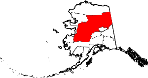
Location of the Yukon-Koyukuk Census Area in Alaska
This is a list of the National Register of Historic Places listings in Yukon–Koyukuk Census Area, Alaska.
This is intended to be a complete list of the properties and districts on the National Register of Historic Places in Yukon-Koyukuk Census Area, Alaska, United States. The locations of National Register properties and districts for which the latitude and longitude coordinates are included below, may be seen in a Google map.[1]
There are 16 properties and districts listed on the National Register in the census area. Another 2 properties were once listed but have been removed.
- This National Park Service list is complete through NPS recent listings posted October 4, 2018.[2]
Current listings
| [3] | Name on the Register[4] | Image | Date listed[5] | Location | City or town | Description |
|---|---|---|---|---|---|---|
| 1 | Ed Beiderman Fish Camp | 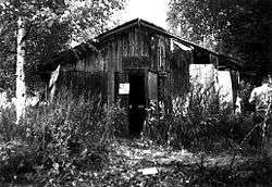 |
July 20, 1987 (#87001204) |
Left bank of Yukon River, about 56 miles (90 km) northwest of Eagle 65°22′34″N 142°32′18″W / 65.37623°N 142.53836°W |
Eagle | |
| 2 | Bettles Lodge | May 8, 1997 (#97000401) |
1 Airline Drive, Bettles Field 66°55′05″N 151°31′06″W / 66.91812°N 151.51843°W |
Bettles | ||
| 3 | Central House | July 31, 1978 (#78003431) |
Mile 128 of Steese Highway 65°34′21″N 144°47′56″W / 65.57238°N 144.79894°W |
Central | Building collapsed at an uncertain date and is no more standing.[lower-alpha 1] | |
| 4 | Christ Church Mission | 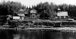 |
May 8, 1980 (#80004572) |
Corner of Main Road and River Road 62°39′20″N 160°12′11″W / 62.65563°N 160.20307°W |
Anvik | |
| 5 | Coal Creek Historic Mining District | 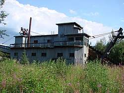 |
May 4, 1995 (#95000573) |
Along Coal Creek, about 44 miles (71 km) southeast of Circle 65°18′12″N 143°09′22″W / 65.30337°N 143.15598°W |
Circle | |
| 6 | George McGregor Cabin | 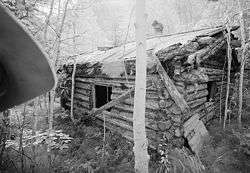 |
July 21, 1987 (#87001199) |
About 2 miles (3.2 km) west of Coal Creek 65°21′11″N 143°11′48″W / 65.35316°N 143.19669°W |
Eagle | |
| 7 | Mission Church | April 11, 1977 (#77001578) |
Main Street 68°07′44″N 145°32′18″W / 68.12901°N 145.53821°W |
Arctic Village | ||
| 8 | Nenana Depot | 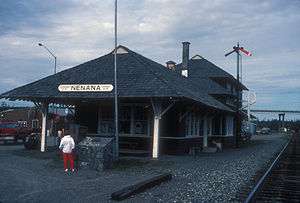 |
August 10, 1977 (#77000229) |
900 A Street 64°33′52″N 149°05′45″W / 64.56437°N 149.09589°W |
Nenana | Building now hosting the Alaska State Railroad Museum. |
| 9 | Old Mission House | November 7, 1978 (#78000539) |
Along Winter Trail 66°33′57″N 145°16′36″W / 66.56588°N 145.2768°W |
Fort Yukon | Building not standing anymore at its original location. It is unclear whether it has been destroyed or relocated elsewhere in Fort Yukon.[lower-alpha 2] | |
| 10 | Presentation of Our Lord Chapel | 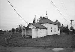 |
June 6, 1980 (#80004584) |
Along Telida Trail 63°00′45″N 154°22′35″W / 63.01256°N 154.3763°W |
Nikolai | |
| 11 | Ruby Roadhouse | May 20, 1982 (#82004898) |
On Olson Street, between Ruby-Poorman Drive and Sulatna Road 64°44′20″N 155°29′46″W / 64.73896°N 155.49604°W |
Ruby | ||
| 12 | Frank Slaven Roadhouse | .jpg) |
July 20, 1987 (#87001202) |
Mouth of Coal Creek, about 42 miles (68 km) southeast of Circle 65°21′02″N 143°07′22″W / 65.35045°N 143.12267°W |
Circle | |
| 13 | Sourdough Inn | December 30, 1997 (#97001585) |
Northwest corner of 1st Avenue and Sled Road 66°33′49″N 145°16′20″W / 66.5636°N 145.27231°W |
Fort Yukon | Building not standing anymore at its original location. It is unclear whether it has been destroyed or relocated elsewhere in Fort Yukon.[lower-alpha 2] | |
| 14 | Tanana Mission | .jpg) |
August 3, 1977 (#77000230) |
At end of Cemetery Road, about 2.5 miles (4.0 km) east of Tanana 65°10′28″N 151°59′47″W / 65.17446°N 151.99627°W |
Tanana | |
| 15 | Tolovana Roadhouse |  |
October 7, 1988 (#88000402) |
At the confluence of Tanana and Tolovana Rivers, about 29 miles (47 km) northwest of Nenana 64°51′13″N 149°49′29″W / 64.8537°N 149.82483°W |
Nenana | |
| 16 | Woodchopper Roadhouse | 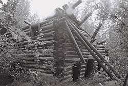 |
July 20, 1987 (#87001201) |
About 1 mile (1.6 km) east of Woodchopper Creek 65°21′22″N 143°18′17″W / 65.35604°N 143.30485°W |
Circle |
Former listings
| [3] | Name on the Register | Image | Date listed | Date removed | Location | City or town | Summary |
|---|---|---|---|---|---|---|---|
| 1 | Miller House | November 5, 1971 (#71001092) | November 6, 1971 | Mile 114.2, Steese Highway, about 12.5 miles (20.1 km) west of Central 65°31′25″N 145°13′30″W / 65.52366°N 145.22505°W |
Central | Destroyed by fire in 1970. | |
| 2 | James Taylor Cabins | July 20, 1987 (#87001203) | August 7, 2000 | North bank of the Yukon opposite Fourth of July Creek, about 34 miles (55 km) northwest of Eagle 65°12′40″N 141°47′10″W / 65.21107°N 141.78623°W |
Eagle | Destroyed by forest fire in 1999. |
See also
| Wikimedia Commons has media related to National Register of Historic Places in Yukon-Koyukuk Census Area, Alaska. |
Notes
- ↑ Building remains are still visible, shortly east of Crooked Creek bridge, on Streetview.
- 1 2 Compare modern satellite imagery with Old Mission House NRHP form containing a sketch map, this 1950 aerial image and this 1972 aerial image where the building is visible.
References
- ↑ The latitude and longitude information provided in this table was derived originally from the National Register Information System, which has been found to be fairly accurate for about 99% of listings. For about 1% of NRIS original coordinates, experience has shown that one or both coordinates are typos or otherwise extremely far off; some corrections may have been made. A more subtle problem causes many locations to be off by up to 150 yards, depending on location in the country: most NRIS coordinates were derived from tracing out latitude and longitudes from USGS topographical quadrant maps created under the North American Datum of 1927, which differs from the current, highly accurate WGS84 GPS system used by most on-line maps. Chicago is about right, but NRIS longitudes in Washington are higher by about 4.5 seconds, and are lower by about 2.0 seconds in Maine. Latitudes differ by about 1.0 second in Florida. Some locations in this table may have been corrected to current GPS standards.
- ↑ "National Register of Historic Places: Weekly List Actions". National Park Service, United States Department of the Interior. Retrieved on October 4, 2018.
- 1 2 Numbers represent an ordering by significant words. Various colorings, defined here, differentiate National Historic Landmarks and historic districts from other NRHP buildings, structures, sites or objects.
- ↑ National Park Service (2008-04-24). "National Register Information System". National Register of Historic Places. National Park Service.
- ↑ The eight-digit number below each date is the number assigned to each location in the National Register Information System database, which can be viewed by clicking the number.
| Topics | |
|---|---|
| Lists by states |
|
| Lists by insular areas | |
| Lists by associated states | |
| Other areas | |
| |
 | Boroughs | .svg.png) | |
Census areas | |||
There are no sites listed on the National Register of Historic Places in Kusilvak Census Area. | |||
Municipalities and communities of Yukon–Koyukuk Census Area, Alaska, United States | ||
|---|---|---|
| Cities | | |
| CDPs | ||
| Unincorporated communities | ||
| Ghost towns | ||
This article is issued from
Wikipedia.
The text is licensed under Creative Commons - Attribution - Sharealike.
Additional terms may apply for the media files.