| [3] |
Name on the Register |
Image |
Date listed[4] |
Location |
City or town |
Description |
|---|
| 1 |
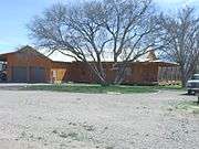
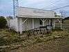
Ash Fork Maintenance Camp No. 1 |
|
March 2, 2000
(#00000103) |
Western end of old U.S. Route 66
35°13′22″N 112°29′28″W / 35.222778°N 112.491111°W / 35.222778; -112.491111 (Ash Fork Maintenance Camp No. 1) |
Ash Fork |
|
| 2 |
Beaver Creek Ranger Station |
|
June 10, 1993
(#93000512) |
Off Interstate 17 northeast of Rimrock in the Coconino National Forest
34°40′22″N 111°42′41″W / 34.672778°N 111.711389°W / 34.672778; -111.711389 (Beaver Creek Ranger Station) |
Rimrock |
|
| 3 |
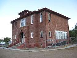
Beaver Creek School |
|
September 20, 2016
(#16000631) |
4810 E. Beaver Creek Rd.
34°39′14″N 111°46′02″W / 34.653974°N 111.767248°W / 34.653974; -111.767248 (Beaver Creek School) |
Rimrock |
|
| 4 |
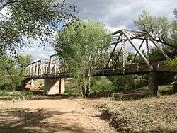
Broadway Bridge |
|
September 30, 1988
(#88001651) |
Broadway St. over Bitter Creek
34°46′27″N 112°03′19″W / 34.774167°N 112.055278°W / 34.774167; -112.055278 (Broadway Bridge) |
Clarkdale |
|
| 5 |
Building at 826 North Main Street |
|
September 19, 1986
(#86002147) |
826 N. Main St.
34°44′46″N 112°01′36″W / 34.746111°N 112.026667°W / 34.746111; -112.026667 (Building at 826 North Main Street) |
Cottonwood |
|
| 6 |
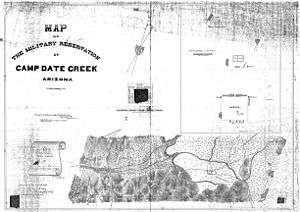
Camp Date Creek |
|
March 22, 1996
(#95001361) |
North of U.S. Route 89
34°15′45″N 112°55′24″W / 34.2625°N 112.923333°W / 34.2625; -112.923333 (Camp Date Creek) |
Date Creek |
Also known as Camp McPherson |
| 7 |
Childs-Irving Hydroelectric Facilities |
|
August 9, 1991
(#91001023) |
From the eastern bank of the Verde River northeast to Stehr Lake and along Fossil Creek in the Tonto National Forest
34°20′59″N 111°41′57″W / 34.349722°N 111.699167°W / 34.349722; -111.699167 (Childs-Irving Hydroelectric Facilities) |
Strawberry |
|
| 8 |
Clark Memorial Clubhouse |
|
October 29, 1982
(#82001662) |
Off N. 9th St.
34°46′20″N 112°03′20″W / 34.772222°N 112.055556°W / 34.772222; -112.055556 (Clark Memorial Clubhouse) |
Clarkdale |
|
| 9 |
Clarkdale Historic District |
|
January 8, 1998
(#97001586) |
Roughly along Main St., roughly bounded by the Verde River including industrial smelter site
34°46′27″N 112°03′31″W / 34.774167°N 112.058611°W / 34.774167; -112.058611 (Clarkdale Historic District) |
Clarkdale |
|
| 10 |
Clear Creek Church |
|
August 6, 1975
(#75000362) |
3.5 mi (5.6 km) southeast of Camp Verde
34°31′30″N 111°49′41″W / 34.525°N 111.828056°W / 34.525; -111.828056 (Clear Creek Church) |
Camp Verde |
|
| 11 |
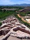
Clear Creek Pueblo and Caves |
|
February 10, 1975
(#75000363) |
Address Restricted
|
Camp Verde |
Sinagua pueblo |
| 12 |
Clemenceau Public School |
|
September 19, 1986
(#86002149) |
1 N. Willard St.
34°44′24″N 112°01′33″W / 34.74°N 112.025833°W / 34.74; -112.025833 (Clemenceau Public School) |
Cottonwood |
Now Clemenceau Heritage Museum |
| 13 |
Copper Creek Guard Station |
|
June 10, 1993
(#93000525) |
Northeast of Black Canyon City in the Tonto National Forest
34°12′51″N 111°58′40″W / 34.214167°N 111.977778°W / 34.214167; -111.977778 (Copper Creek Guard Station) |
Black Canyon City |
|
| 14 |
Cottage Hotel |
|
February 12, 1998
(#98000080) |
Junction of 1st St. and Shoeny Ave.
35°19′40″N 112°52′35″W / 35.327778°N 112.876389°W / 35.327778; -112.876389 (Cottage Hotel) |
Seligman |
|
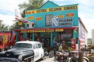
| 15 |
Cottonwood Commercial Historic District |
|
May 18, 2000
(#00000497) |
Approximately from 712 to 1124 N. Main St.
34°44′52″N 112°01′36″W / 34.747778°N 112.026667°W / 34.747778; -112.026667 (Cottonwood Commercial Historic District) |
Cottonwood |
|
| 16 |
Cross Creek Ranch House |
|
May 29, 2008
(#08000461) |
10 Russet Ridge Pl.
34°48′53″N 111°50′14″W / 34.814614°N 111.837173°W / 34.814614; -111.837173 (Cross Creek Ranch House) |
Sedona |
|
| 17 |
Crown King Ranger Station |
|
June 10, 1993
(#93000522) |
West of Crown King in the Prescott National Forest
34°12′22″N 112°20′27″W / 34.206111°N 112.340833°W / 34.206111; -112.340833 (Crown King Ranger Station) |
Crown King |
|
| 18 |
Edens House |
|
September 19, 1986
(#86002150) |
1015 N. Cactus St.
34°44′54″N 112°01′38″W / 34.748333°N 112.027222°W / 34.748333; -112.027222 (Edens House) |
Cottonwood |
|
| 19 |
Fewke's Fort Below Aztec Pass (AR-03-09-06-23) |
|
January 20, 1989
(#88003186) |
Address Restricted
|
Paulden |
Prescott Culture archaeological site |
| 20 |
Fort Verde District |
|
October 7, 1971
(#71000120) |
Bounded by Hance, Coppinger, and Woods Sts.; also roughly north and east of Hance and Coppinger Sts. to Verde Ditch
34°33′54″N 111°51′08″W / 34.565°N 111.852222°W / 34.565; -111.852222 (Fort Verde District) |
Camp Verde |
Fort Verde State Historic Park and vicinity. Second set of addresses represents a boundary increase. |
| 21 |
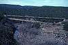
Fossil Creek Bridge |
|
September 30, 1988
(#88001620) |
Forest Service Rd. over Fossil Creek
34°23′39″N 111°37′45″W / 34.394167°N 111.629167°W / 34.394167; -111.629167 (Fossil Creek Bridge) |
Camp Verde |
|
| 22 |
Groom Creek School |
|
November 18, 1992
(#92001568) |
Senator Highway southeast of Prescott in the Prescott National Forest
34°28′15″N 112°26′02″W / 34.470833°N 112.433889°W / 34.470833; -112.433889 (Groom Creek School) |
Groom Creek |
|
| 23 |
Hatalacva Ruin |
|
July 24, 1974
(#74000463) |
Address Restricted
|
Clarkdale |
Sinagua ruin |
| 24 |
Hell Canyon Bridge |
|
September 30, 1988
(#88001682) |
Abandoned U.S. Route 89 over Hell Canyon
34°58′45″N 112°22′54″W / 34.979167°N 112.381667°W / 34.979167; -112.381667 (Hell Canyon Bridge) |
Drake |
|
| 25 |
Hyde Mountain Lookout House |
|
January 28, 1988
(#87002491) |
Prescott National Forest
34°50′15″N 112°55′10″W / 34.8375°N 112.919444°W / 34.8375; -112.919444 (Hyde Mountain Lookout House) |
Camp Wood |
|
| 26 |
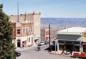
Jerome Historic District |
|
November 13, 1966
(#66000196) |
Jerome
34°45′16″N 112°06′45″W / 34.754444°N 112.1125°W / 34.754444; -112.1125 (Jerome Historic District) |
Jerome |
|
| 27 |
Kay-El-Bar Ranch |
|
May 22, 1978
(#78000572) |
North of Wickenburg on Rincon Rd.
34°00′34″N 112°44′53″W / 34.009444°N 112.748056°W / 34.009444; -112.748056 (Kay-El-Bar Ranch) |
Wickenburg |
Guest ranch |
| 28 |
Kirkland Store |
|
October 1, 1998
(#98001215) |
Main St. at the corner of Iron Springs Rd. and Kirkland Junction Rd.
34°25′01″N 112°42′32″W / 34.416944°N 112.708889°W / 34.416944; -112.708889 (Kirkland Store) |
Kirkland |
|
| 29 |
Little Hell Canyon Bridge |
|
September 30, 1988
(#88001684) |
Abandoned U.S. Route 89 over Little Hell Canyon
35°04′48″N 112°24′22″W / 35.08°N 112.406111°W / 35.08; -112.406111 (Little Hell Canyon Bridge) |
Drake |
|
| 30 |
Loy Butte Pueblo |
|
February 10, 1975
(#75000367) |
Address Restricted
|
Sedona |
Sinagua ruin |
| 31 |
Lynx Creek Bridge |
|
September 30, 1988
(#88001641) |
just east of Lynx Creek Road on the Old Black Canyon Highway
34°33′08″N 112°22′21″W / 34.552222°N 112.3725°W / 34.552222; -112.3725 (Lynx Creek Bridge) |
Prescott Valley |
|
| 32 |
Lynx Creek District |
|
August 31, 1978
(#78000571) |
south of Arizona State Route 69 and east of Stoneridge Drive
34°34′28″N 112°20′50″W / 34.574444°N 112.347222°W / 34.574444; -112.347222 (Lynx Creek District) |
Prescott Valley |
|
| 33 |
Master Mechanic's House |
|
September 19, 1986
(#86002152) |
333 S. Willard St.
34°44′00″N 112°01′33″W / 34.733333°N 112.025833°W / 34.733333; -112.025833 (Master Mechanic's House) |
Cottonwood |
UVX smelter complex |
| 34 |
Mayer Apartments |
|
July 13, 1989
(#89000860) |
Central Ave., southwest of Ash St.
34°23′54″N 112°14′01″W / 34.398333°N 112.233611°W / 34.398333; -112.233611 (Mayer Apartments) |
Mayer |
|
| 35 |
Mayer Business Block |
|
July 13, 1989
(#89000859) |
Oak St. and Central Ave.
34°23′54″N 112°13′57″W / 34.398333°N 112.2325°W / 34.398333; -112.2325 (Mayer Business Block) |
Mayer |
|
| 36 |
Mayer Red Brick Schoolhouse |
|
July 21, 2004
(#04000719) |
Main St.
34°24′N 112°14′W / 34.4°N 112.24°W / 34.4; -112.24 (Mayer Red Brick Schoolhouse) |
Mayer |
|
| 37 |
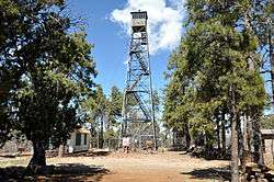
Mingus Lookout Complex |
|
January 28, 1988
(#87002490) |
Prescott National Forest
34°41′39″N 112°07′38″W / 34.694167°N 112.127222°W / 34.694167; -112.127222 (Mingus Lookout Complex) |
Jerome |
Fire tower and ranger cabin on Mingus Mountain |
| 38 |
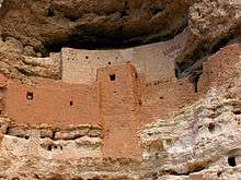
Montezuma Castle National Monument-Back Ranch Historic District-Montezuma Well Unit |
|
October 15, 1966
(#66000082) |
5525 Beaver Creek Rd., 40 mi (64 km) south of Flagstaff on Interstate 17
34°38′19″N 111°47′17″W / 34.638611°N 111.788056°W / 34.638611; -111.788056 (Montezuma Castle National Monument-Back Ranch Historic District-Montezuma Well Unit) |
Camp Verde |
Major Sinagua cliff dwelling |
| 39 |
OK Ranch Historic District |
|
April 19, 2018
(#100002358) |
Red Rock Crossing, Sedona Ranger District
34°49′35″N 111°48′33″W / 34.826488°N 111.809046°W / 34.826488; -111.809046 (OK Ranch Historic District) |
Coconino National Forest |
AKA Crescent Moon Ranch |
| 40 |
Palace Station District |
|
April 30, 1976
(#76000382) |
23 mi (37 km) south of Prescott in the Prescott National Forest
34°22′35″N 112°24′32″W / 34.376389°N 112.408889°W / 34.376389; -112.408889 (Palace Station District) |
Prescott National Forest |
Stagecoach station, built 1874 |
| 41 |
Pecan Lane Rural Historic Landscape |
|
May 11, 2000
(#00000463) |
537 to 867 Montezuma Castle Highway
34°34′47″N 111°51′12″W / 34.579722°N 111.853333°W / 34.579722; -111.853333 (Pecan Lane Rural Historic Landscape) |
Camp Verde |
|
| 42 |
Peeples Valley School |
|
September 26, 2007
(#07000991) |
18205 U.S. Route 89
34°17′03″N 112°43′17″W / 34.284167°N 112.721389°W / 34.284167; -112.721389 (Peeples Valley School) |
Peeples Valley |
|
| 43 |
Perkinsville Bridge |
|
March 31, 1989
(#88001671) |
Perkinsville-Williams Rd. over the Verde River
34°53′43″N 112°12′18″W / 34.895278°N 112.205°W / 34.895278; -112.205 (Perkinsville Bridge) |
Perkinsville |
South of Ash Fork |
| 44 |
Perry Mesa Archeological District |
|
November 20, 1975
(#75000364) |
Address Restricted
|
Black Canyon City |
Located on Agua Fria National Monument |
| 45 |
Poland Tunnel |
|
March 29, 1978
(#78000570) |
West of Poland off State Route 69
34°26′48″N 112°22′23″W / 34.446667°N 112.373056°W / 34.446667; -112.373056 (Poland Tunnel) |
Poland |
|
| 46 |
Rock House |
|
December 19, 1994
(#94001489) |
Pine Tree Ln. northwest of Groom Creek
34°29′21″N 112°26′45″W / 34.489167°N 112.445833°W / 34.489167; -112.445833 (Rock House) |
Groom Creek |
|
| 47 |
Sacred Mountain |
|
March 4, 1975
(#75000366) |
Address Restricted
|
Rimrock |
Sinagua archaeological site |
| 48 |
Santa Fe, Prescott & Phoenix Railway, Limestone Canyon District |
|
December 13, 1994
(#94000031) |
Address Restricted
|
Ash Fork and Chino Valley |
|
| 49 |
Seligman Commercial Historic District |
|
February 1, 2005
(#04000511) |
Roughly bounded by 1st and Lamport Sts. and Picacho and Railroad Aves.
35°19′35″N 112°52′27″W / 35.326389°N 112.874167°W / 35.326389; -112.874167 (Seligman Commercial Historic District) |
Seligman |
|
| 50 |
Smelter Machine Shop |
|
September 19, 1986
(#86002154) |
360 S. 6th St.
34°43′59″N 112°01′23″W / 34.733056°N 112.023056°W / 34.733056; -112.023056 (Smelter Machine Shop) |
Cottonwood |
|
| 51 |
Superintendent's Residence |
|
October 14, 1986
(#86002159) |
315 S. Willard
34°44′01″N 112°01′33″W / 34.733611°N 112.025833°W / 34.733611; -112.025833 (Superintendent's Residence) |
Cottonwood |
UVX smelter complex |
| 52 |
Sycamore Cliff Dwelling |
|
September 28, 1990
(#90001455) |
Address Restricted
|
Sedona |
Sinagua ruins |
| 53 |
Sycamore Ranger Station |
|
June 10, 1993
(#93000523) |
Forest Rd. 68F southwest of Camp Verde in the Prescott National Forest
34°21′07″N 111°58′08″W / 34.351944°N 111.968889°W / 34.351944; -111.968889 (Sycamore Ranger Station) |
Camp Verde |
|
| 54 |
Tuzigoot Museum |
|
September 9, 2010
(#10000518) |
Alternate US 89A and Tuzigoot Rd.
34°46′13″N 112°01′36″W / 34.770278°N 112.026667°W / 34.770278; -112.026667 (Tuzigoot Museum) |
Clarkdale |
Sinagua artifacts at the national monument |
| 55 |
Tuzigoot National Monument Archeological District |
|
October 15, 1966
(#66000194) |
Address Restricted
|
Clarkdale |
Large Sinagua pueblo |
| 56 |
UVX Smelter Operations Complex |
|
September 19, 1986
(#86002164) |
361 S. Willard
34°43′57″N 112°01′34″W / 34.7325°N 112.026111°W / 34.7325; -112.026111 (UVX Smelter Operations Complex) |
Cottonwood |
Copper smelter buildings from 1917–36 |
| 57 |
Verde River Bridge |
|
September 30, 1988
(#88001639) |
2.7 mi (4.3 km) south of Paulden on Sullivan Lake Rd.
34°51′50″N 112°27′34″W / 34.863889°N 112.459444°W / 34.863889; -112.459444 (Verde River Bridge) |
Paulden |
|
| 58 |
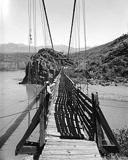
Verde River Sheep Bridge |
|
November 21, 1978
(#78000569) |
North of Carefree on the Verde River
34°04′39″N 111°42′26″W / 34.0775°N 111.707222°W / 34.0775; -111.707222 (Verde River Sheep Bridge) |
Carefree |
Demolished 1988 |
| 59 |
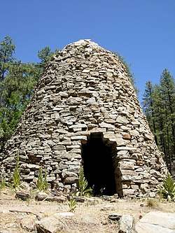
Walker Charcoal Kiln |
|
October 8, 1976
(#76000383) |
Southeast of Prescott in the Prescott National Forest
34°27′30″N 112°22′31″W / 34.458333°N 112.375278°W / 34.458333; -112.375278 (Walker Charcoal Kiln) |
Potato Patch |
|
| 60 |
Walnut Creek Bridge |
|
March 31, 1989
(#88001673) |
Forest Service Rd. over Walnut Creek
34°55′44″N 112°48′55″W / 34.928889°N 112.815278°W / 34.928889; -112.815278 (Walnut Creek Bridge) |
Simmons |
|
| 61 |
Walnut Creek Ranger Station |
|
June 10, 1993
(#93000524) |
Northwest of Prescott in the Prescott National Forest
34°55′28″N 112°50′24″W / 34.924444°N 112.84°W / 34.924444; -112.84 (Walnut Creek Ranger Station) |
Simmons |
|
| 62 |
Walnut Grove Bridge |
|
September 30, 1988
(#88001637) |
3.5 mi (5.6 km) northwest of Walnut Grove on Wagoner Rd.
34°18′37″N 112°34′05″W / 34.310278°N 112.568056°W / 34.310278; -112.568056 (Walnut Grove Bridge) |
Walnut Grove |
|
| 63 |
Willard House |
|
September 19, 1986
(#86002166) |
114 N. Main
34°45′01″N 112°01′43″W / 34.750278°N 112.028611°W / 34.750278; -112.028611 (Willard House) |
Cottonwood |
Queen Anne built in 1890 for Mary Willard, early settler |
| 64 |
Hank and Myrtle Wingfield Homestead |
|
July 27, 1999
(#99000857) |
806 E. Quarterhorse Ln.
34°32′07″N 111°50′27″W / 34.535278°N 111.840833°W / 34.535278; -111.840833 (Hank and Myrtle Wingfield Homestead) |
Camp Verde |
|
| 65 |
Robert W. Wingfield House |
|
February 3, 1986
(#86000146) |
Montezuma Castle Highway
34°34′55″N 111°51′09″W / 34.581944°N 111.8525°W / 34.581944; -111.8525 (Robert W. Wingfield House) |
Camp Verde |
|
| 66 |
Woolsey Ranchhouse Ruins |
|
November 7, 1977
(#77000240) |
North of Humboldt off State Route 69
34°30′43″N 112°13′52″W / 34.511944°N 112.231111°W / 34.511944; -112.231111 (Woolsey Ranchhouse Ruins) |
Humboldt |
King Woolsey's ranch, circa 1870 |
.jpg)
.jpg)
.jpg)

.jpg)
.jpg)
.jpg)

.jpg)


.jpg)
.jpg)