Iron Springs, Arizona
| Iron Springs, Arizona | |
|---|---|
| Unincorporated community | |
 Iron Springs, Arizona Location within the state of Arizona  Iron Springs, Arizona Iron Springs, Arizona (the US) | |
| Coordinates: 34°35′5″N 112°34′12″W / 34.58472°N 112.57000°WCoordinates: 34°35′5″N 112°34′12″W / 34.58472°N 112.57000°W | |
| Country | United States |
| State | Arizona |
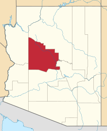
| County | Yavapai |
| Elevation | 6,073 ft (1,851 m) |
| Time zone | UTC-7 (Mountain (MST)) |
| ZIP codes | 86330 |
| GNIS feature ID | 30427[1] |
Iron Springs (also Ironsprings) is an unincorporated community in central Yavapai County, Arizona, United States, in the Prescott National Forest. It lies along Iron Springs Road northwest of the city of Prescott, the county seat of Yavapai County.[2] Its elevation is 6,073 feet (1,851 m).[1] Although Iron Springs is unincorporated, it has a post office, with the ZIP code of 86330.[3]
Originally summer homes, it continues to be a summer retreat.
Climate
According to the Köppen Climate Classification system, Iron Springs has a semi-arid climate, abbreviated "BSk" on climate maps.[4]
References
- 1 2 "Iron Springs, Arizona". Geographic Names Information System. United States Geological Survey.
- ↑ Rand McNally. The Road Atlas '08. Chicago: Rand McNally, 2008, p. 8.
- ↑ Zip Code Lookup
- ↑ Climate Summary for Iron Springs, Arizona
This article is issued from
Wikipedia.
The text is licensed under Creative Commons - Attribution - Sharealike.
Additional terms may apply for the media files.