National Highways of Pakistan
| National Highways of Pakistan پاکستان کی قومی شاہراہ | |
|---|---|
| System information | |
| Maintained by National Highway Authority | |
| Length | 12,131 km (7,538 mi) |
| Formed | 1988 |
| Highway names | |
| System links | |
| Roads in Pakistan | |
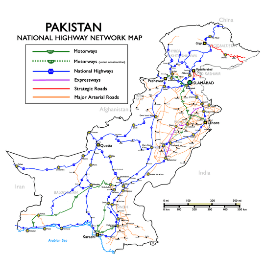
National Highways of Pakistan (Urdu: پاکستان کی قومی شاہراہ) are a network of toll highways in Pakistan, which are owned, maintained and operated by the National Highways Authority under the Ministry of Communications. It maintains 12,131 kilometres (7,538 mi) of roadways organized into various classifications which crisscross the country and provide access to major population centers. National Highways are not to be confused with provincial highways, which are roads maintained by the respective provinces. Pakistan's national highways include the famous Grand Trunk Road, Indus Highway, Karakoram Highway and Makran Coastal Highway. All national highways in Pakistan are pre-fixed with the letter 'N' (for "national") followed by the unique numerical designation of the specific highway (with a hyphen in the middle), e.g. "N-5". Each numerical designation is separated by five numerals, i.e. N-5, N-10, N-15, etc. National Highways are distinct from Strategic Highways, which begin with the prefix 'S' and are controlled and operated by the Ministry of Defence.
List of National Highways
| Sign | Course | Length | Lanes | Completion Year | Status | Remarks |
|---|---|---|---|---|---|---|
| Karachi – Torkham (N-5 National Highway) |
1819 km | 4 | 1952 | Operational | Longest national highway in Pakistan. Continues as Kabul–Torkham Road in Afghanistan. | |
| Karachi – Gwadar (N-10 National Highway) |
653 km | 2 | 2003 | Operational | Known more popularly as the Makran Coastal Highway. | |
| Mansehra – Chilas (N-15 National Highway) |
240 km | 2 | - | Operational | ||
| Karachi – Chaman (N-25 National Highway) |
813 km | 2 | - | Operational | Continues as Kandahar–Spin Boldak Road in Afghanistan. | |
| Basima – Khuzdar (N-30 National Highway) |
110 km | 2 | - | Operational | ||
| Hasan Abdal – Khunjerab Pass (N-35 National Highway) |
806 km | 2 | 1979 | Operational | Known more popularly as the Karakoram Highway Continues as China National Highway 314 | |
| Quetta – Taftan (N-40 National Highway) |
610 km | 2 | - | Operational | Continues as Road 84 | |
| Nowshera – Chitral (N-45 National Highway) |
309 km | 2 | - | Operational | ||
| Kuchlak – Dera Ismail Khan (N-50 National Highway) |
531 km | 2 | - | Operational | ||
| Kotri – Peshawar (N-55 National Highway) |
1264 km | 4 | - | Operational | Runs along the length of the Indus River, providing relief to the N-5. | |
| Sibi – Sukkur (N-65 National Highway) |
385 km | 2 | - | Operational | ||
| Qila Saifullah – Multan (N-70 National Highway) |
447 km | 2 | - | Operational | ||
| Islamabad – Kohala (N-75 National Highway) |
138 km | 4 | - | Operational | ||
| Islamabad – Kohat (N-80 National Highway) |
146 km | 2 | - | Operational | ||
| Hushab – Surab (N-85 National Highway) |
487 km | 2 | - | Operational | ||
| Khwazakhela – Besham (N-90 National Highway) |
64 km | 2 | - | Operational | ||
| Chakdara – Kalam (N-95 National Highway) |
135 km | 2 | - | Operational | ||
| Larkana – Lakhi (N-105 National Highway) |
61 km | 2 | - | Operational | ||
| Gharo – Keti Bunder (N-110 National Highway) |
90 km | 2 | - | Operational | ||
| Hyderabad – Khokhrapar (N-120 National Highway) |
220 km | 2 | - | Operational | ||
| Taxila – Haripur (N-125 National Highway) |
44 km | 2 | - | Operational | ||
| Larkana - Mohenjo Daro (N-155 National Highway) |
28 km | 2 | - | Operational | ||
| Larkana - Nasirabad (N-255 National Highway) |
34 km | 2 | - | Operational | ||
| Sakrand - Nawabshah (N-305 National Highway) |
35 km | 2 | - | Operational | ||
| Larkana - Shahdadkot (N-455 National Highway) |
50 km | 2 | - | Operational | ||
| Ratodero - Naudero (N-655 National Highway) |
18 km | 2 | - | Operational | ||
List of Strategic Highways
| Name | Course | Length | Lanes | Completion Year | Status | Remarks |
|---|---|---|---|---|---|---|
| S-1 | Gilgit - Skardu | 167 km | 2 | 1982 | Operational | |
| S-2 | Kohala - Muzaffarabad | 40 km | 2 | 2016 | Operational | |
| S-3 | Muzaffarabad - Chakothi | 55 km | 2 | 2010 | Operational | |
National Highway Network Map
See also
External links
| National Highways | ||
|---|---|---|
| Strategic Highways | ||
| National Highways |
| |||||
|---|---|---|---|---|---|---|
| Motorways | ||||||
| Expressways | ||||||
| Provincial Highways | ||||||