Nasukarasuyama
| Nasukarasuyama 那須烏山市 | |||
|---|---|---|---|
| City | |||
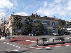 Nasukarasuyama City Hall | |||
| |||
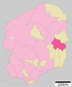 Location of Nasukarasuyama in Tochigi Prefecture | |||
 Nasukarasuyama | |||
| Coordinates: 36°39′24.8″N 140°9′5.1″E / 36.656889°N 140.151417°ECoordinates: 36°39′24.8″N 140°9′5.1″E / 36.656889°N 140.151417°E | |||
| Country | Japan | ||
| Region | Kantō | ||
| Prefecture | Tochigi Prefecture | ||
| Area | |||
| • Total | 174.35 km2 (67.32 sq mi) | ||
| Population (May 2015) | |||
| • Total | 27,059 | ||
| • Density | 155/km2 (400/sq mi) | ||
| Time zone | UTC+9 (Japan Standard Time) | ||
| - Tree | Zelkova serrata | ||
| - Flower | Magnolia kobus | ||
| - Bird | Crow | ||
| Phone number | 0287-83-1111 | ||
| Address | 1-1-1 Chuo, Nasukarasuyama-shi, Tochigi-ken 321-0692 | ||
| Website | http://www.city.nasukarasuyama.lg.jp/ | ||


Nasukarasuyama (那須烏山市 Nasukarasuyama-shi) is a city located in Tochigi Prefecture, Japan. As of May 2015, the city had an estimated population of 27,059, and a population density of 155 persons per km². Its total area is 174.35 km².
History
The area began as a castle town for Karasuyama Domain in the Edo period, centered on Karasuyama Castle, a fortification dating to the Kamakura period. Karasuyama Town was established with the creation of the municipalities system on April 1, 1889. It merged with the neighboring villages of Mukada, Sakai, and Nanago on March 31, 1954. The modern city of Nasukarasuyama was established on October 1, 2005, from the merger of the towns of Karasuyama and Minaminasu (both from Nasu District).
Geography
Nasukarasuyama is located in the eastern of Tochigi Prefecture.
Surrounding municipalities
| Climate data for Nsukarasuyama (2010) | |||||||||||||
|---|---|---|---|---|---|---|---|---|---|---|---|---|---|
| Month | Jan | Feb | Mar | Apr | May | Jun | Jul | Aug | Sep | Oct | Nov | Dec | Year |
| Record high °C (°F) | 17.0 (62.6) |
18.5 (65.3) |
20.9 (69.6) |
24.4 (75.9) |
30.0 (86) |
31.0 (87.8) |
37.3 (99.1) |
35.5 (95.9) |
35.2 (95.4) |
28.1 (82.6) |
21.8 (71.2) |
— | 37.3 (99.1) |
| Average high °C (°F) | 9.5 (49.1) |
8.7 (47.7) |
11.6 (52.9) |
15.6 (60.1) |
22.4 (72.3) |
27.2 (81) |
31.2 (88.2) |
32.5 (90.5) |
27.9 (82.2) |
21.1 (70) |
16.6 (61.9) |
— | — |
| Average low °C (°F) | −6.1 (21) |
−2.8 (27) |
0.4 (32.7) |
4.1 (39.4) |
10.3 (50.5) |
16.4 (61.5) |
21.8 (71.2) |
22.9 (73.2) |
18.1 (64.6) |
11.9 (53.4) |
2.5 (36.5) |
— | — |
| Record low °C (°F) | −10.3 (13.5) |
−8.8 (16.2) |
−5.1 (22.8) |
−2.4 (27.7) |
2.7 (36.9) |
7.0 (44.6) |
18.9 (66) |
20.3 (68.5) |
7.6 (45.7) |
1.6 (34.9) |
−2.3 (27.9) |
— | −10.3 (13.5) |
| Average precipitation mm (inches) | 1.0 (0.039) |
75.0 (2.953) |
123.0 (4.843) |
189.0 (7.441) |
179.0 (7.047) |
206.0 (8.11) |
189.0 (7.441) |
23.0 (0.906) |
270.0 (10.63) |
161.5 (6.358) |
57.0 (2.244) |
— | — |
| Source: 気象庁[1] | |||||||||||||
Education
- Nasukarasuyama has 6 primary schools, two middle schools and one high school.
Transportation
Railway
- JR East – Karasuyama Line
- Kōnoyama - Ōgane - Kobana - Taki - Karasuyama
Highway
Local attractions
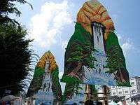
- Yamaage Kaikan
- Karasuyama Castle
References
- ↑ "那須烏山 2010年". Japan Meteorological Agency. Retrieved 2010-12-18.
External links
![]()
- Official Website (in Japanese)
| Core city | ||
|---|---|---|
| Cities | ||
| Districts | ||
| Authority control |
|---|