Ichikai, Tochigi
| Ichikai 市貝町 | ||
|---|---|---|
| Town | ||
 Ichikai Town Office | ||
| ||
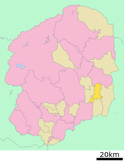 Location of Ichikai in Tochigi Prefecture | ||
 Ichikai | ||
| Coordinates: 36°33′N 140°06′E / 36.550°N 140.100°ECoordinates: 36°33′N 140°06′E / 36.550°N 140.100°E | ||
| Country | Japan | |
| Region | Kantō | |
| Prefecture | Tochigi Prefecture | |
| District | Haga | |
| Area | ||
| • Total | 64.25 km2 (24.81 sq mi) | |
| Population (May 2015) | ||
| • Total | 11,664 | |
| • Density | 182/km2 (470/sq mi) | |
| Time zone | UTC+9 (Japan Standard Time) | |
| - Tree | Cryptomeria | |
| - Flower | Chrysanthemum | |
| - Bird | Oriental turtle dove | |
| Phone number | 0285-68-1111 | |
| Address | Ōaza Ichikai 1280, Ichikai-machi, Haga-gun, Tochigi-ken 321-3493 | |
| Website | http://www.town.ichikai.tochigi.jp/ | |

Ichikai (市貝町 Ichikai-machi) is a town located in Tochigi Prefecture, Japan. As of May 2015, the town had an estimated population of 11,664, and a population density of 182 persons per km². Its total area is 64.25 km².
Geography
Ichikai is located in eastern Tochigi Prefecture.
Surrounding municipalities
History
Ichihane and Kokai villages were created within Haga District on April 1, 1889 with the creation of the municipalities system. The two villages merged to form Ichikai village on May 3, 1954. Ichikai was elevated to town status on January 1, 1972.
Economy
The economy of Ichikai is heavily dependent on agriculture. It is also a bedroom community for nearby Utsunomiya, Mooka and Haga.
Education
Ichikai has three primary schools and one middle school.
Transportation
Railway
Highway
External links
![]()
- Official Website (in Japanese)
| Core city | ||
|---|---|---|
| Cities | ||
| Districts | ||