Ōtawara
| Ōtawara 大田原市 | |||
|---|---|---|---|
| City | |||
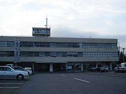 Ōtawara City Hall | |||
| |||
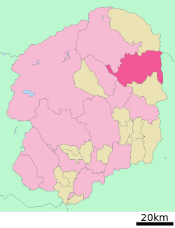 Location of Ōtawara in Tochigi Prefecture | |||
 Ōtawara | |||
| Coordinates: 36°18′16.1″N 140°0′55.9″E / 36.304472°N 140.015528°ECoordinates: 36°18′16.1″N 140°0′55.9″E / 36.304472°N 140.015528°E | |||
| Country | Japan | ||
| Region | Kantō | ||
| Prefecture | Tochigi Prefecture | ||
| Area[1] | |||
| • Total | 354.36 km2 (136.82 sq mi) | ||
| Population (October 2015)[1] | |||
| • Total | 75,457 | ||
| • Density | 212.9/km2 (551/sq mi) | ||
| Time zone | UTC+9 (Japan Standard Time) | ||
| - Tree | Ginkgo biloba | ||
| - Flower | Chrysanthemum | ||
| - Fish | Tokyo bitterling | ||
| Phone number | 0287-23-1111 | ||
| Address | 1-4-1 Honchō, Ōtawara-shi, Tochigi-ken 324-8641 | ||
| Website | http://www.city.ohtawara.tochigi.jp/ | ||


Ōtawara (大田原市 Ōtawara-shi) is a city located in Tochigi Prefecture, Japan. As of October 2015, the city had an estimated population of 75,457, and a population density of 212 persons per km². Its total area is 354.36 km². The city's name may also be spelled "Ohtawara" as indicated by the official city website.
Geography
Ōtawara is located in northeast Tochigi Prefecture in the foothills of the Nasu region. About 50% of Ōtawara is covered by rice fields with about 12% being mountains and forests. The average elevation of Ōtawara is 217.76 meters. Ōtawara is approximately 40 kilometers north of Utsunomiya, the capital of Tochigi, and approximately 50 km east of the historic city of Nikkō.
Climate
Ōtawara has an average temperature of 1.2 degrees Celsius in January up to 23.1 degrees Celsius in August and an annual average temperature of 12.5 degrees Celsius. Ōtawara averages approximately 158.7 centimeters of rainfall per year with the wettest months being June through September.
Surrounding municipalities
History
Ōtawara Castle was built in 1545, and the Ōtawara clan ruled Ōtawara Domain under the Tokugawa shogunate for over 250 years. The surrounding castle town prospered during the Edo period. After the Meiji Restoration, Ōtawara Town was established with the creation of the municipalities system on April 1, 1889. On December 1, 1954, the town of Ōtawara and the villages of Chikasono and Kaneda combined to form the city of Ōtawara.
On December 31, 1954, part of Nozaki Town was annexed by the city. On April 1, 1955, part of Nishinasuno Town was annexed to the city. On November 5, 1955, the town of Sakuyama merged into Ōtawara.
On October 1, 2005, the town of Kurobane, and the village of Yuzukami (both from Nasu District) were merged into Ōtawara.
Economy

The city is home to corporations such as Toshiba Medical Systems Corporation which sells medical equipment worldwide including CT scans and other medical imaging equipment and Mochida Pharmaceutical Co. Ltd. which specializes in the sales of pharmaceuticals, medical equipment and skincare products. Tochigi Nikon Corporation, a member of the Nikon Group that designs and manufactures optical products, electronic imaging equipment, semiconductor manufacturing equipment and optical lenses, is also located in Ōtawara.
A Tōbu department store lies a kilometer away from the city hall. There are also several clothing stores, electronics store, home improvement stores, grocery stores, and numerous restaurants.
Education
The city has 23 municipal elementary schools and 12 municipal junior high schools as well as a common prefectural high school. The International University of Health and Welfare is located in Ōtawara. The university was established in 1995, with the aim of training experts in the field of health and welfare.
Transportation
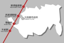
Railway
Highway
- Tōhoku Expressway – Nishinasuno-Shiobara IC
- Japan National Route 294
- Japan National Route 400
- Japan National Route 461
Local attractions
Ōtawara is home to several historical and cultural assets:
- Kasaishi Shrine (笠石神社) dating to the 690s AD has one of the oldest surviving example of writing in Japan
- Shino Kura Hall is a thatched roof style building dating to approximately the late 1850s or early 1860s, the end of the Edo period. The Hall displays old equipment and other artifacts dating to that time period such as large carts, a foot threshing machine, a packsaddle, and a milk machine. The Hall also serves handmade soba noodles using home-grown buckwheat.
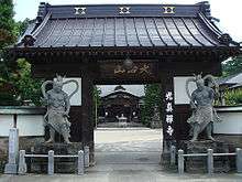
- Unganji (雲巌寺), a shrine in the east side of Ōtawara, and one at which Matsuo Bashō stopped during the journey that would later be recorded in The Narrow Road to the Deep North (Oku no Hosomichi). A stone engraved with a haiku he wrote inspired by what he saw there is displayed in the grounds of the shrine.
- site of Ōtawara Castle
- site of Kurobane Castle
- Ōtawara Onsen
- Kurobane Onsen
Sports and recreation
The largest sporting event the city hosts is the Tabara Hiroshi Marathon which is held annually on November 23, Labor Day. There are ten golf courses in the Ōtawara area. The golf courses include both public courses and private country clubs such the New St. Andrews Golf Club which is a Jack Nicklaus design course. Ōtawara has a large sports and recreation complex called the Tochigi Prefectural North Gymnasium. The gymnasium has a main arena for general sports and cultural events and includes two basketball and three volleyball courts, 10 badminton courts, 20 ping-pong tables, one handball court, 10 tennis courts, two wrestling and karate rings. The arena can seat up to 1,500 spectators. In addition, there is a separate smaller arena, martial arts area, and training rooms. Several other gymnasiums, community pools, and sports fields are located throughout the Ōtawara area.
External relations


Noted people
- Kazue Takahashi – voice actress
- Hokutōriki Hideki – sumo wrestler
- Masakazu Fukuda – professional wrestler[4]
- Yumiko Ōshima – cartoonist
References
External links
![]()
- Official Website (in Japanese)
- Ōtawara Tourism Association (in Japanese)
| Core city | ||
|---|---|---|
| Cities | ||
| Districts | ||