Nagarpur Upazila
| Nagarpur নাগরপুর | |
|---|---|
| Upazila | |
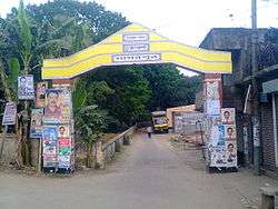 Nagarpur Upazila Gate | |
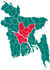
 Nagarpur Location in Bangladesh | |
| Coordinates: 24°3′N 89°52.5′E / 24.050°N 89.8750°ECoordinates: 24°3′N 89°52.5′E / 24.050°N 89.8750°E | |
| Country |
|
| Division | Dhaka Division |
| District | Tangail District |
| Established on | 9 September 1983 |
| Area | |
| • Total | 262.7 km2 (101.4 sq mi) |
| Population (2011) | |
| • Total | 288,092 |
| • Density | 1,097/km2 (2,840/sq mi) |
| Time zone | UTC+6 (BST) |
| Postal Code | 1936 |
| Website | |
Nagarpur (Bengali: নাগরপুর) is an Upazila of Tangail District in the Division of Dhaka, Bangladesh.
Geography
Nagarpur is located at 24°03′00″N 89°52′30″E / 24.0500°N 89.8750°E. The total area of the Upazila is 266.7 km².
Demographics
As of the 2011 Bangladesh census, Nagarpur has a population of 288092. There are households 66523 in total.[1] Nagarpur Town has an area of 4.68 km2. The town has a population of 13110; male 51.25%, female 48.75%; density of population is 2801 per km2.
Education
Nagarpur has an average literacy rate of 42.7% (Male-46.3%, Female-39.6%).[2]
Administration
The thana of Nagarpur was established in 1906. It was turned into Upazila on 9 September 1983. Nagarpur Upazila consists 12 Unions, 212 Mauzas/Mahallas, and 250 villages.
Unions
The Union Parishads are:
See also
References
- ↑ "Tangail Table C-01 : Area, Households, Population, Density by Residence and Community" (PDF). bbs.gov.bd. Archived from the original (PDF) on 2014-11-13. Retrieved 2016-03-01.
- ↑ "Tangail Table C-06 : Distribution of Population aged 7 years and above by Literacy, Sex, Residence and Community" (PDF). bbs.gov.bd. Archived from the original (PDF) on 2014-11-13. Retrieved 2016-02-25.
| Upazila/Thana: | ||
|---|---|---|
This article is issued from
Wikipedia.
The text is licensed under Creative Commons - Attribution - Sharealike.
Additional terms may apply for the media files.