Madhupur Upazila
| Madhupur মধুপুর | |
|---|---|
| Upazila | |
 Madhupur Location in Bangladesh | |
| Coordinates: 24°37′N 90°1.5′E / 24.617°N 90.0250°ECoordinates: 24°37′N 90°1.5′E / 24.617°N 90.0250°E | |
| Country |
|
| Division | Dhaka Division |
| District | Tangail District |
| Parliamentary Area | Tangail-1 |
| Area | |
| • Total | 366.92 km2 (141.67 sq mi) |
| Population (2011) | |
| • Total | 296,729 |
| • Density | 809/km2 (2,100/sq mi) |
| Time zone | UTC+6 (BST) |
| Website | Official website of Madhupur |
Madhupur (Bengali: মধুপুর) is an Upazila of Tangail District[1] in the Division of Dhaka, Bangladesh.
Geography
Madhupur is located at 24°37′00″N 90°01′30″E / 24.6167°N 90.0250°E . It has 74984 households and total area of 500.67 km². It has a large forest area named 'Madhupurer Gor". Madhupur is famous throughout the country for delicious pineapples. Madhupur is bounded by Jamalpur Sadar upazila on the north, Gopalpur and Ghatail upazilas on the south, Muktagachha and Fulbaria upazilas on the east. Sarishabari and Gopalpur upazilas on west. Main rivers are Jhinai, Bangshi, Banar and Atrai.
Demographics
As of the 2011 Bangladesh census, Madhupur has a population of 296,729. Males constitute 51.13% of the population, and females 48.87%. Madhupur has an average literacy rate of 41.2% (Male-42.7% & Female-39.7)[2]
Economy
Land use Total land cultivable 32900 hectares, fallow land 2000 hectares; land under irrigation 65%.
Value of land The market value of the land of the first grade is Tk 10000 per 0.01 hectare. Main crops are paddy, jute, wheat, cotton, potato, patal, ginger, betel leaf, kasava and vegetables. Extinct and nearly extinct crops Indigo, varieties of pulses and aman paddy. Main fruits are mango, jackfruit, litchi, papaya, pineapple and olive.
Fisheries, dairies, poultries Fishery 18, dairy 28, poultry 103, hatchery 1. Communication facilities Roads: pucca 150 km, semi pucca 19 km; waterways 32 nautical mile. Traditional transport Palanquin (extinct).
Manufactories Silk mill 1, rice and flour mill 53, ice factory 17, lathe & welding 63, saw mill 109, bakery 7 and bidi factory 1.
Cottage industries Weaving 27, goldsmith 103, blacksmith 26, bamboo work 320, potteries 43, wood work 42, tailoring 216; apiculture by private initiative. Hats, bazars Hats and bazars are 45, most noted of which are Madhupur, Dhanbari and Garo Hat; fairs 3 (Sholakudi Mela, Dhanbari Baishakhi Mela & Dhalpur Boishakhi Mela).
The main exports are pineapple,[3] silk, cotton, jackfruit and honey. NGO activities Operationally important NGOs are brac, asa, Proshika and caritas, World Tourist Mission, Family and Child Welfare Centre, World Vision Bangladesh.
Arts and culture
Public library 1, rural club 73, cinema hall 6, playground 29. Main occupations Agriculture 52.29%, agricultural labourer 22.8%, wage labourer 2.82%, commerce 8.42%, transport 2.11%, service 2.79%, others 8.77%.
Administration
Madhupur has 01 Municipality (Madhupur, Bangladesh) and 6 Unions, 242 Mauzas/Mahallas, and 343 villages. The 6 Unions are:
- Arankhola Union
- Ausnara Union
- Alokdia Union
- Sholakuri Union
- Golabari Union
- Mirzabari Union
- Phulbagchala Union
Health
Health centres Upazila health complex 1, family welfare centre 11, satellite clinic 6, charitable dispensary 1, missionary hospital 1, leprosy hospital 1.
Photo gallery
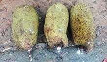
 Pineapple market, Jolsotro
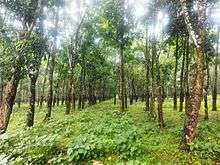
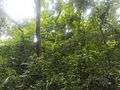 Modhupur National park
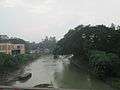 Bongshi River
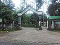 Main Gate of modhupur eco park
Education
College 5, High School 30, Madrasa 137, Government Primary School 156, Non-Government Primary School 53, Missionary High School 3, Missionary Primary School 13, Kindergarten 13, NGO Managed Primary School 57.
- Madhupur Shahid Smrity Higher Secondary School
- Alokdia High School
- Madhupur College
- Madhupur Rani Bhabani Model High School
- Madhupur Bahumukhi Model Technical Institute
See also
- Jalchatra Bazaar, Bangladesh
- Madhupur, Bangladesh
- Upazilas of Bangladesh
- Districts of Bangladesh
- Divisions of Bangladesh
References
- ↑ Abedin, Joinal (2012). "Madhupur Upazila". In Islam, Sirajul; Jamal, Ahmed A. Banglapedia: National Encyclopedia of Bangladesh (Second ed.). Asiatic Society of Bangladesh.
- ↑ "Community Report: Tangail" (PDF). Population & Housing Census 2011. Bangladesh Bureau of Statistics. Archived from the original (PDF) on 2016-12-02. Retrieved 2017-06-18.
- ↑ "Pineapple growers demand processing centre in Madhupur". The Independent. Dhaka. July 22, 2015. Retrieved January 16, 2016.
| Upazila/Thana: | ||
|---|---|---|