Mystic Falls
| Mystic Falls | |
|---|---|
 Mystic Falls | |
| Location | Yellowstone National Park, Teton County, Wyoming |
| Coordinates | 44°29′03″N 110°52′26″W / 44.48417°N 110.87389°WCoordinates: 44°29′03″N 110°52′26″W / 44.48417°N 110.87389°W[1] |
| Type | Cascade |
| Total height | 70 feet (21 m) |
| Watercourse | Little Firehole River |
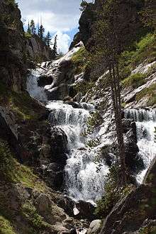
Mystic Falls is a 70-foot (21 m) cascade type waterfall on the Little Firehole River, a tributary of the Firehole River. Originally named Little Firehole Falls by members of the 1872 Hayden Geologic Survey, the name was changed to Mystic Falls by members of the Arnold Hague Geological Survey in 1885 for unknown reasons.[2]
Mystic Falls is reached via the 1.2 miles (1.9 km) Mystic Falls Trail which starts at Biscuit Basin in the Upper Geyser Basin.
Images of Mystic Falls
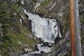
Spring runoff, June 2011
See also
Notes
- ↑ "Mystic Falls". Geographic Names Information System. United States Geological Survey.
- ↑ Whittlesey, Lee (1996). Yellowstone Place Names. Wonderland Publishing Company Gardiner, MT. p. 185. ISBN 1-59971-716-6.
Yellowstone National Park - Upper Geyser Basin | ||
|---|---|---|
Geothermal features and other attractions in the Upper Geyser Basin | ||
| Geysers |
|  |
| Hot Springs | ||
| Lone Star Geyser Basin | ||
| Structures and History | ||
| Geography | ||
| ||
This article is issued from
Wikipedia.
The text is licensed under Creative Commons - Attribution - Sharealike.
Additional terms may apply for the media files.