Muqlus
| Muqlus مقلس Mqlos | |
|---|---|
| Village | |
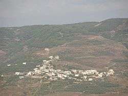 View of Muklous from a distance | |
| Nickname(s): Mqlos, Muklous or Mukloss | |
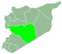
 Muqlus Location in Syria | |
| Coordinates: 34°49′49″N 36°20′52″E / 34.83028°N 36.34778°E | |
| Country |
|
| Governorate | Homs |
| District | Talkalakh |
| Subdistrict | Hawash |
| Settled | 1st century CE |
| Elevation | 800 m (2,600 ft) |
| Population (2004) | |
| • Total | 375 |
| Time zone | UTC+3 (EET) |
| • Summer (DST) | UTC+2 (EEST) |
Muqlus or Mqlos (Arabic: مقلس, also spelled Mqlos, Mukloss, Muklous or Muklis) is a village in central Syria, administratively part of the Homs Governorate, located about 40 kilometers west of Homs. It is situated in the Wadi al-Nasara ("Valley of Christians") north of Lebanon. Nearby localities include Hasour to the north, al-Nasirah to the southwest, Mazinah to the south, Shin to the southeast, Rabah to the east and Fahel to the northeast. According to the Syria Central Bureau of Statistics (CBS), Muklous had a population of 375 in the 2004 census.[1]
Etymology
The name Muklous is translated as "eye of the lion".
Demographics
Muklous had a population of 375 in 2004.[2] Its inhabitants are predominantly Greek Orthodox Christians and Alawites.[3] Expatriates from the village have settled in the Americas and Europe as well as the Persian Gulf region and Lebanon.
Economy
Muklous' industry is mainly agriculture, including apples, olives, figs, grapes, plums, peaches and pomegranates. The village also hosts a factory producing "select vinegar" from the ground fall apples that cannot be otherwise used.
References
- ↑ General Census of Population and Housing 2004. Syria Central Bureau of Statistics (CBS). Homs Governorate. (in Arabic)
- ↑ General Population and Housing Census. Central Bureau of Statistics (Syria). 2004.
- ↑ Smith, 1841, p. 182.
Bibliography
- Smith, Eli; Robinson, Edward (1841). Biblical Researches in Palestine, Mount Sinai and Arabia Petraea: A Journal of Travels in the Year 1838. 3. Crocker and Brewster.
|  | |||||||||||||||||||||||||||||
|
| ||||||||||||||||||||||||||||||
| ||||||||||||||||||||||||||||||
| ||||||||||||||||||||||||||||||
| ||||||||||||||||||||||||||||||