Bureij, Syria
| Bureij البريج al-Burayj | |
|---|---|
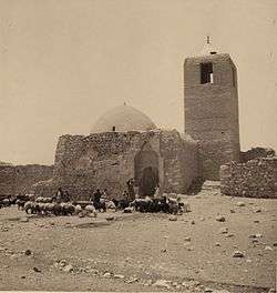 Bureij in 1936 | |
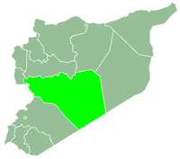
 Bureij Location in Syria | |
| Coordinates: 34°15′30″N 36°46′16″E / 34.25833°N 36.77111°E | |
| Country |
|
| Governorate | Homs |
| District | Homs |
| Subdistrict | Hisyah |
| Population (2004) | |
| • Total | 2,246 |
Bureij (Arabic: البريج, also spelled Burayj) is a village in central Syria, administratively part of the Homs Governorate, south of Homs. Nearby localities include Hisyah to the north, Sadad to the northeast and Qarah to the south. According to the Central Bureau of Statistics (CBS), Bureij had a population of 2,246 in the 2004 census.[1] Its inhabitants are predominantly Sunni Muslims.[2]
In the 19th-century, during Ottoman Empire rule, Bureij was a small fortified village with a khan ("caravansary"). While its residents were relatively protected from Bedouin raids because of the village's high walls, their livestock was often plundered.[3] The name "Bureij" is the Arabic term for "little tower."[4]
References
- ↑ General Census of Population and Housing 2004. Syria Central Bureau of Statistics (CBS). Homs Governorate. (in Arabic)
- ↑ Smith, 1841, p. 173.
- ↑ Porter, 1858 p. 550.
- ↑ Baedeker, 1876, p. 556.
Bibliography
- Baedeker, Karl (1876). Palestine and Syria, Handbook for Travellers. 1. Karl Baedeker.
- Porter, Josias Leslie (1858). A Handbook for Travellers in Syria and Palestine. 1. Murray.
- Smith, Eli; Robinson, Edward (1841). Biblical Researches in Palestine, Mount Sinai and Arabia Petraea: A Journal of Travels in the Year 1838. 3. Crocker and Brewster.
|  | |||||||||||||||||||||||||||||
|
| ||||||||||||||||||||||||||||||
| ||||||||||||||||||||||||||||||
| ||||||||||||||||||||||||||||||
| ||||||||||||||||||||||||||||||
This article is issued from
Wikipedia.
The text is licensed under Creative Commons - Attribution - Sharealike.
Additional terms may apply for the media files.