Municipality of Hrpelje-Kozina
| Municipality of Hrpelje-Kozina Občina Hrpelje - Kozina | |
|---|---|
| Municipality | |
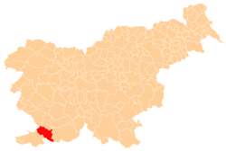 Location of the Municipality of Hrpelje-Kozina in Slovenia | |
| Coordinates: 45°35′N 13°59′E / 45.583°N 13.983°ECoordinates: 45°35′N 13°59′E / 45.583°N 13.983°E | |
| Country |
|
| Government | |
| • Mayor | Saša Likavec Svetelšek |
| Area | |
| • Total | 192.2 km2 (74.2 sq mi) |
| Population (2002)[1] | |
| • Total | 4,038 |
| • Density | 21/km2 (54/sq mi) |
| Time zone | UTC+01 (CET) |
| • Summer (DST) | UTC+02 (CEST) |
The Municipality of Hrpelje-Kozina (pronounced [xəɾˈpeːljɛ kɔˈziːna]; Slovene: Občina Hrpelje - Kozina) is a municipality in the Littoral region of Slovenia. Its main settlements are Hrpelje and Kozina.[2]
A major border crossing to Italy is located in the municipality at the village of Krvavi Potok. It connects to Pese di Grozzana in the Municipality of San Dorligo della Valle near Trieste on the Italian side.
References
External links

- Municipality of Hrpelje-Kozina on Geopedia
| Settlements | Administrative centre: Hrpelje
| |
|---|---|---|
| Landmarks |
| |
This article is issued from
Wikipedia.
The text is licensed under Creative Commons - Attribution - Sharealike.
Additional terms may apply for the media files.