Municipality of Jesenice
| Municipality of Jesenice Občina Jesenice | |
|---|---|
| Municipality | |
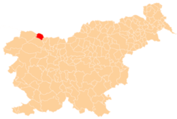 Location of the Municipality of Jesenice in Slovenia | |
| Coordinates: 46°26′N 14°03′E / 46.433°N 14.050°ECoordinates: 46°26′N 14°03′E / 46.433°N 14.050°E | |
| Country |
|
| Government | |
| • Mayor | Tomaž Tom Mencinger (SD) |
| Area | |
| • Total | 75.8 km2 (29.3 sq mi) |
| Elevation | 576.3 m (1,890.7 ft) |
| Population (2002)[1] | |
| • Total | 21,688 |
| • Density | 290/km2 (740/sq mi) |
| Time zone | UTC+01 (CET) |
| • Summer (DST) | UTC+02 (CEST) |
The Municipality of Jesenice (pronounced [jɛsɛˈniːtsɛ] (![]()
References
External links
| Wikimedia Commons has media related to Municipality of Jesenice. |
| Settlements | Administrative centre: Jesenice
| | ||||
|---|---|---|---|---|---|---|
| Landmarks | ||||||
| Places of worship | ||||||
| Notable people |
| |||||
This article is issued from
Wikipedia.
The text is licensed under Creative Commons - Attribution - Sharealike.
Additional terms may apply for the media files.