Zavrč
| Zavrč Občina Zavrč | |
|---|---|
| Town and Municipality | |
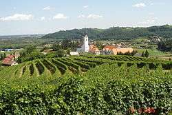 Zavrč as seen from the church of St Mary | |
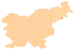 Location of the Municipality of Zavrč in Slovenia | |
 Zavrč Location of the Town of Zavrč in Slovenia | |
| Coordinates: 46°23′N 16°03′E / 46.383°N 16.050°ECoordinates: 46°23′N 16°03′E / 46.383°N 16.050°E | |
| Country |
|
| Government | |
| • Mayor | Miran Vuk |
| Area | |
| • Total | 19.3 km2 (7.5 sq mi) |
| Population (2016) | |
| • Total | 1,722 |
| • Density | 89/km2 (230/sq mi) |
| Time zone | UTC+01 (CET) |
| • Summer (DST) | UTC+02 (CEST) |
Zavrč (pronounced [ˈzaːʋəɾtʃ]) is a settlement and a municipality in the Haloze area of Slovenia. It lies between the right bank of the Drava River and the border with Croatia. The area traditionally belonged to the region of Styria. It is now included in the Drava Statistical Region.[1]
History
The Roman road that connected Poetovio and Mursa Maior led through the area. The parish church in Zavrč is dedicated to Saint Nicholas and belongs to the Roman Catholic Archdiocese of Maribor. It was first mentioned in written documents dating to 1430 as Saurig or Sauritsch. It was modified in the 17th and 18th centuries.[2] The first school was established in 1671, when pupils were taught in a private house. Church records show that in 1812 the priest gave permission to reconstruct the classroom, so more pupils were able to attend. The school building was built in 1889. There is a second church on a small hill northwest of the settlement. It is dedicated to the Virgin Mary.[3] Zavrč Mansion is a mansion close to the parish church. It was built in the 17th century and expanded in 1718. It now houses the municipal authorities.[4]
Sports
The local football club is called NK Zavrč. They managed to get promoted all the way from the Slovenian Sixth Division to the Slovenian First Division in just five years.[5]
References
- ↑ Zavrč municipal site
- ↑ Slovenian Ministry of Culture register of national heritage Archived 12 July 2010 at the Wayback Machine. reference number 3523
- ↑ Slovenian Ministry of Culture register of national heritage Archived 12 July 2010 at the Wayback Machine. reference number 3524
- ↑ Slovenian Ministry of Culture register of national heritage Archived 12 July 2010 at the Wayback Machine. reference number 6518
- ↑ NK Zavrč official website
External links
- Zavrč municipal website (in Slovene)
- Municipality of Zavrč on Geopedia
| Settlements | Administrative centre: Zavrč
| |
|---|---|---|
| Landmarks |
| |