Škofljica
| Škofljica Občina Škofljica | |
|---|---|
| Town and Municipality | |
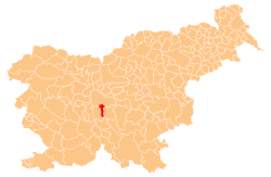 Location of the Municipality of Škofljica in Slovenia | |
 Škofljica Location of the Town of Škofljica in Slovenia | |
| Coordinates: 45°59′N 14°35′E / 45.983°N 14.583°ECoordinates: 45°59′N 14°35′E / 45.983°N 14.583°E | |
| Country |
|
| Government | |
| • Mayor | Ivan Jordan |
| Area | |
| • Total | 43.3 km2 (16.7 sq mi) |
| Elevation | 305.2 m (1,001.3 ft) |
| Population (2009)[1] | |
| • Total | 9,124 |
| • Density | 210/km2 (550/sq mi) |
| Time zone | UTC+01 (CET) |
| • Summer (DST) | UTC+02 (CEST) |
Škofljica (pronounced [ˈʃkoːfljitsa]; German: Geweihtenbrunn[2]) is a settlement and a municipality in central Slovenia. It lies on the eastern edge of the marshlands south of the capital Ljubljana. The entire municipality is part of the traditional region of Lower Carniola and is now included in the Central Slovenia Statistical Region.
The parish church in the settlement is dedicated to Saints Cyril and Methodius and belongs to the Roman Catholic Archdiocese of Ljubljana. It is a modern building built in 1986.[3]
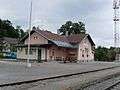 Train station in Škofljica
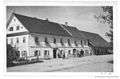 Postcard of Škofljica
.jpg) Postcard of Škofljica
Postcard of Škofljica
Settlements in Škofljica
Dole pri Škofljici, Drenik, Glinek, Gorenje Blato, Gradišče, Gumnišče, Klada, Lanišče, Lavrica, Orle, Pijava Gorica, Pleše, Reber pri Škofljici, Smrjene, Škofljica, Vrh nad Želimljami, Zalog pri Škofljici, Želimlje
References
- ↑ Škofljica municipal site
- ↑ Leksikon občin kraljestev in dežel zastopanih v državnem zboru, vol. 6: Kranjsko. 1906. Vienna: C. Kr. Dvorna in Državna Tiskarna, p. 113.
- ↑ Slovenian Ministry of Culture register of national heritage reference number ešd 4157
External links
| Settlements | Administrative centre: Škofljica
| | ||||
|---|---|---|---|---|---|---|
| Landmarks |
| |||||
This article is issued from
Wikipedia.
The text is licensed under Creative Commons - Attribution - Sharealike.
Additional terms may apply for the media files.