Municipality of Rače-Fram
| Municipality of Rače–Fram Občina Rače - Fram | |
|---|---|
| Municipality | |
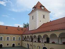 Rače Castle | |
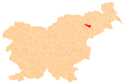 Location of the Municipality of Rače–Fram in Slovenia | |
| Coordinates: 46°27′22″N 15°37′45″E / 46.45611°N 15.62917°ECoordinates: 46°27′22″N 15°37′45″E / 46.45611°N 15.62917°E | |
| Country |
|
| Government | |
| • Mayor | Branko Ledinek |
| Area | |
| • Total | 51.2 km2 (19.8 sq mi) |
| Population (2002)[1] | |
| • Total | 6,000 |
| • Density | 120/km2 (300/sq mi) |
| Time zone | UTC+01 (CET) |
| • Summer (DST) | UTC+02 (CEST) |
The Municipality of Rače–Fram (pronounced [ˈɾaːtʃɛ ˈfɾaːm]; Slovene: Občina Rače - Fram) is a municipality south of Maribor in northeastern Slovenia. Its administrative centre is the settlement of Rače. The area was traditionally was part of the Styria region. It is now included in the Drava Statistical Region. The municipality covers an area of 52 square kilometres (20 sq mi) and extends from the plain on the right bank of the Drava River into the Pohorje Hills. The Ljubljana–Maribor motorway and railway line run through the municipality.[2]
References
External links
| Settlements | Administrative centre: Rače
| | ||||
|---|---|---|---|---|---|---|
| Landmarks |
| |||||
This article is issued from
Wikipedia.
The text is licensed under Creative Commons - Attribution - Sharealike.
Additional terms may apply for the media files.