Kozina
| Kozina | |
|---|---|
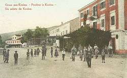 1908 postcard of Kozina | |
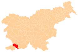
 Kozina Location in Slovenia | |
| Coordinates: 45°36′32.8″N 13°56′11.57″E / 45.609111°N 13.9365472°ECoordinates: 45°36′32.8″N 13°56′11.57″E / 45.609111°N 13.9365472°E | |
| Country |
|
| Traditional region | Littoral |
| Statistical region | Coastal–Karst |
| Municipality | Hrpelje-Kozina |
| Area | |
| • Total | 2.96 km2 (1.14 sq mi) |
| Elevation | 492.7 m (1,616.5 ft) |
| Population (2002) | |
| • Total | 572 |
| [1] | |
Kozina (pronounced [kɔˈziːna] (![]()
The village developed only after the railway was established; in 1825 there were only three houses in Kozina. It became an important center for teamsters, with twelve inns with stalls for teamsters' horses.[3] Today it lies at the intersection of the Ljubljana–Koper freeway with the Trieste–Rijeka route.
References
- ↑ Statistical Office of the Republic of Slovenia. stat.si
- ↑ Hrpelje-Kozina municipal site Archived 2008-12-18 at the Wayback Machine.. hrpelje-kozina.si
- ↑ Savnik, Roman (ed.). 1968. Krajevni leksikon Slovenije, vol 1. Ljubljana: Državna založba Slovenije, p. 318.
External links
| Wikimedia Commons has media related to Kozina. |
| Settlements | Administrative centre: Hrpelje
|  |
|---|---|---|
| Landmarks |
| |
This article is issued from
Wikipedia.
The text is licensed under Creative Commons - Attribution - Sharealike.
Additional terms may apply for the media files.