Shire of Mount Rouse
| Shire of Mount Rouse Victoria | |||||||||||||||
|---|---|---|---|---|---|---|---|---|---|---|---|---|---|---|---|
 Location in Victoria | |||||||||||||||
| Population | 2,350 (1992)[1] | ||||||||||||||
| • Density | 1.670/km2 (4.326/sq mi) | ||||||||||||||
| Established | 1860 | ||||||||||||||
| Area | 1,407 km2 (543.2 sq mi) | ||||||||||||||
| Council seat | Penshurst | ||||||||||||||
| County | Villiers | ||||||||||||||
| |||||||||||||||
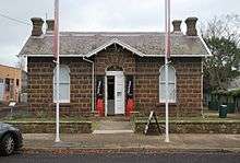
Former council chambers, Penshurst
The Shire of Mount Rouse was a local government area about 270 kilometres (168 mi) west of Melbourne, the state capital of Victoria, Australia. The shire covered an area of 1,407 square kilometres (543.2 sq mi), and existed from 1860 until 1994.
History
Mount Rouse was incorporated as a road district on 2 October 1860 and became a shire on 26 January 1864.[2]
On 23 September 1994, the Shire was abolished, and merged with City of Hamilton, Shire of Wannon and most of Dundas into the Shire of Southern Grampians.[3]
Wards
Mount Rouse was divided into three ridings, each of which elected three councillors:
- Dunkeld Riding
- Glenthompson Riding
- Penshurst Riding
Towns and localities
- Chatsworth
- Dunkeld
- Glenthompson
- Penshurst
- Tabor
Population
| Year | Population |
|---|---|
| 1954 | 2,859 |
| 1958 | 3,010* |
| 1961 | 3,056 |
| 1966 | 3,044 |
| 1971 | 2,693 |
| 1976 | 2,569 |
| 1981 | 2,474 |
| 1986 | 2,263 |
| 1991 | 2,250 |
* Estimate in the 1958 Victorian Year Book.
References
- ↑ Australian Bureau of Statistics, Victoria Office (1994). Victorian Year Book. pp. 49–52. ISSN 0067-1223.
- ↑ Victorian Municipal Directory. Brunswick: Arnall & Jackson. 1992. pp. 774–775. Accessed at State Library of Victoria, La Trobe Reading Room.
- ↑ Australian Bureau of Statistics (1 August 1995). Victorian local government amalgamations 1994-1995: Changes to the Australian Standard Geographical Classification (PDF). Commonwealth of Australia. p. 10,11. ISBN 0-642-23117-6. Retrieved 2008-01-05.
This article is issued from
Wikipedia.
The text is licensed under Creative Commons - Attribution - Sharealike.
Additional terms may apply for the media files.