City of Geelong West
| City of Geelong West Victoria | |||||||||||||||
|---|---|---|---|---|---|---|---|---|---|---|---|---|---|---|---|
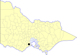 Location in Victoria | |||||||||||||||
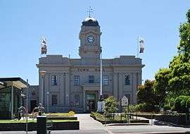 Geelong West Town Hall | |||||||||||||||
| Population | 13,630 (1992)[1] | ||||||||||||||
| • Density | 2,591/km2 (6,711/sq mi) | ||||||||||||||
| Established | 1875 | ||||||||||||||
| Area | 5.26 km2 (2.0 sq mi) | ||||||||||||||
| Council seat | Geelong West | ||||||||||||||
| County | Grant | ||||||||||||||
 | |||||||||||||||
The City of Geelong West was a local government area about 5 kilometres (3 mi) west of the regional city of Geelong, Victoria, Australia. The city covered an area of 5.26 square kilometres (2.0 sq mi), and existed from 1875 until 1993.
History
Geelong West was first incorporated as a borough on 29 May 1875, and became a town on 22 March 1922. After annexing the Moorpanyal Riding of the Shire of Corio on 9 December 1926, to form its fourth ward (West Ward), it was proclaimed as a city on 17 April 1929.[2]
On 18 May 1993, the City of Geelong West was abolished, and, along with the Cities of Geelong and Newtown, the Rural City of Bellarine, the Shire of Corio and parts of the City of South Barwon and the Shires of Barrabool and Bannockburn, was merged into the newly created City of Greater Geelong.[3]
Wards
The City of Geelong West was divided into four wards, each of which elected three councillors:
- Little Scotland Ward
- Ashby Ward
- Kildare Ward
- Manifold Ward
Geography
The City was bounded by La Trobe Terrace to the east, Aberdeen, Minerva and Autumn Streets to the south, McCurdy Road to the west and Church Street, Western Oval and Coxon and Bell Parades to the north.[2] It included the suburbs of Geelong West, Drumcondra, Herne Hill and Manifold Heights.
The Town Hall was located at Pakington and Albert Streets, Geelong West.
Population
| Year | Population |
|---|---|
| 1954 | 17,313 |
| 1958 | 18,290* |
| 1961 | 17,681 |
| 1966 | 17,446 |
| 1971 | 17,248 |
| 1976 | 15,978 |
| 1981 | 14,823 |
| 1986 | 13,802 |
| 1991 | 13,448 |
* Estimate in the 1958 Victorian Year Book.
References
- ↑ Australian Bureau of Statistics, Victoria Office (1994). Victorian Year Book. pp. 49–52. ISSN 0067-1223.
- 1 2 Victorian Municipal Directory. Brunswick: Arnall & Jackson. 1992. pp. 385–386. Accessed at State Library of Victoria, La Trobe Reading Room.
- ↑ Public Record Office (Victoria) (2005). "Agency VA 2431 - Geelong". Retrieved 2008-04-21.