Morogoro Region
| Morogoro Region Mkoa wa Morogoro (Swahili) | |
|---|---|
| Region | |
 | |
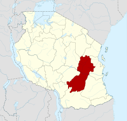 Location in Tanzania | |
| Country | Tanzania |
| Zone | Coastal |
| Capital | Morogoro |
| Government | |
| • Regional Commissioner | Joel Bendera |
| Area | |
| • Total | 70,624 km2 (27,268 sq mi) |
| Population (2012) | |
| • Total | 2,218,492 |
| • Density | 31/km2 (81/sq mi) |
| Time zone | UTC+3 (EAT) |
| Postcode | 67xxx |
| Area code(s) | 023 |
| Website | Regional website |
Morogoro Region is one of Tanzania's 31 administrative regions. The regional capital is the municipality of Morogoro. According to the 2012 national census, the region had a population of 2,218,492, which was higher than the pre-census projection of 2,209,072 .[1]:page 2 For 2002-2012, the region's 2.4 percent average annual population growth rate was tied for the fourteenth highest in the country.[1]:page 4 It was also the 22nd most densely populated region with 31 people per square kilometer.[1]:page 6
Morogoro Region is bordered to the north by the Tanga Region, to the east by the Pwani and Lindi Regions, to the south by the Ruvuma Region and to the west by the Iringa and Dodoma Regions.
The regional commissioner of the Morogoro Region is Dr.Kebwe Steven Kebwe.[2]
Administrative subdivisions
Districts
The region is administratively divided into seven districts:
| Districts of Morogoro Region | ||||||
|---|---|---|---|---|---|---|
| Map | District | Population (2012) | ||||
 |
Gairo | 193,011 | ||||
| Kilombero | 407,880 | |||||
| Kilosa | 438,175 | |||||
| Morogoro | 602,114 | |||||
| Mvomero | 312,109 | |||||
| Ulanga | 265,203 | |||||
| Total | style="text-align:right;" 2,218,492 | |||||
Constituencies
For parliamentary elections, Tanzania is divided into constituencies. As of the 2010 elections Morogoro Region had ten constituencies:[3]
|
|
Education
The Morogoro Region has a number of universities, including the Sokoine University of Agriculture, Jordan University College, Morogoro Muslim University, and Mzumbe University. There are also colleges such as Morogoro Teachers' College, Dakawa Teachers' College, and Land College.
Recreations
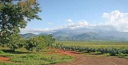
Morogoro region also hosts the lots of wild animals some of which are in The Big Five scattered in Mikumi National Park , Udzungwa Mountains National Park and Selous Game reserve.
References
- 1 2 3 Population Distribution by Administrative Units, United Republic of Tanzania, 2013 Archived 2013-05-02 at the Wayback Machine.
- ↑ Kitabu cha Mawasiliano Serikalini, Tanzania Government Directory, 2012, page 175
- ↑ "Organisations located in Morogoro Region - Tanzania". African Development Information.
| Mainland | ||
|---|---|---|
| Zanzibar | ||
Coordinates: 8°00′S 37°00′E / 8.000°S 37.000°E