Morgan's Point, Texas
| Morgan's Point, Texas | |
|---|---|
| City | |
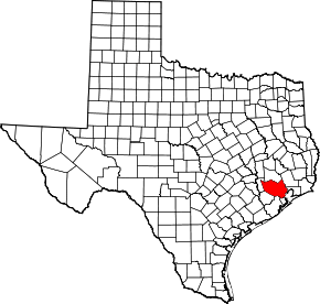
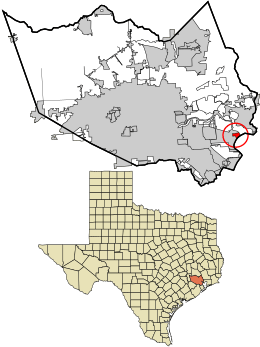 Location in Harris County and the state of Texas | |
| Coordinates: 29°40′35″N 94°59′58″W / 29.67639°N 94.99944°WCoordinates: 29°40′35″N 94°59′58″W / 29.67639°N 94.99944°W | |
| Country | United States |
| State | Texas |
| County | Harris |
| Area | |
| • Total | 1.7 sq mi (4.5 km2) |
| • Land | 1.5 sq mi (4.0 km2) |
| • Water | 0.2 sq mi (0.5 km2) |
| Elevation | 20 ft (6 m) |
| Population (2018) | |
| • Total | 1,476 |
| • Density | 222/sq mi (85.6/km2) |
| Time zone | UTC-6 (Central (CST)) |
| • Summer (DST) | UTC-5 (CDT) |
| ZIP code | 76513 |
| Area code(s) | 713/281/346/832 |
| FIPS code | 48-49380[1] |
| GNIS feature ID | 1388192[2] |
| Website |
morganspoint-tx |
Morgan's Point is a city in Harris County, Texas, United States, located on the shores of Galveston Bay at the inlet to the Houston Ship Channel, near La Porte and Pasadena. As of the 2010 census, it had a population of 339.[3] It earned fame in Texas' early history for being the home of the legendary Emily West (Morgan), known as "The Yellow Rose of Texas". It later became a Houston-area resort community for the wealthy in the early 20th century. Today, thanks to the construction of the Barbours Cut shipping terminal, it is at the center of one the area's most important shipping hubs.
History
The area was first settled in 1822 by Nicholas Rightor, a surveyor commissioned by Stephen F. Austin to explore and survey the areas between the Brazos and Lavaca rivers.[4] He soon sold the property to Johnson Calhoun Hunter, and it subsequently was bought by Joseph C. Clopper, who used the property to grow orange and lemon trees. The property was finally sold to James Morgan in 1834, who established the short-lived colony of New Washington. Morgan had helped supply the Texian army during the Texas Revolution and was given the rank of colonel. The settlement was destroyed by the Mexican army during the Texas Revolution. A legend surfaced much later surrounding a mulatto woman named Emily West.[5] She became an indentured servant (but not a slave) of Morgan and, according to legend, used her beauty to occupy Mexican General Santa Anna, thereby facilitating his capture by the Texan army, thus ending the revolutionary war. Historians differ on the degree of truth of this legend.
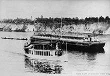
The area began to redevelop as the Houston Ship Channel was dredged near the area in the later 19th century. The community grew around traffic crossing the ship channel to and from Goose Creek (now Baytown). Ferry service would eventually become established. The Morgan Point Ferry operated until the mid 20th century.
Following the start of the Texas oil boom in 1901 Galveston Bay became an attractive summer destination for the wealthy from Houston and nearby areas.[6] Plots along Bayridge Road were sold for the construction of summer homes, including the famed Sterling Mansion, a former governor's residence that is now a landmark (not to be confused with the mansion in Houston).[7] During the 1920s and '30s the shoreline between Morgan's Point and Sylvan Beach came to be known as the Texas "Gold Coast", a playground for the rich.[8]
As the surrounding communities of La Porte and Pasadena grew, interest in the area as a summer haven diminished. Morgan's Point was finally incorporated in 1949, and a small community remained. Some of the original 19th century buildings have remained, as well as early 20th century homes.[4]
The area received a major economic boost in 1977 with the opening of the Barbours Cut shipping terminal, operated by the Port of Houston Authority. However, in building Barbours Cut, the Port of Houston used its power of eminent domain to evict residents from nearly one third of the community's homes.[9] Still the terminal almost instantly became the Houston area's most important shipping point and became the centerpiece of the economy activity at Morgan's Point.[10]
Geography
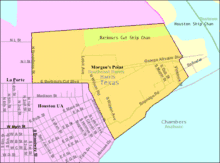
Morgan's Point is located in southeastern Harris County at 29°40′35″N 94°59′58″W / 29.67639°N 94.99944°W (29.676368, -94.999580).[11] It is bordered to the north and west by the city of La Porte, and to the southeast by Galveston Bay. The city limits extend out into Galveston Bay, within Chambers County. It is 27 miles (43 km) east of the center of Houston.
According to the United States Census Bureau, the city has a total area of 1.7 square miles (4.5 km2), of which 1.5 square miles (4.0 km2) are land and 0.2 square miles (0.5 km2), or 11.12%, are water.[3]
Demographics
| Historical population | |||
|---|---|---|---|
| Census | Pop. | %± | |
| 1950 | 656 | — | |
| 1960 | 560 | −14.6% | |
| 1970 | 593 | 5.9% | |
| 1980 | 428 | −27.8% | |
| 1990 | 341 | −20.3% | |
| 2000 | 336 | −1.5% | |
| 2010 | 339 | 0.9% | |
| Est. 2016 | 351 | [12] | 3.5% |
| U.S. Decennial Census[13] | |||
As of the census[1] of 2000, there were 336 people, 111 households, and 85 families residing in the city. The population density was 208.1 people per square mile (80.6/km²). There were 143 housing units at an average density of 88.6 per square mile (34.3/km²). The racial makeup of the city was 88.69% White, 4.46% African American, 0.89% Native American, 4.46% from other races, and 1.49% from two or more races. Hispanic or Latino of any race were 12.80% of the population.
There were 111 households out of which 19.8% had children under the age of 18 living with them, 64.9% were married couples living together, 9.0% had a female householder with no husband present, and 23.4% were non-families. 23.4% of all households were made up of individuals and 9.9% had someone living alone who was 65 years of age or older. The average household size was 2.32 and the average family size was 2.64.
In the city, the population was spread out with 32.4% under the age of 18, 5.7% from 18 to 24, 19.9% from 25 to 44, 28.0% from 45 to 64, and 14.0% who were 65 years of age or older. The median age was 38 years. For every 100 females, there were 114.0 males. For every 100 females age 18 and over, there were 102.7 males.
The median income for a household in the city was $57,917, and the median income for a family was $71,458. Males had a median income of $40,313 versus $30,625 for females. The per capita income for the city was $32,446. None of the families and 2.2% of the population were living below the poverty line, including no under eighteens and none of those over 64.
Education
Morgan's Point is within the La Porte Independent School District and is zoned to La Porte High School.
See also
References
- 1 2 "American FactFinder". United States Census Bureau. Retrieved 2008-01-31.
- ↑ "US Board on Geographic Names". United States Geological Survey. 2007-10-25. Retrieved 2008-01-31.
- 1 2 "Geographic Identifiers: 2010 Census Summary File 1 (G001): Morgan's Point city, Texas". American Factfinder. U.S. Census Bureau. Retrieved February 5, 2018.
- 1 2 Morgan's Point, Texas from the Handbook of Texas Online
- ↑ Morgan's Point, Texas from the Handbook of Texas Online
- ↑ McQueary, Carl (2003). Dining at the Governor's Mansion. Texas A&M University Press.
- ↑ Fox, Stephen; Cheek, Richard (2007). The country houses of John F. Staub. Texas A&M University Press. p. 212.
- ↑ Kearney, Syd (2008). A Marmac Guide to Houston and Galveston. Pelican Publishing. pp. 177–178.
- ↑ "Environmental Report Cards for 10 U.S. Ports" (PDF). Harboring Pollution: The Dirty Truth about U.S. Ports. Natural Resources Defense Council: 50. March 2004.
- ↑ Cartwright, Gary (July 1978). "On the Waterfront". Texas Monthly: 161–162.
- ↑ "US Gazetteer files: 2010, 2000, and 1990". United States Census Bureau. 2011-02-12. Retrieved 2011-04-23.
- ↑ "Population and Housing Unit Estimates". Retrieved June 9, 2017.
- ↑ "Census of Population and Housing". Census.gov. Retrieved June 4, 2015.
External links
- City of Morgan's Point official website
- Morgan's Point from the Handbook of Texas Online
- The University of Houston Digital Library has a collection of historical photographs about Houston, nearby communities, and more. View these collections at the University of Houston Digital Libraries
| Large cities |  | |
|---|---|---|
| Other cities | ||
| CDPs and non- municipalities | ||
| Counties | ||
| Subregions | ||
| Bodies of water | ||
| Major ports | ||
| Nature preserves | ||
| Counties | 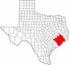 | |
|---|---|---|
| "Principal" cities | ||
| Other cities |
For a complete listing, see list of cities and towns in Houston–The Woodlands–Sugar Land MSA | |
| Unincorporated areas | ||
| Bodies of water | ||
