Jordan Airport
| Jordan Airport | |||||||||||
|---|---|---|---|---|---|---|---|---|---|---|---|
| Summary | |||||||||||
| Airport type | Public | ||||||||||
| Owner | Garfield County | ||||||||||
| Serves | Jordan, Montana | ||||||||||
| Elevation AMSL | 2,662 ft / 811 m | ||||||||||
| Coordinates | 47°19′44″N 106°57′10″W / 47.32889°N 106.95278°W | ||||||||||
| Runways | |||||||||||
| |||||||||||
| Statistics (2008) | |||||||||||
| |||||||||||
Jordan Airport (IATA: JDN, ICAO: KJDN, FAA LID: JDN) is a county-owned, public-use airport located two nautical miles (4 km) northwest of the central business district of Jordan, a town in Garfield County, Montana, United States.[1] It is included in the National Plan of Integrated Airport Systems for 2011–2015, which categorized it as a general aviation airport.[2]
Facilities and aircraft
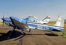
Agricultural and business aircraft at Jordan Airport.
Jordan Airport covers an area of 234 acres (95 ha) at an elevation of 2,662 feet (811 m) above mean sea level. It has one runway designated 11/29 with an asphalt surface measuring 4,300 by 75 feet (1,311 x 23 m). For the 12-month period ending August 6, 2008, the airport had 2,050 general aviation aircraft operations, an average of 170 per month.[1]
References
- 1 2 3 FAA Airport Master Record for JDN (Form 5010 PDF). Federal Aviation Administration. Effective April 5, 2012.
- ↑
"2011–2015 NPIAS Report, Appendix A (PDF, 2.03 MB)" (PDF). National Plan of Integrated Airport Systems. Federal Aviation Administration. October 4, 2010. Archived from the original (PDF) on September 27, 2012. External link in
|work=(help)
External links
- Resources for this airport:
- FAA airport information for JDN
- AirNav airport information for KJDN
- ASN accident history for JDN
- FlightAware airport information and live flight tracker
- NOAA/NWS latest weather observations
- SkyVector aeronautical chart, Terminal Procedures
This article is issued from
Wikipedia.
The text is licensed under Creative Commons - Attribution - Sharealike.
Additional terms may apply for the media files.