Menard-Hodges Site
 | |
 Menard-Hodges Mounds Location within Arkansas today | |
| Alternative name | Osotouy |
|---|---|
| Location |
Watson, Arkansas, |
| Region | Arkansas County, Arkansas |
| Coordinates | 34°0′13.93″N 91°15′15.17″W / 34.0038694°N 91.2542139°WCoordinates: 34°0′13.93″N 91°15′15.17″W / 34.0038694°N 91.2542139°W |
| History | |
| Cultures | Mississippian culture, Quapaw |
| Site notes | |
| Archaeologists | James A. Ford |
| Architecture | |
| Architectural styles | platform mounds |
| Architectural details | Number of monuments: 2 |
|
Menard-Hodges Site | |
| NRHP reference # | 85003542 |
| Significant dates | |
| Added to NRHP | October 31, 1985[1] |
| Designated NHL | April 11, 1989[2] |
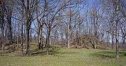
The Menard-Hodges Site (3AR4) (also known as Menard-Hodges Mounds and Osotouy), is an archaeological site in Arkansas County, Arkansas. It includes two large platform mounds as well as several house mounds. It is the type site for the Menard phase, a protohistoric Mississippian culture group.
The Menard Mound was named for Frank Menard, on whose farm the mound was discovered.[3]
Description
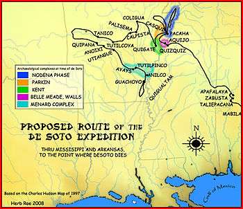
The site is considered as a possible candidate for the Province of Anilco encountered by the Hernando de Soto Entrada in 1540.[4] It was contemporaneous with the Parkin site, believed by many archaeologists to be the location of the province of Casqui,[5][6] and the Nodena Site, believed by many archaeologists to be the location of the province of Pacaha.[5][6]
The site is also considered to be the location of the protohistoric Quapaw village of Osotouy (or Ossoteoue) first encountered by French explorers in the late 17th century.[7][8] The Quapaw at the time had four villages, Kappa, Ossoteoue, Touriman, and Tonginga. Kappa was reported to have been on the eastern bank of the Mississippi River and the other three located on the western bank in or near present-day Desha County, Arkansas. [9] The location was excavated by James A. Ford in 1958. The excavations included burials, with graves in extended, flexed, and secondary interments scattered throughout the site and oriented in many different directions.[10] The site has yielded evidence of occupation as early as the Baytown Period (300-700 CE), all the way to the European contact period in the 16th century. The most unusual formation at the site is Mound A, which is conical in shape, and was built in two stages. Ceramics found at the site are consistent with native occupation at the time Henri de Tonti established the first French outpost west of the Mississippi at the Arkansas Post in 1686.[8][11]
The site was listed on the National Register of Historic Places in 1985, and declared a National Historic Landmark in 1989.[2][1] In 1997 the National Park Service acquired a tract of 360 acres (150 ha) which encompasses the site of the mound complex and the site believed to be that of Tonti's 1686 outpost. It is now administered as part of the Arkansas Post National Memorial, whose main site is 5 miles (8.0 km) (but 25 miles (40 km) by road) from the mound site.[12]
See also
References
- 1 2 National Park Service (2007-01-23). "National Register Information System". National Register of Historic Places. National Park Service.
- 1 2 "Menard-Hodges Site". National Historic Landmark summary listing. National Park Service. 2007-09-26. Archived from the original on 2007-03-01.
- ↑ HalliBurton, William Henry (1903). A Topographical Description and History of Arkansas County, Arkansas from 1541 to 1875. p. 4.
- ↑ Hudson, Charles M. (1997). Knights of Spain, Warriors of the Sun. University of Georgia Press. p. 337.
- 1 2 Phyllis Morse (1981). Parkin. Arkansas Archaeological Survey. ISSN 0882-5491. OCLC 7540091.
- ↑ Ford, James A. (1961), Menard Site: the Quapaw Village of Osotouy On the Arkansas River, New York: American Museum of Natural History
- 1 2 "Menard-Hodges Site". Encyclopedia of Arkansas. Retrieved 2017-12-17.
- ↑ "Quapaw". Encyclopedia of Arkansas. Retrieved 2017-12-17.
- ↑ "UA-WRI-French Colonial Arkansas". Archived from the original on 2012-08-05. Retrieved 2009-12-15.
- ↑ "Summary description of Menard-Hodges Site". Arkansas Preservation. Archived from the original on 2014-10-22. Retrieved 2014-10-20.
- ↑ "The Weathervane, Volume 2, Number 2 (2006)". National Park Service. Retrieved 2014-10-20.
| Archaeological cultures |
|
|---|---|
| Archaeological sites |
|
| Human remains | |
| Miscellaneous |
|
| |
| Topics | |
|---|---|
| Lists by states |
|
| Lists by insular areas | |
| Lists by associated states | |
| Other areas | |
| |