Emerald Mound and Village Site
|
Emerald Mounds and Village Site | |
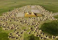 Artists conception of the site | |
  | |
| Location | Northwest of the junction of Emerald Mound Grange and Midgley Neiss Rd., Lebanon, Illinois |
|---|---|
| Coordinates | 38°37′50″N 89°47′9″W / 38.63056°N 89.78583°WCoordinates: 38°37′50″N 89°47′9″W / 38.63056°N 89.78583°W |
| Area | 145 acres (59 ha) |
| NRHP reference # | 71001026[1] |
| Added to NRHP | October 26, 1971 |
The Emerald Mound and Village Site (Emerald Site) is a pre-Columbian archaeological site located northwest of the junction of Emerald Mound Grange and Midgley Neiss Roads in St. Clair County, Illinois. The site includes five mounds, two of which have been destroyed by modern activity, and the remains of a village. Middle Mississippian peoples inhabited the village, which was a satellite village of Cahokia. The largest of the mounds is a two-tiered structure that stands 50 feet (15 m) high; its square base is 300 feet (91 m) across, while its upper tier is 150 feet (46 m) across. At the time of its discovery, the mound was the second-largest known in Illinois after Monks Mound at Cahokia.[2]
The site was added to the National Register of Historic Places on October 26, 1971.[1]
References
- 1 2 National Park Service (2010-07-09). "National Register Information System". National Register of Historic Places. National Park Service.
- ↑ Reed, Nelson A. National Register of Historic Places Inventory/Nomination: Emerald Mound and Village Site. National Park Service, 1969-09-12.
| Topics | |
|---|---|
| Lists by states |
|
| Lists by insular areas | |
| Lists by associated states | |
| Other areas | |
| |
| Wikimedia Commons has media related to Emerald Mound and Village, Illinois. |