Mattupetty Dam
| Mattupetty Dam മാട്ടുപെട്ടി അണക്കെട്ട് | |
|---|---|
 | |
 Location of Mattupetty Dam മാട്ടുപെട്ടി അണക്കെട്ട് in India  Mattupetty Dam (Kerala)  Mattupetty Dam (Tamil Nadu) | |
| Location | Munnar, Kerala, India |
| Coordinates | 10°06′22″N 77°07′26″E / 10.106°N 77.124°ECoordinates: 10°06′22″N 77°07′26″E / 10.106°N 77.124°E |
| Construction began | 1949 |
| Opening date | 1953 |
| Construction cost | Rs. 220 Lakhs |
| Operator(s) | Government of Kerala |
| Reservoir | |
| Creates | Mattupetty |
| Total capacity | 55.4 Million Cubic Meter |
| Catchment area | 105 Square kilometer |
| Surface area | 323.75 Hectare |
| Power Station | |
| Hydraulic head | 46.6 meter |
 |
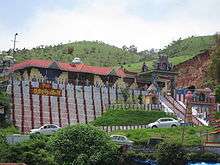
Om Saravana Bhavan Temple at Munnar in Idukki, Kerala
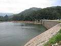
Mattupetty Dam (Madupetty Dam), near Munnar in Idukki District, is a storage Concrete Gravity dam built in the mountains of Kerala, India to conserve water for hydroelectricity.[1] It has been a vital source of power yielding along with other such dams, huge revenue to the states. The large amount of perennially available water allows wild animals and birds to flourish. However salinity caused by irrigation and water-logging are of concern to environmentalists.[2]
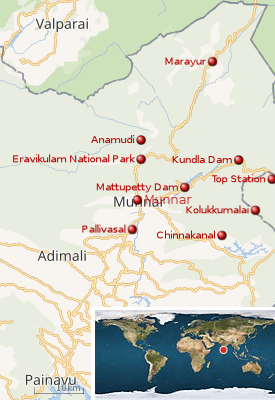
Munnar is located near the confluence of the mountain streams of Muthirappuzha River, Chanduvarai River and Kundale River. See:map
The reservoir is also known to be one of the visiting grounds of elephants in the region.


See also
Notes
- ↑ "Munnar".
- ↑ "Keyword is planning". Retrieved 2007-03-28.
External links
| Wikimedia Commons has media related to Mattupetty Dam. |
This article is issued from
Wikipedia.
The text is licensed under Creative Commons - Attribution - Sharealike.
Additional terms may apply for the media files.