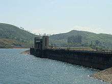
Solaiyar Dam
| Solaiyar Dam | |
|---|---|
 Solaiyar Dam | |
| Official name | Solaiyar Dam |
| Country | India |
| Location | Valparai, Tamil Nadu |
| Opening date | 1965 |
| Dam and spillways | |
| Impounds | Chalakkudi River |
| Height (foundation) | 66 metre |
| Length | 430.6 metre |
| Reservoir | |
| Creates | Chalakkudi River |
| Total capacity | 153.60 million cubic metre |
| Active capacity | 150.20 million cubic metre |
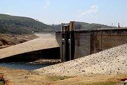
The Solaiyar Dam is part of the Solaiyar Hydroelectric Project (HEP). The project comprises the main Soliayar Dam, the Solaiyar Flanking, and the Solaiyar Saddle Dam.
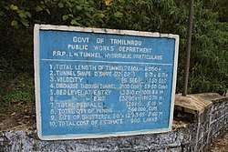
Upper Solaiyar or Upper Sholayar Dam (சோழையார் Shozhaiyaar) is located 20 km (12 mi) from Valparai, a hill station in the Anaimalai Hills of the Coimbatore district, Tamil Nadu India. As it is a part of the hydroelectric project of Tamil Nadu, special permission is required to visit the dam.
Valparai is located 64 km (40 mi) from Pollachi and 55 km (34 mi) from Chalakudy, Kerala. The nearest railway station is Chalakkudy.
The Solaiyar dam is a vital reservoir under the Parambikulam Aliyar Project and has a water storage capacity of 160 ft (49 m). The reservoir's overflowing waters are let into the Parambikulam Reservoir through the saddle dam.[1]
It was constructed by a team working under K. Palanisamy, the most popular engineer in that area.
History
Solaiyar Dam was officially opened in 1965; the Solaiyar Flanking was built in 1964 and the Solaiyar Saddle Dam in 1965.[2]
Construction
The area of the reservoir is 8.705 square km[2]. The height of the main dam is 66 metres, its width is 430 metres, and length 430.60 metres[2]. The Solaiyar Flanking has a height of 28 metres and width of 19 metres[2]. The Solaiyar Saddle Dam is 259 metres high and 109 metres wide[2].
See also
References
- ↑ "Sholayar reservoir overflows; farmers rejoice". The Hindu. 19 August 2006. Archived from the original on 2013-01-25. Retrieved 3 October 2017.
- 1 2 3 4 5 Mathew Roy, Roy. "Fact File on Major Dams owned by Kerala State Electricity Board". Expert Eyes. Retrieved 3 October 2017.
| Wikimedia Commons has media related to Solaiyar Dam. |
Coordinates: 10°19′17″N 076°44′07″E / 10.32139°N 76.73528°E