Illickal Kallu
| Illikkal rock | |
|---|---|
| Tourist destination | |
.jpg) Illikkal rock | |
| Coordinates: 9°46′3″N 76°45′3″E / 9.76750°N 76.75083°ECoordinates: 9°46′3″N 76°45′3″E / 9.76750°N 76.75083°E | |
| Country |
|
| State | Kerala |
| District | Kottayam |
| Government | |
| • Type | Panchayat |
| • Body | Moonnilavu |
| Area | |
| • Total | 33.41 km2 (12.90 sq mi) |
| Elevation | 1,830 m (6,000 ft) |
| Languages | |
| • Official | Malayalam, English |
| Time zone | UTC+5:30 (IST) |
| PIN | 686586 |
| Vehicle registration | KL-35 |
| Nearest city | Moonnilavu, Erattupetta |
Illikkal Kallu is a major attraction in Moonnilavu village of Meenachil taluk in the Kottayam district of Kerala, India. Situated 6000 feet above sea level, Illickal Kallu is a rock situated above Illickal Mala. What makes this rock unique is that half of the rock has fallen off, and only the other half remains. The nearest town to this spot is Teekoy. Numerous mountain streams in this peak, flow down to form the Meenachil River. Tourists must trek <1 km to reach the summit of the peak.
Illikkal Kallu comprises three hills, each rising to 4,000 ft above sea level. Each of the hills has a peculiar shape. One of them resembles a mushroom, which is why it is known as Kuda Kallu (umbrella-shaped rock). The beauty and the landscape of illikkal kallu is similar to the pillar rocks in Kodaikanal. It is said that the medicinal herb Neela Koduveli grows here. This blue flower is also believed to possess supernatural powers, which could increase wealth and ensure a rich harvest. The second hill has a small hunch on the sides and is therefore referred to as Koonu Kallu (hunch back rock). Across this rock is a 1⁄2-foot-wide bridge called Narakapalam (bridge to hell).
From the hilltops, the Arabian Sea can be seen in the over the horizon as a thin blue stroke. The view of the sunset from above the peak on the evening of a full moon day can be sensational: the moon can be seen rising up like another sun, as the orange sun goes down.
Tourism
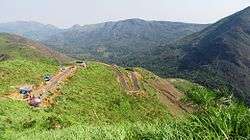
Illikal Kallu View Point: Illikkal Kallu or Illikal Rock is a common spot for people all around Kerala. The view from illikal kallu is mesmerizing with numerous hills rising to the clouds and the deep valleys. DTPC(District Tourism Promotion Council) has em-placed a check-post <1 km before the summit and private vehicles are not allowed after this point. Visitors needs to pay entry fees and parking fees at the counter here and can opt for a walk to the summit or utilize Jeep safaris provided by DTPC to reach the top. Another thing to note here is that, the entry to the top of the peak via Narakapalam is currently restricted due to a tragedy, which leads to the death of a fellow traveler in 2017. Any thereafter, proper fencing is added to the top of the view point in order to avoid any dangerous situations.
Kattikayam Waterfalls is very near to the place at a distance not more than 2 kilometers from Illikkal Kallu. A trek of about 2km to the falls is indeed a mesmerizing experience. Though there are no risks in visiting this waterfalls, visitors need to take care of slippery rocks.
Ilaveezhapoonchira is another nearby attraction which is only 7 kilometers away from Illikkal Kallu. The road to Ilaveezhapoonchira is not paved and can be considered for an off-road adventure. Ilaveezhapoonchira means ‘valley where leaves don’t fall’. The highest point is known as Kannadipara. Valley of this rocky mountain reflects the morning sun with mirror-like perfection. Pazhakakanam plateau with bamboo groves, meadows & wildflowers nourished by Thodupuzha river & Kazhukankulimali waterfalls is nearby. During monsoons, the valley fills up to form a scenic landscape that attracts tourists from all around Kerala.
Vagamon: Another nearby attraction, a hill station and one of its kind in Kerala. National Geographic Traveler has listed Vagamon on their directory of the "50 most attractive places to visit in India".
References
- http://travel.manoramaonline.com/travel/getting-around-kerala/illikkal-kallu-trek-backpack-adventure-mountain-travel.html - Travel review of Illikal Kallu
- https://www.tripadvisor.in/Attraction_Review-g297634-d8059488-Reviews-Illikkal_Kallu-Kottayam_Kerala.html - Trip advisor page of Illikal kallu
- http://www.keralatrips.co.in/2015/06/illickal-kallu-poonjar-kottayam.html
- http://travelmeout.com/illikkal-kallu-trekking-view-point/ -Travel guide on Illikal Kallu
- https://www.facebook.com/Illikkal-kallu-774834225860529/ - Facebook page of illikal kallu
External links
| Wikimedia Commons has media related to Illickal Kallu. |
- http://www.illikkalkallu.com/ - the official website of illikal Kallu
- https://enteyathrakal.com/illickal-kallu/ - Illikal Kallu Travelogue
- http://healthacation.com/ - Healthacation official website