Masindi Airport
| Masindi Airport | |||||||||||
|---|---|---|---|---|---|---|---|---|---|---|---|
| Summary | |||||||||||
| Airport type | Public | ||||||||||
| Owner | Civil Aviation Authority of Uganda | ||||||||||
| Serves | Masindi | ||||||||||
| Location | Masindi, Uganda | ||||||||||
| Elevation AMSL | 3,850 ft / 1,173 m | ||||||||||
| Coordinates | 01°45′18″N 031°44′12″E / 1.75500°N 31.73667°ECoordinates: 01°45′18″N 031°44′12″E / 1.75500°N 31.73667°E | ||||||||||
| Map | |||||||||||
 HUMI Location of Masindi Airport in Uganda | |||||||||||
| Runways | |||||||||||
| |||||||||||
|
Sources: Great Circle Mapper[1] | |||||||||||
Masindi Airport (IATA: KCU, ICAO: HUMI) is an airport in Uganda.
Location
Masindi Airport is in the Kyema suburb of the town of Masindi, Masindi District, Bunyoro sub-region, in the Western Region. It is approximately 199 kilometres (124 mi), by air, north-west of Entebbe International Airport, the country's largest civilian and military airport.[2] This is approximately 10 kilometres (6 mi), by road, directly north of the central business district of the town.[3]
The Masindi non-directional beacon (ident: MS) is within the town, approximately 6 kilometres (3.7 mi) south of the Runway 01 threshold.[4]
See also

- List of airports in Uganda
- Transport in Uganda
- Civil Aviation Authority of Uganda
References
- ↑ Airport information for Masindi Airport - Great Circle Mapper
- ↑ "Flight Distance Between Entebbe Airport And Masindi Airport With Map". Distance Calculator. Globefeed.com. Retrieved 2 August 2011.
198.72 km
- ↑ "Distance between , and Kyema (Masindi) (Uganda)". distancecalculator.globefeed.com. Retrieved 2018-08-29.
- ↑ "SkyVector: Flight Planning / Aeronautical Charts". skyvector.com. Retrieved 2018-08-29.
External links
- Location of Masindi Airport At Google Maps
- Masindi pilot info
- Website of Uganda Civil Aviation Authority
Capital: Masindi | ||
| Towns and villages | 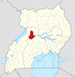 | |
| Geography | ||
| Economy | ||
| Energy | ||
| Notable landmarks |
| |
| Health | ||
| Transport | ||
| Notable people | ||
This article is issued from
Wikipedia.
The text is licensed under Creative Commons - Attribution - Sharealike.
Additional terms may apply for the media files.