Kakira Airport
| Kakira Airport | |||||||||||
|---|---|---|---|---|---|---|---|---|---|---|---|
| Summary | |||||||||||
| Airport type | Private & civilian | ||||||||||
| Owner | Madhvani Group | ||||||||||
| Serves | Kakira, Uganda | ||||||||||
| Elevation AMSL | 3,960 ft / 1,207 m | ||||||||||
| Coordinates | 00°29′56″N 033°16′57″E / 0.49889°N 33.28250°ECoordinates: 00°29′56″N 033°16′57″E / 0.49889°N 33.28250°E | ||||||||||
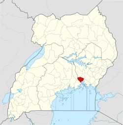
| Map | |||||||||||
 HUKK Location of airport in Uganda | |||||||||||
| Runways | |||||||||||
| |||||||||||
Kakira Airport (ICAO: HUKK) is one of the 46 airports in Uganda.[1] It is in Kakira, Jinja District, Eastern Region. The geographic coordinates of this airport are 00 degrees, 29 minutes, 56 seconds north and 33 degrees, 16 minutes, 57 seconds east (latitude: 0.4990; longitude: 33.2825). It is approximately 107 kilometres (66 mi), by air, east of Entebbe International Airport, the country’s largest civilian and military airport.[2]
The airport is adjacent to the Kakira Sugar Factory and within the Kakira estate close to the main family residences on the Madhvani estate. It is a small private, civilian airport that serves the town of Kakira and the Madhvani Group. Its operations are privately administered and, as of December 2009, not by the Uganda Civil Aviation Authority.[3]
Facilities
The airport is 3,960 feet (1,207 m) above sea level and has a single paved runway that is 1,280 metres (4,199 ft) in length.[4]
See also
References
- ↑ "Uganda". CIA World Factbook.
Airports: 46 (2010)
- ↑ "Distance between Entebbe Airport () and Kakira (Jinja) (Uganda)". distancecalculator.globefeed.com. Retrieved 2018-08-29.
- ↑ Kakira Airport Not Administered by the Uganda CAA Archived 2010-02-16 at Archive.is
- ↑ "Aeronautical chart showing HUKK with elevation and runway length". SkyVector. Retrieved 14 August 2013.
External links
- Location of Kakira Airport At Google Maps
- Uganda Civil Aviation Authority Homepage
- Aeronautical chart for HUKK at SkyVector