Jinja Airport
| Jinja Airport | |||||||||||
|---|---|---|---|---|---|---|---|---|---|---|---|
| Summary | |||||||||||
| Airport type | Civilian and military | ||||||||||
| Owner | Civil Aviation Authority of Uganda | ||||||||||
| Serves | Jinja, Uganda | ||||||||||
| Elevation AMSL | 3,840 ft / 1,170 m | ||||||||||
| Coordinates | 0°27′09″N 33°11′35″E / 0.45250°N 33.19306°ECoordinates: 0°27′09″N 33°11′35″E / 0.45250°N 33.19306°E | ||||||||||
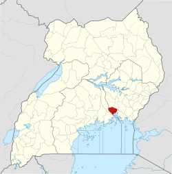
| Map | |||||||||||
 JIN Location of airport in Uganda | |||||||||||
| Runways | |||||||||||
| |||||||||||
|
Sources: SkyVector Aeronautical Charts[1] | |||||||||||
Jinja Airport (IATA: JIN, ICAO: HUJI) is a small civilian and military airport in Uganda. It serves the town of Jinja in Jinja District, Busoga, Eastern Region. It is adjacent to the Uganda Senior Command and Staff College of the Uganda People's Defence Force at Kimaka, a suburb of Jinja. It is approximately 94 kilometres (58 mi) east of Entebbe International Airport, the country’s largest airport.[2]
Jinja Airport is one of twelve upcountry airports that are administered by the Uganda Civil Aviation Authority.[3]
See also


- List of airports in Uganda
- Transport in Uganda
References
- ↑ "Aeronautical chart showing HUJI with elevation and runway length". SkyVector. Retrieved 14 August 2013.
- ↑ "Distance between Entebbe Airport () and Jinja () (Uganda)". distancecalculator.globefeed.com. Retrieved 2018-08-29.
- ↑ "Aerodromes". Uganda Civil Aviation Authority. Archived from the original on 2010-02-16.
External links
This article is issued from
Wikipedia.
The text is licensed under Creative Commons - Attribution - Sharealike.
Additional terms may apply for the media files.