Maryamin, Homs
| Maryamin مريمين Mariamin | |
|---|---|
| Village | |
 Maryamin Location in Syria | |
| Coordinates: 34°53′06″N 36°26′20″E / 34.88498°N 36.438816°ECoordinates: 34°53′06″N 36°26′20″E / 34.88498°N 36.438816°E | |
| Country |
|
| Governorate | Homs |
| District | Homs |
| Subdistrict | Taldou |
| Population (2018) | |
| • Total | ~12‘000 |
| Time zone | UTC+2 (EET) |
| • Summer (DST) | UTC+3 (EEST) |
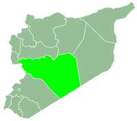
Maryamin (Arabic: مريمين, also spelled Mariamin or Meriamen) is a village in central Syria, administratively part of the Homs Governorate starting from 2008 after being part of the Hama Governorate,[1] located in Homs Gap southwest of Hama. Nearby localities include Aqrab, Nisaf and Baarin to the north, Kafr Kamrah and Mashta al-Helu to the west, Shin, al-Shinyah and al-Qabu to the south, and Taldou and Tell Dahab to the east. According to the Syria Central Bureau of Statistics, Maryamin had a population of 4,174 in the 2004 census.[2] Its inhabitants are predominantly Alawites.[3][4]
History
Maryamin is believed to be located on the site of a town founded by Ramses II of the New Kingdom of Egypt.[6]
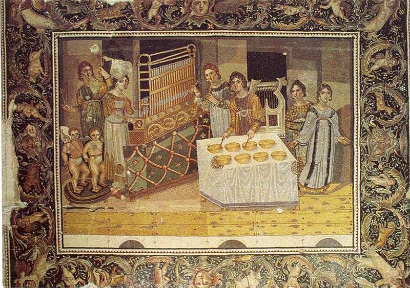
Maryamin, or ancient "Mariamme", was mentioned by Pliny the Elder and in late Roman lists.[7] The town likely served as the capital of the Mariamnitai tribe,[8] but very little mention of the Roman town survives.[7] The Roman Catholic Church still maintains a titular "Bishop of Mariamme". An important late forth-century mosaic from the Byzantine era was discovered in the ruins of a villa in Maryamin in 1960.[9] The mosaic has an area of 20 square meters and depicts six female musicians playing instruments. The depiction is one of the few artifacts that give an indication on how the organ instrument was used in the ancient period.[10] The mosaic is currently displayed at the regional museum of Hama.[9]
The Syrian geographer Yaqut al-Hamawi noted that Maryamin was "one of the villages of Hims" when he visited in 1225, during Ayyubid rule.[11]
In 1929 Maryamin and a number of other Alawite villages in the Masyaf district were transferred to the Alawite State after negotiations with their landlords. The villages' cultivated lands were distributed among the peasantry that worked them.[12] In the early 1960s Maryamin had a population of 600 residents. It was a center for growing grape vines and contained a number of springs.[6]
References
Notes
- ↑ مريمين"... زهرة الجبل"
- ↑ General Census of Population and Housing 2004 Archived 2013-01-13 at Archive.is. Syria Central Bureau of Statistics (CBS).
- ↑ Smith, 1841, p. 180.
- ↑ What happened in Houla?. Al Jazeera English. 2012-01-16.
- ↑ Ring, Trudy (1994), International Dictionary of Historic Places: Middle East and Africa, 4, Taylor & Francis, ISBN 1884964036
- 1 2 Boulanger, 1966, p. 453.
- 1 2 Butcher, 2003, p. 110.
- ↑ Butcher, 2003, p. 89.
- 1 2 Braun, 2002, p. 286.
- ↑ Ring, 1994, p. 318.
- ↑ le Strange, 1890, p. 503.
- ↑ Bosworth, 1989, p. 791.
Bibliography
- Bente Kiilerich, 'The Mosaic of the Female Musicians from Mariamin', Acta ad archaeologiam et artium historiam pertinentia XXII, n.s. 8, 2010, 87-107.
- Bente Kiilerich, 'Mariamin Mosaic', in P.C. Finney, ed., The Eerdmans Encyclopedia of Early Christian Art and Archaeology, Grand Rapids, Mi.,2017, vol. II, p. 107.
- Clifford Edmund, Bosworth (1989). The Encyclopaedia of Islam: Fascicules 111-112 : Masrah Mawlid, Parts 111-112. BRILL. ISBN 9004092390.
- Boulanger, Robert (1966). The Middle East, Lebanon, Syria, Jordan, Iraq, Iran. Hachette.
- Braun, Joachim (2002). Music in Ancient Israel/Palestine: Archaeological, Written, and Comparative Sources. Wm. B. Eerdmans Publishing. ISBN 0802844774.
- Butcher, Kevin (2003). Roman Syria: And the Near East. Getty Publications. ISBN 9780892367153.
- Ring, Trudy (1994). International Dictionary of Historic Places: Middle East and Africa. 4. Taylor & Francis. ISBN 1884964036.
- Smith, Eli; Robinson, Edward (1841). Biblical Researches in Palestine, Mount Sinai and Arabia Petraea: A Journal of Travels in the Year 1838. 3. Crocker and Brewster.
- le Strange, Guy (1890). Palestine Under the Moslems: A Description of Syria and the Holy Land from A.D. 650 to 1500. Committee of the Palestine Exploration Fund.
|  | |||||||||||||||||||||||||||||
|
| ||||||||||||||||||||||||||||||
| ||||||||||||||||||||||||||||||
| ||||||||||||||||||||||||||||||
| ||||||||||||||||||||||||||||||