Bungonia, New South Wales
| Bungonia New South Wales | |||||||||||||||
|---|---|---|---|---|---|---|---|---|---|---|---|---|---|---|---|
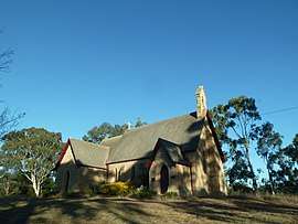 Christ Church Anglican Church in Bungonia | |||||||||||||||
|
Bungonia | |||||||||||||||
| Coordinates | 34°51′S 149°57′E / 34.850°S 149.950°ECoordinates: 34°51′S 149°57′E / 34.850°S 149.950°E | ||||||||||||||
| Population | 367 (2016 census)[1] | ||||||||||||||
| Postcode(s) | 2580 | ||||||||||||||
| Location | |||||||||||||||
| LGA(s) | Goulburn Mulwaree Council | ||||||||||||||
| Region | Southern Tablelands | ||||||||||||||
| County | Argyle | ||||||||||||||
| Parish | Bungonia | ||||||||||||||
| State electorate(s) | Goulburn | ||||||||||||||
| Federal Division(s) | Hume | ||||||||||||||
| |||||||||||||||
Bungonia is a small town in the Southern Tablelands in New South Wales, Australia in Goulburn Mulwaree.[2][3] At the 2016 census, Bungonia had a population of 367.[1] The name of the town derives from an Aboriginal word meaning 'sandy creek'.[2]
It was originally called Inverary. A post office opened at Inverary in 1832 and was renamed Bungonia in 1836. When the Great South Road (now the Hume Highway) bypassed the town, Bungonia ceased to grow beyond a very small village.
Heritage listings
Bungonia has a number of heritage-listed sites, including:
- King Street: Christ Church Anglican Church[4]
See also
References
- 1 2 Australian Bureau of Statistics (27 June 2017). "Bungonia (State Suburb)". 2016 Census QuickStats. Retrieved 10 July 2016.

- 1 2 "Bungonia". Geographical Names Register (GNR) of NSW. Geographical Names Board of New South Wales. Retrieved 10 August 2017.
- ↑ "Bungonia". OpenStreetMap. Retrieved 10 August 2017.
- ↑ "Christ Church Anglican, New South Wales State Heritage Register (NSW SHR) Number H01303". New South Wales State Heritage Register. Office of Environment and Heritage. Retrieved 18 May 2018.
- Exploring the ACT and Southeast New South Wales, J. Kay McDonald, Kangaroo Press, Sydney, 1985 ISBN 0-86417-049-1
External links
| Towns | |
|---|---|
| Localities and rural places |
|
Main Article: Local government areas of New South Wales | |
This article is issued from
Wikipedia.
The text is licensed under Creative Commons - Attribution - Sharealike.
Additional terms may apply for the media files.