Majhdia
| Majhdia | |
|---|---|
| Village | |
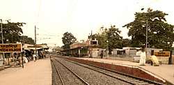 Majdia Railway station | |
 Majhdia Location in West Bengal, India | |
| Coordinates: 23°24′54″N 88°43′11″E / 23.4149°N 88.7196°ECoordinates: 23°24′54″N 88°43′11″E / 23.4149°N 88.7196°E | |
| Country |
|
| State | West Bengal |
| District | Nadia |
| Elevation | 14 m (46 ft) |
| Population (2011) | |
| • Total | 11,995 |
| Languages | |
| • Official | Bengali, English |
| Time zone | UTC+5:30 (IST) |
| Lok Sabha constituency | Ranaghat |
| Vidhan Sabha constituency | Krishnaganj |
| Website |
nadia |
Majdia, also known as Majhdia, is a developed village in Krishnaganj CD Block in Krishnanagar Sadar subdivision of Nadia district, West Bengal, India. This village is under Krishnaganj police station. Mango and yammy khejur gur is the most attraction for Majdia City.[1]
Demographics
As per the 2011 Census of India, Majhdia had a total population of 11,995, of which 6,112 (51%) were males and 5,883 (49%) were females. Population below 6 years was 1,163. The total number of literates in Majhdia was 8,315 (76.76% of the population over 6 years).[2]
CD Block HQ
The headquarters of Kaliganj CD Block are located at Majhdia.[3]
Education
Majhdia college knowned as Sudhiranjan Lahiri Mahavidyalaya is situated here. Majdia Rail Bazar High School and Shib Mohini Kanya Vidyapith are the schools, providing 10+2 education to the locals. There are few primary schools in the locality.
Transport
SH 8, originates from Majhdia and runs to Santaldih (in Purulia district).[4]
Majdia is connected by railway with Kolkata through the Sealdah–Ranaghat - Gede line. Bus services are frequently available towards district sadar Krishnagar and Ranaghat town.
References
- ↑ Majdia. "INDIAN VILLAGE DIRECTORY". villageinfo.in. Retrieved 18 March 2017.
- ↑ "2011 Census – Primary Census Abstract Data Tables". West Bengal – District-wise. Registrar General and Census Commissioner, India. Retrieved 18 May 2017.
- ↑ "District Census Handbook: Nadia, Series 20 Part XII A" (PDF). Map of Nadia with CD Block HQs and Police Stations (on the fourth page). Directorate of Census Operations, West Bengal, 2011. Retrieved 2 May 2017.
- ↑ "List of State Highways in West Bengal". West Bengal Traffic Police. Retrieved 5 May 2017.
Cities, towns and locations in Nadia District | |||||||||
|---|---|---|---|---|---|---|---|---|---|
| Cities, municipal and census towns |
| ||||||||
| Locations other than cities and towns |
| ||||||||
| Related topics |
| ||||||||