Badkulla
| Badkulla | |
|---|---|
| Census Town | |
 Badkulla railway station | |
 Badkulla Location in West Bengal, India | |
| Coordinates: 23°17′N 88°32′E / 23.28°N 88.53°ECoordinates: 23°17′N 88°32′E / 23.28°N 88.53°E | |
| Country |
|
| State | West Bengal |
| District | Nadia |
| Elevation | 9 m (30 ft) |
| Population (2017) | |
| • Total | 22,061 |
| Languages | |
| • Official | Bengali, English |
| Time zone | UTC+5:30 (IST) |
| PIN | 741121 |
| Telephone code | 91 3473 |
| Vehicle registration | WB 52 |
| Sex ratio | 1:1 ♂/♀ |
| Lok Sabha constituency | Ranaghat |
| Vidhan Sabha constituency | Krishnaganj |
Badkulla[1] is a Census Town in Hanskhali CD Block in Ranaghat subdivision of Nadia district in the Indian state of West Bengal. It is situated at a distance of 10 kilometers from district headquarters Krishnagar and approximately 80 kilometers from Kolkata. Now it is a semi town but growing with a high throttle it will become a complete town soon by the economical assistance of Rice Mill and Steel Furniture factories. It comes under krishnaganj (sc) Legislative Assembly and Ranaghat (sc) Lokshabha.
History
According to the senior citizens of Badkulla, previously Badkulla was under the king of Krishnagar, Raja Krishnachandra Roy. Being glad to the people of Badkulla, Raja Krishnachandra freed them from giving Tax. (Bengali: কর). In old Bengali the word Bengali: কর was "KULLA" (Bengali: কুল্লা and "Bengali: বাদ)" means no or not. As the people of Badkulla were not giving Bengali: কর(tax) Raja Krishnachandra named the place "BADKULLA". Since then the name of Badkulla was originated. Many veteran residents of Badkulla usually say present Badkulla Railway Station was situated at Patua Railway gate.
Geography
Badkulla is located at 23°17′N 88°32′E / 23.28°N 88.53°E.[2] It has an average elevation of 9 metres (30 feet). Nadia district is mostly alluvial plains lying to the east of Hooghly River, locally known as Bhagirathi River. The alluvial plains are cut across by such distributaries as Jalangi, Churni and Ichamati River. With these rivers getting silted up, floods are a recurring feature. The Anjana river has gone through Badkulla. Though at present, it can hardly be recognized as a river due to immense pollution and population. But it is believed that once the great poet Rabindranath Tagore had come and wrote a poem about the Anjana river and a temple beside it. That temple can still be found beside the Anjana river.[3]
Education
In 2017, Badkulla got Global Providence Academy as its first English-medium school. Besides, there are some Bengali-medium high schools, one for boys, one for girls and the others are Co-Education Moreover, there are about more than 20 primary schools and 4 K.G. Nursery Schools under Shishu Mangal Parsad. There is a Govt-sponsored Town Library here named Rani Bhawani Pathagar. There is no college in Badkulla.
Higher Secondary Schools:
- Badkulla United Academy (Higher Secondary)
- Surabhistan Bhuvan Mohini Girls' High School (Higher Secondary)
- Anjangarh High School (H.S)
- Bapuji Nagar High School (H.S)
- Arbandi High School (H.S)
- Khamarshimulia High School (H.S)
Primary Schools:
- Goruapota junior high school
- Goruapota primary school
- Surabhistan GSF Primary School
- Badkulla Primary School (Under BUA)
- Ballabhpur Primary Schools
- Patuli Primary School
- Anjangarh Primary School
- Nowpukuria Primary School
- Dakshin Chandra Rupantarit Nimno Buniyadi Prathomik Vidyalay
- Dakshin Chandra SSKM
- Patua Primary School
- Ashrampara Primary School
- Charkatala Primary School
- Gangni Primary School
- Dosatina Converted Junior Basic School
- Puradarpur primary school
- Surabhistann GSF Primary School
- Global Providence Academy (English-medium) http://gpainstitution.com/
- Mousumi Adarsha Primary School
- Kaya Adarsha Shiksha Niketon
- Krishna Computer And Mobile Gangni
Demographics
As per the 2011 Census of India, Badkulla had a total population of 18,051, of which 9,140 (51%) were males and 8,911 (49%) were females. Population below 6 years was 1,497. The total number of literates in Badkulla was 14,264 (86.17% of the population over 6 years).[4]
Festivals
Badkulla is famous in the district for small-scale weaving industry and large pandals during Durga-Puja. During the four days of Durga-Puja Badkulla becomes alive. Every year thousands of people gather here from the nearby places to see the huge pandals, beautiful light works, amazing idols. Once upon a time here Durgapuja was started after getting sound of Cannon from the Royal Palace of Krishnachandra of Krishnagar. Apart from the Durga-Puja, it also well known for its cultural devotion. Here all the clubs organize annual functions to encourage the common people to take participation in different social and cultural events. Local clubs of the area organised Durgapuja.
Laxmi Puja, Rathyatra and Rashyatra is also very famous of here. Some volunteer web-developers of Badkulla have created a website (www.badkulladurgapuja.net ) of Badkulla Durgapuja to share it with the world.[5]
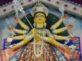 Durga Puja
 Lighting of puja Pandel
 Pandel of Anami Club, 2011 based on Akshay Dham Mandir
 Puja pandel
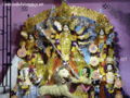 Age-old Baroari Puja of Badkulla
Transport

The local train is the most convenient way to reach Badkulla. It would take around more than 2 hours to reach Kolkata both by rail and road. Another way to reach here is Bus (Bus no 17B) of Krishnagar-Ranaghat (via Badkulla) State Highway 11, passes through here. Third way is Trekker and Auto ricshaw from Phulia, Dignagar, Hanskhali, Chitashali-Itaberia, Aranghata and Bagula. Moreover, for internal communication Auto rickshaw and Cycle rickshaw is available. Badkulla is also accessible through National Highway 34, which is around 6 kilometres (3.72 mi) away. Netaji Subhas Chandra Bose International Airport, located around 70 kilometres (43 mi) south, operates domestic and international flights.
Health and security
Badkulla Rural Hospital is the only government health center of Badkulla. 4 posted doctors, 8 Nurses, 9 group D staffs and 1 Ambulance are there to provide medical service to the people of Badkulla locality. It has 30 bed capacity which is very low. There is one private nursing home named Nabadeepto nursing home. This area is under the Taherpur police Station and Badkulla Police Fandi (Camp).
References
| Wikimedia Commons has media related to Badkulla. |
- ↑ "Badkulla". www.badkulla.com. Retrieved 2018-05-22.
- ↑ Falling Rain Genomics, Inc - Badkulla
- ↑ Gangopadhyay, Basudev, Paschimbanga Parichay, 2001, (in Bengali), p. 70, Sishu Sahitya Sansad
- ↑ "2011 Census – Primary Census Abstract Data Tables". West Bengal – District-wise. Registrar General and Census Commissioner, India. Retrieved 18 May 2017.
- ↑ Website of Badkulla Durgapuja
Cities, towns and locations in Nadia District | |||||||||
|---|---|---|---|---|---|---|---|---|---|
| Cities, municipal and census towns |
| ||||||||
| Locations other than cities and towns |
| ||||||||
| Related topics |
| ||||||||