Bagula
| Bagula বগুলা | |
|---|---|
| Census Town | |
 Bagula Location in West Bengal, India  Bagula Bagula (India) | |
| Coordinates: 23°20′06″N 88°38′38″E / 23.335°N 88.644°ECoordinates: 23°20′06″N 88°38′38″E / 23.335°N 88.644°E | |
| Country |
|
| State | West Bengal |
| District | Nadia |
| Area | |
| • Census Town | 4.25 km2 (1.64 sq mi) |
| • Urban | 6 km2 (2 sq mi) |
| Elevation | 6 m (20 ft) |
| Population (2011) | |
| • Census Town | 22,649 |
| • Density | 5,300/km2 (14,000/sq mi) |
| • Urban | 90,000 |
| Languages | |
| • Official | Bengali, English |
| Time zone | UTC+5:30 (IST) |
| PIN | 741502 |
| Telephone code | 03473 |
| Sex ratio | 1.06 ♂/♀ |
Bagula is a Census Town in Hanskhali CD Block in Ranaghat subdivision of Nadia district in West Bengal, India. It is 93 km from Kolkata.
Geography
Bagula is located at 23°20′06″N 88°38′38″E / 23.335°N 88.644°E.[1] It has an average elevation of 6 metres (20 feet).
Bagula is known for Akanno (51) Pith Kali Pujar Mela, which is held in a famous Cremation area situated beside the railway station. This Village also has a Post Office ( Bagula Post Office) and cultural Hall. The people of surrounding villages (e.g. Durgapur, Harindanga, Haritala, Koikhali, Panditpur, Bara Chupria, Garapota, Bhawanipur, Kuti Para, Gour Nagar, Mura Gacha, Haldi para) are connected with Bagula for their daily needs, transport and banking.
Demographics
As per the 2011 Census of India, Bagula had a total population of 22,649, of which 11,631 (51%) were males and 11,018 (49%) were females. Population below 6 years was 1,972. The total number of literates in Bagula was 18,299 (88.50% of the population over 6 years).[2]
CD Block HQ
The headquarters of Hanskhali Community Development Block is situated at hanskhali.[3]
Education
Bagula is an educated area. Near about 70% people are service holder in Government and private sector. In between Bagula panchyat (I and II) there is a college, 8 High School and 12 Primary School (Up to class Five) and in between these school all High school and 8 primary school are government sponsored. Srikrishna College of Bagula is a notable educational institution of West Bengal.[4] Notable schools are Bagula Higher Secondary School, Bagula Purbapara Higher Secondary School, H.C.S.C. Srikrishna Balika Bidyapith.Ramnagar High School(H.S),Bhawanipur High School, Haritala High School, Muragachha High School,Ulasi J.S.Vidyapith, Patikabari High School, Hanskhali Samabay Vidyapith (H.S.), Haldipara High School, Bhyana High School, Taraknagar Jamuna Sundari High School, Garapota High School, Gazna High School,etc. And many Primary Schools. There is also an English medium preschool Kids Academy and many K.G. Schools, they are named Bagula Kids Academy followed by I.C.S.E curriculum,Shri Hari Shishu Niketan, Smritikona Juvenile Academy.Another school named Bagula Public School has been opened upto class V, it runs strictly on C.B.S.E curriculum with huge area and possibilities in recent future.
Transport
Bagula had been an important meeting point for the cargo and human transport during the British era especially from the advent of rail connectivity (CE.1862). It was an important point of transportation towards Krishnanagar, the district headquarter until Krishnanagar got railway connectivity. The name of station is immortalized by the Bengali Bard Rabindranath Thakur in his famous novel 'Noukadubi'. Bagula is connected by Road, Railways. The local train connects Bagula with Kolkata via Ranaghat. A few notable halt stations en route to Ranaghat are Bhayna, Bahirgachhi, Aranghata, Panchbaria, Bankimnagar. Although notable halt stations come en route to Gede are Harishnagar, Banpur, Majdia, Taraknagar and Mayurhat. Although it connects to Gede at Indo Bangladesh Border through Train via Maitri Express. Gede-Sealdah Route is the main route of Sealdah section. Bagula also connects Ranaghat and Krishnanagar by bus as well. Bus route to Kishnnagar is via Hanshkhali, which is known for Churni river. Now there is available road transport directly to Bagula from Ranaghat beside the train line. It takes maximum half an hour to travel to Bagula from Ranaghat by Private car or Motor bikes or small public transport (Trecker, Auto, Tata Magic etc.).
Health and security
"Bagula Rural Hospital" is the only government Health center of Bagula. 2 posted doctor, 8 Nurse, 9 group D staffs and 1 Ambulance is always ready to serve their best to the people of Bagula. It has 30 bed capacity which is very low but good as something is better than nothing. There are two private nursing home named "Sanjeevani" and "Shyamali" nursing home also servicing for the people of Bagula and near about locality. There is also an Animal health center in Bagula which is government sponsored. Hanskhali police Station" and "Bagula Police Camp" serve the area.
Bank
In this town there is 10 banks namely SBI, BOI, BOB, ALBK, central bank of India, central co-opearative bank, UBI and Gramin Bank, Axis bank & co-operative bank. There are two sub branch of SBI is situated at Gazna and Haritala. In the year 2001 Bagula post office was take first place whole over the India for money transaction through "Western Union Money transfer" and Bagula SBI branch take the first place in West Bengal for their maximum business. There is about 20 ATM's of various bank situated at Bagula's main Area.
Social activities and culture
Bagula is well known for its various social and cultural activities. Lots of clubs and organisation organize different type of activities in different times throughout the whole year such as football cricket or tournaments. Those Tournament is very popular in Bagula and the locality. Even players from outside of the Bengal come to take part in this tournament through the participating club. Except this lots of cultural program happen in Bagula. Like "Puspo prodorshoni (Flower exhibition), Chatro Yuba Samiti's Program etc. Famous folk singer Late Gostho Gopal Das used to reside in Bagula at Puratan Para (Near Dhan Hata), and mesmerized person of Bengal through his melodious singing. Specially for the songs dedicated to Late Indira Gandhi and honored by Late Prime Minister Rajeev Gandhi.
Politics
Bagula is divided into two Panchyat, I and II. It comes under Ranaghat North-east legislative assembly and Ranaghat Loksabha. Political leaders has a support to updated Bagula from an unknown village to popular village at this time.
Gallery
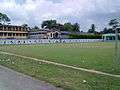 Bagula Shri Krishna College
 Panoramic view of crop field
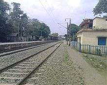 Bagula Railway Station
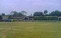 Bagula Shri Krishna College
 Bagula High School
References
- ↑ Falling Rain Genomics, Inc - Bagula
- ↑ "2011 Census – Primary Census Abstract Data Tables". West Bengal – District-wise. Registrar General and Census Commissioner, India. Retrieved 18 May 2017.
- ↑ "District Census Handbook: Nadia, Series 20 Part XII A" (PDF). Map of Nadia with CD Block HQs and Police Stations (on the fourth page). Directorate of Census Operations, West Bengal, 2011. Retrieved 2 May 2017.
- ↑ List of notable colleges of West Bengal from 123careers.net
External links
| Wikimedia Commons has media related to Bagula. |
- Seminar on Arsenic Pollution study in WB from Harvard website, retrieved 14-Aug-2208