Lyngen
| Lyngen kommune Ivggu suohkan Yykeän komuuni | |||
|---|---|---|---|
| Municipality | |||
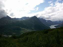 Lyngseidet, southern Lyngen Alps, and Kjosen fjord | |||
| |||
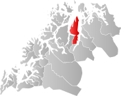 Lyngen within Troms | |||
| Coordinates: 69°41′25″N 20°04′54″E / 69.69028°N 20.08167°ECoordinates: 69°41′25″N 20°04′54″E / 69.69028°N 20.08167°E | |||
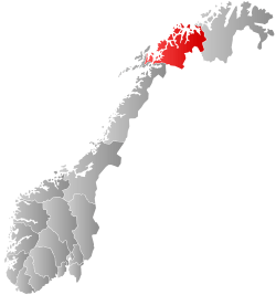
| Country | Norway | ||
| County | Troms | ||
| District | Nord-Troms | ||
| Established | 1 Jan 1838 | ||
| Administrative centre | Lyngseidet | ||
| Government | |||
| • Mayor (2015) | Dan Håvard Johnsen (Local list) | ||
| Area | |||
| • Total | 812.56 km2 (313.73 sq mi) | ||
| • Land | 795.68 km2 (307.21 sq mi) | ||
| • Water | 16.88 km2 (6.52 sq mi) 2% | ||
| Area rank | #136 in Norway | ||
| Population (2017) | |||
| • Total | 2,876 | ||
| • Rank | #274 in Norway | ||
| • Density | 3.6/km2 (9/sq mi) | ||
| • Change (10 years) | -10.1% | ||
| Demonym(s) | Lyngsfjerding[1] | ||
| Time zone | UTC+01:00 (CET) | ||
| • Summer (DST) | UTC+02:00 (CEST) | ||
| ISO 3166 code | NO-1938 | ||
| Official language form | Neutral | ||
| Website |
lyngen | ||

Lyngen (Northern Sami: Ivggu suohkan; Kven: Yykeän komuuni) is a municipality in Troms county, Norway. The administrative centre of the municipality is the village of Lyngseidet. Other villages include Furuflaten, Lattervika, Nord-Lenangen, and Svensby.
The 813-square-kilometre (314 sq mi) municipality is the 136th largest by area out of the 422 municipalities in Norway. Lyngen is the 274th most populous municipality in Norway with a population of 2,876. The municipality's population density is 3.6 inhabitants per square kilometre (9.3/sq mi) and its population has decreased by 10.1% over the last decade.[2]
General information
The parish of Lyngen was established as a municipality on 1 January 1838 (see formannskapsdistrikt law). On 1 January 1867, the southern part of Karlsøy Municipality (population: 862) surrounding the Sørfjorden (innermost part of the Ullsfjorden) was transferred to Lyngen.
Then on 1 January 1875, a small part of Lyngen (population: 7) was transferred to the neighboring Balsfjord Municipality. On 1 January 1902, the Sørfjorden area (population: 1,139) was separated from Lyngen to form a new municipality called Sørfjord. This left Lyngen Municipality with 5,102 residents. In 1929, the large municipality of Lyngen was divided into three parts. The northwestern part (population: 2,225) remained as Lyngen municipality. The northeastern part (population: 2,482) became the new Kåfjord Municipality. The southern part (population: 1,499) became the new Storfjord Municipality.
During the 1960s, there were many municipal mergers across Norway due to the work of the Schei Committee. On 1 January 1964, the municipality of Lyngen (population: 2,761) was merged with the northern part of the Lyngen peninsula that was part of Karlsøy Municipality (population: 1,001) and with the Svensby area of Ullsfjord Municipality (population: 171) to form a new, larger Lyngen Municipality. Then on 1 January 1992, the part of Lyngen Municipality located on the eastern shore of the Lyngenfjorden was removed from Lyngen. The Nordnes village area (population: 38) in the northern part of this area was transferred to the neighboring Kåfjord Municipality, and the unpopulated southern part was transferred to the neighboring Storfjord Municipality.[3]
Name
The municipality is named after the Lyngen fjord (Old Norse: Lygnir). The name of the fjord is derived from the word logn which means "quiet", "still", or "calm".[4]
Coat of arms
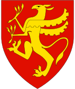
The coat of arms was granted on 11 September 1987. The arms show a black horse (a local breed called Lyngshest) on a white/silver background. The silver color symbolizes the sea and fishing industry and the horse represents the local agriculture.[5][6]
Churches
The Church of Norway has one parish (sokn) within the municipality of Lyngen. It is part of the Nord-Troms prosti (deanery) in the Diocese of Nord-Hålogaland.
| Parish (Sokn) | Church Name | Location of the Church | Year Built |
|---|---|---|---|
| Lyngen | Lyngen Church | Lyngseidet | 1782 |
| Lenangsøyra Chapel | Lyngmo | 1996 |
History

The Lyngen Church was built at Karnes in 1731, and was moved to its present location at Lyngseidet in 1740. In 1775, the church was rebuilt in its current cruciform shape, with the material from the old church used for a boathouse in Oldervik. Finally in 1840–1845, the church was renovated with a new tower, galleries, windows and panelling.[7]
Other interesting buildings include the large wooden school in Solhov, which was built in 1924 to strengthen the Norwegian influence in this area which was largely populated by the Sami and Kven people.
During the Cold War the Norwegian Army planned to abandon Finnmark and halt the Soviets along the European route E06 highway at the choke point between the Lyngen fjord and the mountains. However, there were always great worries that the Soviets would also advance through Finland and the very sparsely defended extreme north of Sweden (north of Kiruna, south of Treriksröset) and attack the Lyngen position from the rear via Signaldalen.
Geography

The municipality is situated on the Lyngen peninsula, with the Lyngen fjord to the east and Ullsfjorden to the west. The municipal centre is the village of Lyngseidet, a pretty settlement on an isthmus that almost cuts the peninsula in the middle. Other villages include Furuflaten, which has various industries, and Svensby. Nord-Lenangen faces the open sea, and is largely a fishing village. The municipality has its own shipping company, operating the car ferries west to Breivikeidet in Tromsø and east to Olderdalen in Kåfjord meeting European route E6. There is also a road going south along the shore of the fjord connecting to the main E6 road, giving ferry-free access to the main road network.
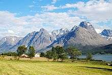
The Lyngen peninsula is a very scenic and mountainous area, known as the Lyngen Alps, with the highest peaks in Troms county. The highest peak is Jiehkkevárri, reaching 1,833 metres (6,014 ft). Another prominent mountain is Store Lenangstind. The Strupbreen lies in this mountain range, northwest of Lyngseidet. The Lyngen Alps are presently being discovered by off-piste skiers from around the world.
Climate

Winters in Lyngen are long and snow-rich, but not very cold considering the very northerly latitude. Average 24-hr temperatures are below freezing from November to early April, with a January average of −4.5 °C (24 °F). May is cool, with an average of 5.5 °C (42 °F); summer temperatures usually arrives in June. July is the warmest month with 24-hr average of 12.5 °C (55 °F); August's average is 11.6 °C (53 °F) and October's is 3.5 °C (38 °F). The average annual precipitation varies from 500 millimetres (19.7 in) in Lyngseidet (half that of Tromsø) to 950 millimetres (37.4 in) in the northern part of the peninsula (Nord-Lenangen).
Spring often sees much sunshine and is the driest season; average monthly precipitation is approximately 30 millimetres (1.2 in) from March to June, while October is the wettest month.[8] In the mountains of the Lyngen Alps, the average temperatures typically remain below freezing from October to May, and snow accumulation can exceed 5 metres (16.4 ft)
Government
All municipalities in Norway, including Lyngen, are responsible for primary education (through 10th grade), outpatient health services, senior citizen services, unemployment and other social services, zoning, economic development, and municipal roads. The municipality is governed by a municipal council of elected representatives, which in turn elect a mayor.[9] The municipality falls under the Nord-Troms District Court and the Hålogaland Court of Appeal.
Municipal council
The municipal council (Kommunestyre) of Lyngen is made up of 19 representatives that are elected to four year terms. Currently, the party breakdown is as follows:[10]
| Party Name | Name in Norwegian | Number of representatives | |
|---|---|---|---|
| Labour Party | Arbeiderpartiet | 5 | |
| Progress Party | Fremskrittspartiet | 1 | |
| Conservative Party | Høyre | 3 | |
| Christian Democratic Party | Kristelig Folkeparti | 2 | |
| Green Party | Miljøpartiet De Grønne | 1 | |
| Centre Party | Senterpartiet | 1 | |
| Local Lists | Lokale lister | 6 | |
| Total number of members: | 19 | ||
References
- ↑ "Navn på steder og personer: Innbyggjarnamn" (in Norwegian). Språkrådet. Retrieved 2015-12-01.
- ↑ Statistisk sentralbyrå (2017). "Table: 06913: Population 1 January and population changes during the calendar year (M)" (in Norwegian). Retrieved 2017-09-09.
- ↑ Jukvam, Dag (1999). "Historisk oversikt over endringer i kommune- og fylkesinndelingen" (PDF) (in Norwegian). Statistisk sentralbyrå.
- ↑ Rygh, Oluf (1911). Norske gaardnavne: Troms amt (in Norwegian) (17 ed.). Kristiania, Norge: W. C. Fabritius & sønners bogtrikkeri. p. 151.
- ↑ "Troms kommunevåpen" (in Norwegian). Retrieved 2008-12-07.
- ↑ "Civic heraldry of Norway - Norske Kommunevåpen". Heraldry of the World. Retrieved 2018-08-07.
- ↑ "Lyngen kirke" (in Norwegian).
- ↑ "Lyngen" (in Norwegian). Archived from the original on 2005-02-27.
- ↑ Hansen, Tore, ed. (2016-05-12). "kommunestyre". Store norske leksikon (in Norwegian). Kunnskapsforlaget. Retrieved 2018-08-07.
- ↑ "Table: 04813: Members of the local councils, by party/electoral list at the Municipal Council election (M)" (in Norwegian). Statistics Norway.
External links
- Municipal fact sheet from Statistics Norway (in Norwegian)
| Wikimedia Commons has media related to Lyngen. |
| Look up lyngen in Wiktionary, the free dictionary. |
| Wikivoyage has a travel guide for Lyngen. |
| |||||||||
| |||||||||
| |||||||||
| Authority control |
|---|