Littleport, Cambridgeshire
| Littleport | |
|---|---|
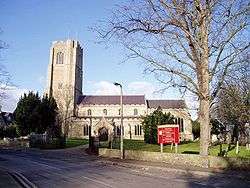 St George's Church | |
 Littleport Littleport shown within Cambridgeshire | |
| Area | 28.46 sq mi (73.7 km2) [1] |
| Population | 8,738 (2011)[2] |
| • Density | 307/sq mi (119/km2) |
| OS grid reference | TL568868 |
| • London | 67.4 mi (108.5 km) S |
| District | |
| Shire county | |
| Region | |
| Country | England |
| Sovereign state | United Kingdom |
| Post town | ELY |
| Postcode district | CB6 |
| Dialling code | 01353 |
| Police | Cambridgeshire |
| Fire | Cambridgeshire |
| Ambulance | East of England |
| EU Parliament | East of England |
| UK Parliament | |
Littleport is the largest village by area in East Cambridgeshire, England.[3] It lies about 6 miles (10 km) north-east of Ely and 6 miles (10 km) south-east of Welney, on the Bedford Level South section of the River Great Ouse, close to Burnt Fen and Mare Fen. There are two primary schools: Millfield Primary and Littleport Community School and one secondary school: Littleport and East Cambridgeshire Academy. The Littleport riots of 1816 were a factor in Parliament passing the Vagrancy Act of 1824.
History
With an Old English name of Litelport, the village was worth 17,000 eels a year to the Abbots of Ely in 1086.[4]
The legendary founder of Littleport was King Canute. A fisherman gave the king shelter one night, after drunken monks had denied him hospitality. After punishing the monks, the king made his host the mayor of a newly founded village.[5]
Littleport was the site of the Littleport Riots of 1816 after war-weary veterans from the Battle of Waterloo had returned home, only to find that they could get no work and the grain prices had gone up. They took to the streets and smashed shops and other buildings until troops were brought in.[6] St George's church registers were destroyed during the riots.[7] The remaining registers start from 1754 (marriages), 1756 (burials), and 1783 (baptisms). Some original documents relating to the riots are held in Cambridgeshire Archives and Local Studies at the County Record Office, Cambridge.[8]
In 2003, a Harley-Davidson statue was unveiled in Littleport to commemorate the centenary of the motorcycle company. William Harley, father of the company's co-founder William Sylvester Harley, had been born in Victoria Street, Littleport, in 1835 and emigrated to the United States in 1859.[9]
Governance
Littleport is a civil parish with an elected council. Parish council meetings are held in the Barn.[10]
The second layer of local government in Littleport was Ely Rural District from 1894 to 1974,[11] when East Cambridgeshire District Council was formed based in Ely. The third layer is Cambridgeshire County Council based in Cambridge.[10]
The parish belongs to the Parliamentary constituency of North East Cambridgeshire. For the European Parliament, it is part of the East of England constituency, which elects seven MEPs using the d'Hondt method of party-list proportional representation.
Economy
Thomas Peacock, who founded the gentlemen's tailoring chain Hope Brothers, was born in Littleport in 1829. The first Hope Brothers shirt-making factory was opened in the village in 1882. For a period in the 1940s and 1950s, Hope Brothers were also manufacturers of the England football kit. The factory was eventually taken over by Burberry.[12]
From 1979–83, Jim Burns guitars were based in Padnal Road in Littleport. They produced guitars such as the Steer, popularized by guitarist Billy Bragg.[13]
Little Ouse
Littleport Parish includes the hamlet of Little Ouse which comes under the Littleport East ward. Little Ouse is now entirely residential: the former pub, the Waterman's Arms and church of St John the Evangelist have been converted into private dwellings.[14]
The lowest trig point in Britain is near Little Ouse; it sits at 3 ft (1m) below sea level.[15]
Climate
With an average annual rainfall of 24 inches (600 mm), Cambridgeshire is one of the driest counties in the British Isles. Protected from the cool onshore coastal breezes east of the region, Cambridgeshire is warm in summer and cold and frosty in winter.[16]
The nearest Met Office weather station is Cambridge NIAB.[17][18]
There are many additional local weather stations reporting periodic figures to the internet. For example, via Weather Underground, Inc.[19]
| Climate data for Cambridge (1971-2000 averages) | |||||||||||||
|---|---|---|---|---|---|---|---|---|---|---|---|---|---|
| Month | Jan | Feb | Mar | Apr | May | Jun | Jul | Aug | Sep | Oct | Nov | Dec | Year |
| Average high °F (°C) | 44.6 (7.0) |
45.3 (7.4) |
50.4 (10.2) |
54.7 (12.6) |
61.7 (16.5) |
66.9 (19.4) |
72 (22.2) |
72.1 (22.3) |
66 (18.9) |
58.3 (14.6) |
49.8 (9.9) |
46 (7.8) |
57.4 (14.1) |
| Average low °F (°C) | 34.3 (1.3) |
34 (1.1) |
37.2 (2.9) |
39.2 (4.0) |
44.1 (6.7) |
49.6 (9.8) |
53.6 (12.0) |
53.4 (11.9) |
50.2 (10.1) |
44.8 (7.1) |
38.7 (3.7) |
36.1 (2.3) |
43 (6.1) |
| Average rainfall inches (mm) | 1.772 (45.0) |
1.287 (32.7) |
1.634 (41.5) |
1.697 (43.1) |
1.752 (44.5) |
2.118 (53.8) |
1.504 (38.2) |
1.921 (48.8) |
2.008 (51.0) |
2.118 (53.8) |
2.012 (51.1) |
1.969 (50.0) |
21.791 (553.5) |
| Source: Met Office | |||||||||||||
Demography
Littleport is 28.46 square miles (73.7 km2) in size making it the largest village in East Cambridgeshire by area. The city of Ely itself has the highest East Cambridgeshire population with Soham second and Littleport third.[1]
Notable people
- Peter Ackroyd, Biblical scholar, died in a nursing home here
- William Harley, who emigrated to the United States, where his son William Sylvester Harley went into partnership to establish the Harley-Davidson Motorcycle Company[22]
- Fred Hockley, World War II fighter pilot
- James Nightall, posthumously awarded the George Cross for gallantry shown in the Soham rail disaster in 1944
- Marty Scurll, professional wrestler. BOLA 2016 winner and multiple times Progress Wrestling Champion.
- Victor Watson, children's writer and academic, born in Littleport
- Andrew James Page, famous physicist, academician, member of London Institute of Physics
World War II
On 16 December 1944, British double agent Eddie Chapman was flown on a mission to Britain by the Germans in a very fast and manoeuvrable small fighter plane, that took off from a forward Luftwaffe fighter station on the Dutch coast. The purpose of the mission was to monitor the accuracy of V.1 Flying Bombs and V.2 Rocket Missiles falling on London and then to report back their effect on the morale of the population in order to improve the performance and devastation of the attacks. After following the bombs to London, Chapman's fighter rerouted to East Anglia to enable him to bail out over flat ground. The fighter had been specially converted for parachuting by German mechanics to enable his exit, as they had cut a small trap door in the floor. The low flying fighter was picked up by a British night-fighter and was attacked over the dropping zone. Chapman scrambled head first through the trap door, with his parachute initially getting stuck. Whilst floating down to the ground he witnessed the British night-fighter reengage the German fighter, which then burst into flames and exploded in a fireball as it hit the ground killing the remaining crew. Chapman landed near Apes Hall, Littleport, out of the blue in the middle of the night. He woke the farm foreman George Convine by banging on the door of the Hall. To avoid difficult questions, Corvine was told by Chapman that he was a crashed British airman and that he needed him to call the Police.
Local folklore and legends
Black dog hauntings
Littleport is home to two different legends of spectral black dogs, which have been linked to the Black Shuck folklore of the East of England but differ in significant aspects.
Local folklorist W. H. Barrett relates a story set before the English Reformation of a local girl gathering wild mint from a nearby mere who was rescued from a lustful friar by a huge black dog, both of which were killed in the struggle. The local men threw into the mere the body of the friar but buried with honour the dog, which was said to haunt the area after that.[23][24]
Cambridgeshire folklorist Enid Porter relates stories dating from the nineteenth century of a black dog haunting the A10 road between Littleport and the neighbouring hamlet of Brandon Creek, according to which local residents would be kept awake on dark nights by the sounds of howling and travellers would hear trotting feet behind them and feel hot breath on the back of their legs. Local legend says that the dog was awaiting the return of its owner, who had drowned in the nearby River Great Ouse in the early 1800s. This haunting reportedly came to an end in 1906, when a local resident drove his car into something solid, which was never found, next to the spot where the dog's owner supposedly drowned.[25][26]
Cultural reference
Littleport provided the inspiration for Great Deeping, the imaginary location of the Paradise Barn children's novels by Victor Watson, set in the Second World War.[27]
See also
- List of places in Cambridgeshire
- Littleport railway station
- The Boat Race - there were four unofficial boat races held during the Second World War away from London. The 1944 Race was held on the River Great Ouse - between Littleport and Queen Adelaide near Ely
Gallery
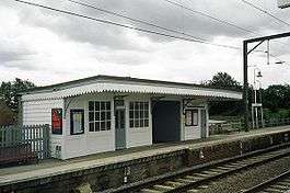 Littleport railway station
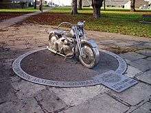 Harley-Davidson monument
Notes and references
- 1 2 3 Research Group (2010). "Historic Census Population Figures". Cambridgeshire County Council. Archived from the original (XLS) on 9 June 2011. Retrieved 19 June 2010.
- 1 2 "Key Figures for 2011 Census: Key Statistics. Area: Littleport (Parish)". ONS. 2013. Retrieved 2 February 2013.
- ↑ Confirmed by the assistant clerk to the Littleport parish council who noted that towns have a town council; villages have a parish council
- ↑ Domesday Book (1999–2010). "Cambridgeshire, Littleport". The Domesday Book Online. © domesdaybook.co.uk. Retrieved 19 June 2010.
- ↑ Beare, Beryl, England: Myths and Legends (Bath, 1999), p. 47. ISBN 0752529781
- ↑ Strawson. "The Littleport Riots". Family website. Strawson family. Archived from the original on 2012-10-11. Retrieved 19 June 2010.
- ↑ T D Atkinson, Ethel M Hampson, E T Long, C A F Meekings, Edward Miller, H B Wells, G M G Woodgate (1953), Pugh, R B, ed., The Victoria History of the Counties of England: Cambridge and the isle of Ely, 4, Oxford University Press, pp. 95–102
- ↑ "County Records Office, Cambridge". Cambridgeshire County Council. 2010. Archived from the original on 16 May 2010. Retrieved 19 June 2010.
- ↑ "Littleport Harley Davidson statue".
- 1 2 ECDC (February 2010). Leaflet:Councillors, committees & meeting dates. The Grange, Nutholt Lane, Ely, CB7 4EE.
- ↑ A Vision of Britain (2004). "A vision of Britain between 1801 and 2001". University of Portsmouth and others. Retrieved 19 June 2010.
- ↑ "Littleport Plaque For Hope Brothers Factory". Archived from the original on 1 August 2012.
- ↑ Gjörde, Per (2001). Pearls and Crazy Diamonds. Göteborg, Sweden: Addit Information AB. pp. 50–54.
- ↑ "Church of St John the Evangelist Little Ouse Littleport, Ely, Cambs". East Cambridgeshire District Council. Archived from the original on 21 September 2010.
- ↑ "Happy 80th birthday to the trig pillar" Ordnance Survey
- ↑ Greig, Dr. A.; Martin, J. (1998). "Cambridgeshire and Peterborough's State of the Environment Report: Chapter 11 Physical Background" (PDF). Cambridgeshire County Council. Archived from the original (PDF) on 9 June 2011. Retrieved 9 June 2010.
- ↑ Met Office. "Forecast:East of England". UK Climate Forecasts. Crown Copyright. Retrieved 5 June 2010.
- ↑ Met Office. "Historical Data:Regional:Cambridge NIAB". UK Climate Summaries. Crown Copyright. Archived from the original on 29 June 2011. Retrieved 5 June 2010.
- ↑ Weather Underground (2010). "Ely, United Kingdom". Weather Underground, Inc. Retrieved 5 June 2010.
- ↑ Area in 1801 26.20 square miles (67.9 km2)
- ↑ No census 1941 due to WWII
- ↑ William Harley Retrieved 20 March 2015
- ↑ Barrett, Walter Henry (1963), Porter, Enid, ed., Tales from the Fens, Routledge & Kegan Paul, ISBN 9780710010544
- ↑ James, Maureen (2014), "Of Strange Phenomena: Black Dogs, Will o' the Wykes and Lantern Men", Cambridgeshire Folk Tales, History Press, ISBN 9780752466286
- ↑ Porter, Enid (1969), Cambridgeshire Customs & Folklore, Routledge & Kegan Paul, ISBN 9780710062017
- ↑ Codd, Daniel (2010), "The Weird Animal Kingdom: Black Shuck and Other Phantom Animals", Mysterious Cambridgeshire, JMD Media, ISBN 9781859838082
- ↑ Series website Retrieved 20 February 2016.
External links
| Wikimedia Commons has media related to Littleport, Cambridgeshire. |
- The Littleport Society
- Littleport Parish Council Website
- Littleport and East Cambs Academy
- 2001 Census
- GenUK's entry for Littleport
- Littleport unveiling of Hope Brothers factory plaque
- Littleport Life Community Magazine
- Littleport Riots (Parish Council Website)
- Littleport Rotary Club
- Littleport Town Cricket Club
Settlements in East Cambridgeshire | ||
|---|---|---|
| Cities |  | |
| Towns | ||
| Villages | Aldreth • Ashley • Barway • Bottisham • Brinkley • Burwell • Chettisham • Cheveley • Chippenham • Coveney • Dullingham • Fordham • Haddenham • Isleham • Little Downham • Little Thetford • Littleport • Lode • Longmeadow • Mepal • Prickwillow • Pymoor • Queen Adelaide • Reach • Stetchworth • Stretham • Stuntney • Sutton • Swaffham Bulbeck • Swaffham Prior • Upware • Wicken • Wilburton • Witcham • Witchford • Woodditton | |