Witcham
| Witcham | |
|---|---|
 Witcham Witcham shown within Cambridgeshire | |
| Population | 429 (2011)[1] |
| OS grid reference | TL463800 |
| Shire county | |
| Region | |
| Country | England |
| Sovereign state | United Kingdom |
| Post town | ELY |
| Postcode district | CB6 |
| Dialling code | 01353 |
| EU Parliament | East of England |
| Website | http://www.witcham.org.uk |
Witcham is a small village near Ely in Cambridgeshire, England.
The village is surrounded by fenland farms and has a village hall and a 13th-century church dedicated to St Martin. It has a pub called the White Horse, which was the winner of the Ely and District CAMRA Rural Pub of the Year Award 2006, 2010, 2011 and Overall Pub of the Year Award 2011. It also has a fine village green.
The village hosts the World Pea Shooting Championships on the second Saturday in July every year and has staged the competition annually since 1971.
Witcham is built around a cross-roads in the centre of the village with each of the four roads having housing on each side for 50-200m. The north-bound street is called "Martins Lane", the east-bound street is "High Street", south-bound is "The Slade", and west-bound is "Silver Street", which leads to the more recent housing developments of "Westway Place" and "The Orchards".
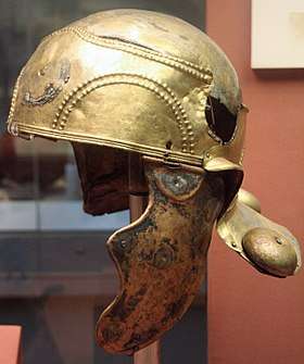
The name of the village derives from "Wycham", meaning "place of the wych elms", after the trees that used to grow there in significant numbers. A Roman cavalry helmet dating from the first century AD, known as the Witcham Gravel helmet, was found in the village gravel pit, and now resides in the British Museum.[2]
Witcham Gravel
Historically, Witcham Parish had several detached portions in the outlying Fens. By 1896, boundary changes had reduced these detached portions to one, separated from the main by a small parish called Witcham Gravel. Witcham Gravel was placed in Ely Urban District, whereas the two parts of Witcham proper were included in Ely Rural District. This situation persisted until 1933, when Witcham Gravel parish was merged into Witcham.[3][4][5]
References
- ↑ "Key Figures for 2011 Census: Key Statistics. Area: Witcham (Parish)". ONS. 2013. Retrieved 2 February 2013.
- ↑ British Museum Collection
- ↑ "South Witchford Hundred: Witcham". Victoria County History. British History Online. 2002. Retrieved 15 June 2017.
- ↑ "Witcham CP/AP through time: Census tables with data for the Parish-level Unit, A Vision of Britain through Time". GB Historical GIS / University of Portsmouth. Retrieved 15 June 2017.
- ↑ "Kelly's Directory - Cambridgeshire - Witcham". Cambridgeshire History. 1929. Retrieved 15 June 2017.
External links
| Wikimedia Commons has media related to Witcham. |
- 2011 Census
- Village Archive
- Village Website
- Pictures of the 2017 World Pea Shooting Championship in Witcham
- World Pea Shooting Championship
- Village Facebook Page
Settlements in East Cambridgeshire | ||
|---|---|---|
| Cities |  | |
| Towns | ||
| Villages | Aldreth • Ashley • Barway • Bottisham • Brinkley • Burwell • Chettisham • Cheveley • Chippenham • Coveney • Dullingham • Fordham • Haddenham • Isleham • Little Downham • Little Thetford • Littleport • Lode • Longmeadow • Mepal • Prickwillow • Pymoor • Queen Adelaide • Reach • Stetchworth • Stretham • Stuntney • Sutton • Swaffham Bulbeck • Swaffham Prior • Upware • Wicken • Wilburton • Witcham • Witchford • Woodditton | |