List of volcanoes in Bolivia
The country of Bolivia hosts numerous active[i 1] and extinct volcanoes across its territory. The active volcanoes are in western Bolivia making up the Cordillera Occidental, the western limit of the Altiplano plateau. Many of the active volcanoes are international mountains shared with Chile. All Cenozoic volcanoes of Bolivia are part of the Central Volcanic Zone (CVZ) of the Andean Volcanic Belt that results due to processes involved in the subduction of Nazca Plate under the South American Plate. The Central Volcanic Zone is a major upper Cenozoic volcanic province.[1] Apart from Andean volcanoes the geology of Bolivia host the remnants of ancient volcanoes around the Precambrian Guaporé Shield in the eastern part of the country.
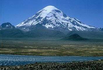 Sajama, a stratovolcano considered extinct.
 View of Licancabur. The summit area is in Chile.
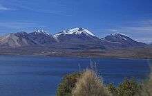 Acotango volcano seen from Chile.
See also
Notes
References
- Siebert L, Simkin T (2002–present). Volcanoes of the World: an Illustrated Catalog of Holocene Volcanoes and their Eruptions. Smithsonian Institution, Global Volcanism Program Digital Information Series, GVP-3 (http://www.volcano.si.edu).
- ↑ Baker, M.C.W; Francis, P.W (1978), "Upper Cenozoic volcanism in the Central Andes — Ages and volumes", Earth and Planetary Science Letters, 41 (2): 175, doi:10.1016/0012-821X(78)90008-0
This article is issued from
Wikipedia.
The text is licensed under Creative Commons - Attribution - Sharealike.
Additional terms may apply for the media files.