| Name |
Image |
Location |
Coordinates |
Year first lit |
Automated |
Year deactivated |
Current Lens |
Focal Height |
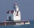
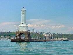
| Algoma Pierhead Light |
 |
Algoma |
44°36′25″N 87°25′45″W / 44.6070°N 87.4293°W / 44.6070; -87.4293 (Algoma Pierhead Light) |
1932 |
1973 |
Active |
Plastic |
048 48 ft (15 m) |
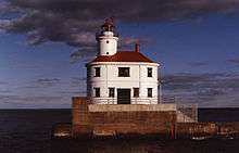
| Ashland Harbor Breakwater Light |
 |
Ashland |
46°37′42″N 90°52′14″W / 46.6282°N 90.8706°W / 46.6282; -90.8706 (Ashland Harbor Breakwater Light) |
1915 |
1962 |
Active |
250mm |
060 60 ft (18 m) |
| Asylum Light |
 |
Oshkosh |
44°03′44″N 88°30′53″W / 44.062361°N 88.514639°W / 44.062361; -88.514639 |
Never Lit |
N/A |
N/A |
None |
Unknown |
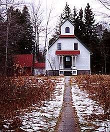
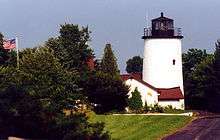
| Baileys Harbor Light |
 |
Baileys Harbor |
45°03′21″N 87°05′49″W / 45.0559°N 87.0970°W / 45.0559; -87.0970 (Baileys Harbor Light)[3] |
1853 |
Never |
1869
(Now a private home) |
None |
054 54 ft (16 m)[4] |
| Baileys Harbor Range Front Light |
 |
Baileys Harbor |
45°04′13″N 87°07′11″W / 45.0704°N 87.1198°W / 45.0704; -87.1198 (Baileys Harbor Range Front Light)[5] |
1870 |
1930 |
Active
(Inactive: 1969-2015) |
LED |
021 21 ft (6.4 m)[4] |
| Baileys Harbor Range Rear Light |
 |
Baileys Harbor |
45°04′22″N 87°07′16″W / 45.0729°N 87.121°W / 45.0729; -87.121 (Baileys Harbor Range Rear Light)[6] |
1870 |
1930 |
Active
(Inactive: 1969-2015) |
LED |
036 36 ft (11 m)[4] |
| Calumet Light |
 |
Calumet |
43°54′54″N 88°19′56.5″W / 43.91500°N 88.332361°W / 43.91500; -88.332361 |
1936 |
Never |
Active |
Unknown |
Unknown |
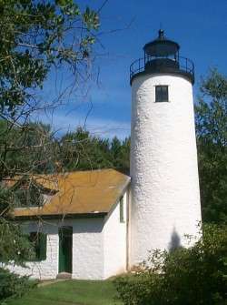
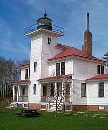
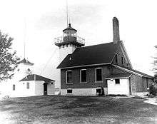
| Cana Island Light |
 |
Baileys Harbor |
45°05′17″N 87°02′51″W / 45.0881°N 87.0476°W / 45.0881; -87.0476 (Cana Island Light) |
1870 |
1945 |
Active |
Unknown |
083 83 ft (25 m) |
| Chambers Island Light |
 |
Gibraltar
(Chambers Island) |
45°12′08″N 87°21′53″W / 45.2022°N 87.3648°W / 45.2022; -87.3648 (Chambers Island Light)[7] |
1868 |
1955 |
1961 |
None |
068 68 ft (21 m)[7] |
| Chequamegon Point Light |
 |
Apostle Islands
(Long Island) |
46°43′43″N 90°48′33″W / 46.7285°N 90.8093°W / 46.7285; -90.8093 (Chambers Island Light) |
1896[8] |
1964 |
1987 |
None |
042 42 ft (13 m)[8] |
| Devils Island Light |
 |
Apostle Islands
(Devils Island) |
47°04′46″N 90°43′41″W / 47.0795°N 90.7281°W / 47.0795; -90.7281 (Devils Island Light) |
1891 (Former)
1901 (Current) |
1978 |
Active |
Third-order Fresnel |
100 100 ft (30 m) |
| Dunlap Reef Range Lights |
|
Sturgeon Bay |
N/A |
1881 |
Never |
1924
(The rear range light
is now a private home) |
None |
018 18 ft (5.5 m)
(Front Range)
039 39 ft (12 m)
(Rear Range) |
| Eagle Bluff Light |
 |
Ephraim |
45°10′07″N 87°14′12″W / 45.1687°N 87.2367°W / 45.1687; -87.2367 (Eagle Bluff Light) |
1868 |
1926 |
Active |
Fifth-order Fresnel |
075 75 ft (23 m) |
| Fond du Lac Light |
 |
Fond du Lac |
43°47′51.54″N 88°26′14.09″W / 43.7976500°N 88.4372472°W / 43.7976500; -88.4372472 |
1933 |
Never |
Active |
Unknown |
Unknown |
| Grassy Island Range Lights |
 |
Green Bay |
44°33′36″N 87°59′35″W / 44.560°N 87.993°W / 44.560; -87.993 (Grassy Island Range Lights (original))[9]
(Original)
44°32′10″N 88°00′19″W / 44.5362°N 88.0052°W / 44.5362; -88.0052 (Grassy Island Range Lights (current))[10]
(Current) |
1872 |
1934 |
1966 |
None |
035 35 ft (11 m)[4]
(Upper light)
27 ft (8.2 m)[4]
(Lower light) |
| Green Bay Harbor Entrance Light |
 |
Green Bay |
44°39′11″N 87°54′05″W / 44.6531°N 87.9013°W / 44.6531; -87.9013 (Green Bay Harbor Entrance Light) |
1935 |
1979 |
Active |
Unknown |
072 72 ft (22 m) |
| Green Island Light |
 |
Peshtigo
(Green Island) |
45°03′23″N 87°29′34″W / 45.0564°N 87.4929°W / 45.0564; -87.4929 (Green Island Light)[11] |
1863 |
1933 |
1956
(Now in ruins) |
None |
055 55 ft (17 m)[11] |
| Gull Island Light |
|
Apostle Islands
(Gull Island) |
46°54′24″N 90°26′36″W / 46.9067°N 90.4433°W / 46.9067; -90.4433 (Gull Island Light) |
1929 |
Always |
Active |
250mm |
056 56 ft (17 m) |
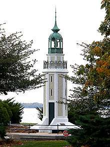
Kenosha Light
(Orig: Kenosha North Pierhead Light) |
 |
Kenosha |
42°35′22″N 87°48′57″W / 42.5894°N 87.8157°W / 42.5894; -87.8157 (Kenosha Light)[12] |
1840 (Former)
1867 (Current) |
1996
(Relit) |
Active
(Inactive: 1906-1996) |
Replica |
050 50 ft (15 m)[4] |
| Kenosha North Pier Light |
 |
Kenosha |
42°35′20″N 87°48′31″W / 42.5888°N 87.8086°W / 42.5888; -87.8086 (Kenosha North Pier Light) |
1848 (Former)
1906 (Current) |
1925 |
Active |
Fourth-order Fresnel |
050 50 ft (15 m) |
| Kevich Light |
 |
Grafton |
43°19′24″N 87°53′19″W / 43.3233°N 87.8885°W / 43.3233; -87.8885 (Kevich Light) |
1981 |
Always |
Active |
Halide lamps |
163 163 ft (50 m) |
| Kewaunee Pierhead Light |
 |
Kewaunee |
44°27′27″N 87°29′34″W / 44.4574°N 87.4929°W / 44.4574; -87.4929 (Kewaunee Pierhead Light) |
1889 (Former)
1931 (Current) |
1981 |
Active |
Fifth-order Fresnel |
045 45 ft (14 m) |
| La Pointe Light |
 |
Apostle Islands
(Long Island) |
46°43′43″N 90°47′06″W / 46.7287°N 90.7849°W / 46.7287; -90.7849 (La Pointe Light) |
1858 (Former)
1896 (Current) |
1964 |
Active |
300mm |
070 70 ft (21 m) |
Long Tail Point Light
(First) |
|
Green Bay |
44°35′45″N 87°59′01″W / 44.5959°N 87.9835°W / 44.5959; -87.9835 (Long Tail Point Light)[13] |
1848 |
Never |
1859
(Now in ruins) |
None |
056 56 ft (17 m) |
Long Tail Point Light
(Second) |
|
Green Bay |
N/A |
1859 |
Never |
1899
(Destroyed in 1936) |
None |
Unknown |
Long Tail Point Light
(Third) |
 |
Green Bay |
N/A |
1899 |
1936 |
1973
(Destroyed) |
None |
Unknown |
| Manitowoc Breakwater Light |
 |
Manitowoc |
44°05′34″N 87°38′37″W / 44.0928°N 87.6436°W / 44.0928; -87.6436 (Manitowoc Breakwater Light) |
1839 (Former)
1918 (Current) |
1971 |
Active |
Unknown |
052 52 ft (16 m) |
Michigan Island Light
(New) |
 |
Apostle Islands
(Michigan Island) |
46°52′17″N 90°29′50″W / 46.8714°N 90.4971°W / 46.8714; -90.4971 (Michigan Island Light) |
1929 |
1943 |
Active |
LED |
170 170 ft (52 m) |
Michigan Island Light
(Old) |
 |
Apostle Islands
(Michigan Island) |
N/A |
1857 |
Never |
1929
(Replaced) |
None |
Unknown |
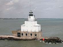
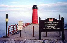
| Milwaukee Breakwater Light |
 |
Milwaukee |
43°01′37″N 87°52′55″W / 43.0269°N 87.8819°W / 43.0269; -87.8819 (Milwaukee Breakwater Light) |
1899 (Former)
1926 (Current) |
1966 |
Active |
Unknown |
061 61 ft (19 m) |
| Milwaukee Pierhead Light |
 |
Milwaukee |
43°01′33″N 87°53′43″W / 43.0259°N 87.8953°W / 43.0259; -87.8953 (Milwaukee Pierhead Light) |
1872 |
1939 |
Active |
Unknown |
048 48 ft (15 m) |
Neenah Light
(aka:Kimberly Point Lighthouse) |
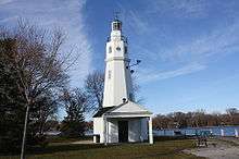 |
Neenah |
N/A |
1945 |
Always |
Active |
Unknown |
Unknown |
| North Point Light |
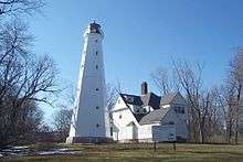 |
Milwaukee |
43°03′56″N 87°52′17″W / 43.0656°N 87.8714°W / 43.0656; -87.8714 (North Point Light)[14] |
1855 (Former)
1888 (Current) |
1943 |
1994 |
None |
154 154 ft (47 m)[14] |
| Outer Island Light |
 |
Apostle Islands
(Outer Island) |
47°04′35″N 90°25′00″W / 47.0765°N 90.4167°W / 47.0765; -90.4167 (Outer Island Light) |
1874 |
1961 |
Active |
VRB-25 |
130 130 ft (40 m) |
| Peshtigo Reef Light |
 |
Green Bay
(Offshore) |
44°57′24″N 87°34′45″W / 44.9566°N 87.5791°W / 44.9566; -87.5791 (Peshtigo Reef Light) |
1936 |
Always |
Active |
Unknown |
072 72 ft (22 m) |
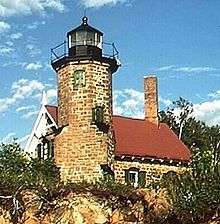
| Pilot Island Light |
 |
Gills Rock |
45°17′03″N 86°55′11″W / 45.2842°N 86.9197°W / 45.2842; -86.9197 (Pilot Island Light) |
1858 |
1962 |
Active |
Unknown |
048 48 ft (15 m) |
| Plum Island Range Front Light |
 |
Plum Island |
45°18′14″N 86°57′18″W / 45.3038°N 86.9550°W / 45.3038; -86.9550 (Plum Island Range Front Light)
(Current location) |
1897 |
Never |
1964 |
None |
032 32 ft (9.8 m)[4] |
| Plum Island Range Rear Light |
 |
Plum Island |
45°18′27″N 86°57′30″W / 45.3076°N 86.9582°W / 45.3076; -86.9582 (Plum Island Range Rear Light) |
1897 |
1969 |
Active |
Fourth-order Fresnel |
084 84 ft (26 m) |
| Port Washington Light |
 |
Port Washington |
43°23′28″N 87°52′04″W / 43.391°N 87.8677°W / 43.391; -87.8677 (Port Washington Light)[15] |
1849 (Former)
1860 (Current) |
Never |
1903
(Now a museum) |
Fourth-order Fresnel
(Replica) |
113 133 ft (41 m)[16] |
| Port Washington Breakwater Light |
 |
Port Washington |
43°23′07″N 87°51′35″W / 43.3853°N 87.8597°W / 43.3853; -87.8597[17] |
1889 (Former)
1935 (Current) |
1976 |
Active |
Unknown |
078 78 ft (24 m) |
| Pottawatomie Light |
 |
Rock Island |
45°25′39″N 86°49′44″W / 45.4276°N 86.8288°W / 45.4276; -86.8288 (Pottawatomie Light) |
1836 (Former)
1858 (Current) |
1946 |
1988 |
Fourth-order Fresnel
(Replica) |
159 159 ft (48 m) |
| Racine Harbor Light |
 |
Racine |
42°44′03″N 87°46′42″W / 42.7341°N 87.7783°W / 42.7341; -87.7783 (Racine Harbor Light)[18] |
1839 (Former)
1901 (Current) |
Never |
1901 |
None |
075 75 ft (23 m) |
| Racine North Breakwater Light |
|
Racine |
42°44′05″N 87°46′19″W / 42.7346°N 87.7720°W / 42.7346; -87.7720 (Racine North Breakwater Light)[19] |
1872 (Former)
1904 (Current) |
Unknown |
1987[19] |
None |
053 53 ft (16 m)[20] |
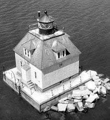
| Racine Reef Light |
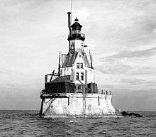 |
Racine |
42°43′39″N 87°44′10″W / 42.7276°N 87.7361°W / 42.7276; -87.7361 (Racine Reef Light) |
1899 (Former)
1906 (Current) |
1954 |
1961 |
None |
072 72 ft (22 m)[4] |
| Raspberry Island Light |
 |
Apostle Islands
(Raspberry Island) |
46°58′14″N 90°48′18″W / 46.9706°N 90.8050°W / 46.9706; -90.8050 (Raspberry Island Light)[21] |
1862 |
1947 |
1957
(Now a museum) |
None |
077 77 ft (23 m)[22] |
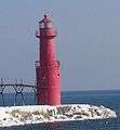
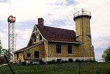
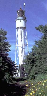
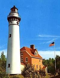
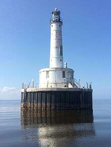
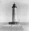
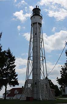
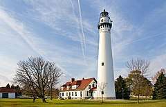
| Rawley Point Light |
.jpg) |
Two Rivers |
44°12′39″N 87°30′32″W / 44.2108°N 87.5088°W / 44.2108; -87.5088 (Rawley Point Light) |
1874 (Former)
1894 (Current) |
1979 |
Active |
Optic |
113 113 ft (34 m) |
Rockwell Light
(aka: Bray's Point Light) |
 |
Oshkosh |
N/A |
1910 |
Unknown |
1965
(Estimated) |
None |
026 26 ft (7.9 m) |
| Sand Island Light |
 |
Apostle Islands
(Sand Island) |
47°00′12″N 90°56′15″W / 47.0033°N 90.9374°W / 47.0033; -90.9374 (Sand Island Light) |
1881 |
1921 |
Active
(Inactive: 1933-1985) |
LED |
060 60 ft (18 m) |
| Sheboygan Lighthouse |
 |
Sheboygan |
43°44′58″N 87°41′34″W / 43.7495°N 87.6927°W / 43.7495; -87.6927 (Sheboygan Breakwater Light) |
1839 (Former)
1915 (Current) |
Unknown |
Active |
Unknown |
055 55 ft (17 m) |
| Sherwood Point Light |
 |
Nasewaupee
(Idlewild) |
44°53′34″N 87°26′00″W / 44.8928°N 87.4334°W / 44.8928; -87.4334 (Sherwood Point Light) |
1883 |
1983 |
Active |
Unknown |
061 61 ft (19 m) |
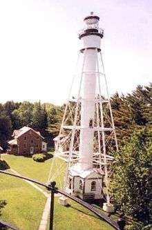
| Sturgeon Bay Canal Light |
 |
Sturgeon Bay |
44°47′42″N 87°18′48″W / 44.7950°N 87.3133°W / 44.7950; -87.3133 (Sturgeon Bay Canal Light) |
1899 |
1972 |
Active |
Unknown |
107 107 ft (33 m) |
Sturgeon Bay Canal
North Pierhead Light |
 |
Sturgeon Bay |
44°47′31″N 87°18′34″W / 44.7920°N 87.3095°W / 44.7920; -87.3095 (Sturgeon Bay Canal North Pierhead Light) |
1882 (Former)
1903 (Current) |
1972 |
Active |
300mm |
040 40 ft (12 m) |
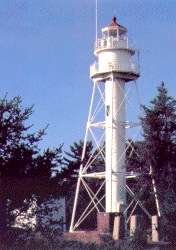
Superior Entry Breakwater Light
(aka: Wisconsin Point Light) |
 |
Superior |
46°42′37″N 92°00′22″W / 46.7102°N 92.0062°W / 46.7102; -92.0062 (Wisconsin Point Light) |
1913 |
1970 |
Active |
DCB-224 |
070 70 ft (21 m) |
| Two Rivers Light |
 |
Two Rivers |
44°08′34″N 87°33′38″W / 44.1428°N 87.5605°W / 44.1428; -87.5605 (Two Rivers Light (original))
(Original)
44°09′12″N 87°33′45″W / 44.1532°N 87.5624°W / 44.1532; -87.5624 (Two Rivers Light (current))[23]
(Current) |
1886 |
Never |
1969
(Now a museum) |
None |
035 35 ft (11 m)[24] |
| Wind Point Light |
 |
Racine
(Wind Point) |
42°46′52″N 87°45′30″W / 42.7811°N 87.7583°W / 42.7811; -87.7583 (Wind Point Light) |
1880 |
1964 |
Active |
VRB-25 |
111 111 ft (34 m) |